Nainital (District)
| Nainital District नैनीताल ज़िला |
|
|---|---|

|
|
| State | Uttarakhand |
| Division : | Kumaon |
| Administrative headquarters : | Nainital |
| Area : | 4251 km² |
| Residents : | 954,605 (2011) |
| Population density : | 225 inhabitants / km² |
| Website : | nainital.nic.in |
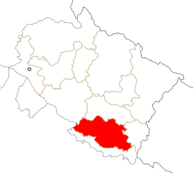
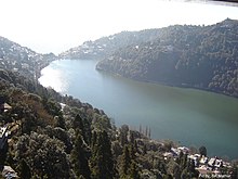
The district of Nainital ( Hindi : नैनीताल ज़िला ) is a district of the Indian state of Uttarakhand . The district administration is based in Nainital - on the lake of the same name .
geography

The Nainital District is located in the extreme south of the Kumaon Himalayas in the Kumaon Division in the southeast of Uttarakhand. In the east lies Champawat , in the south Udham Singh Nagar , in the west the state of Uttar Pradesh and the district of Pauri Garhwal . In the north Nainital borders on Almora . Most of the district is in the Siwaliks . The Kosi River runs in the northwest . The Ganges plain lies in the south of the district . The largest city in the district is Haldwani - located at the foot of the Siwaliks with 232,060 inhabitants (as of 2011, urban agglomeration). The area of the district Nainital is 4251 km².
population
According to the 2011 census, the Nainital district has 954,605 inhabitants.
Web links
Individual evidence
- ↑ Census of India 2011: Primary Census Abstract - Urban Agglomerations / Cities (PDF; 138 kB)
- ↑ Census of India 2011: Primary Census Abstract - Uttarakhand. (PDF; 471 kB)
Coordinates: 29 ° 22 ' N , 79 ° 33' E

