
Napf (mountain)
| Bowl | ||
|---|---|---|
 Napf summit with triangulation point from 1860 |
||
| height | 1406 m above sea level M. | |
| location |
|
|
| Mountains | Emmental Alps | |
| Dominance | 10.63 km → Farnere | |
| Notch height | 552 m ↓ Escholzmatt | |
| Coordinates | 638 129 / 206023 | |
|
||

The bowl is 1406 m above sea level. M. the highest peak of the Napfbergland in the Emmental Alps of Switzerland . The summit with the mountain restaurant is in the municipal area of Trub . The border between the cantons of Bern and Lucerne runs a little north of the summit .
geography

The Napf is part of a high mountain ridge running in a west-east direction , which stretches from the Farnli donkey via the Höchänzi and the Napf to the stallion. Both to the north and to the south, the Napf slopes down with very steep and densely wooded (fir-beech forests) slopes. The Luthern and Enziwigger rises on the mountain slopes , flowing north through deep valley valleys and belonging to the Wigger catchment area . The Trueb , which flows through the Fankhausgraben to the Ilfis (right tributary of the Emme ), has its origin on the southern slope of the Napf .
Climate table
| Napf, 1981-2010 | ||||||||||||||||||||||||||||||||||||||||||||||||
|---|---|---|---|---|---|---|---|---|---|---|---|---|---|---|---|---|---|---|---|---|---|---|---|---|---|---|---|---|---|---|---|---|---|---|---|---|---|---|---|---|---|---|---|---|---|---|---|---|
| Climate diagram | ||||||||||||||||||||||||||||||||||||||||||||||||
| ||||||||||||||||||||||||||||||||||||||||||||||||
|
Average monthly temperatures and rainfall for Napf, 1981–2010
Source:
|
||||||||||||||||||||||||||||||||||||||||||||||||||||||||||||||||||||||||||||||||||||||||||||||||||||||||||||||||||||||||||||||||||||||||||||||||||||||||||||||||||||||||||||||||||||
geology
The mountain consists of rock layers that were deposited on the northern edge of the Alps by powerful rivers from the Alps at the time of the Upper Freshwater Molasse . These rivers often carried a lot of debris with them, which is why the bowl is mainly made up of Nagelfluh , a conglomerate of rounded rock blocks of different sizes that are consolidated into a coherent rock with a binding agent (lime, sand and clay). Fine-grained sandstone and marl layers are also embedded between the Nagelfluh layers .
Hiking routes
The starting point for hikes to the Napf summit are the Mettlenalp ( 1052 m above sea level ) in the south and Luthern ( 778 m above sea level ) as well as the Luthern Bad ( 875 m above sea level ) and Wiggernhütte (municipality of Hergiswil near Willisau) in North of the mountain.
The two hiking routes No. 3 Alpenpanorama-Weg (stage 15 Napf – Lüderenalp) and No. 65 Grenzpfad Napfbergland from SwitzerlandMobility lead over the Napf .
gallery
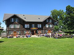
Berghotel Napf

View towards the Bernese Alps

Nagelfluh rock on the Napf

Hiking trail from the Wiggerenhütte


panorama
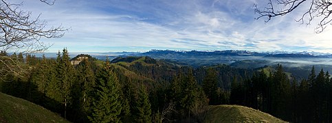
Southeast panorama
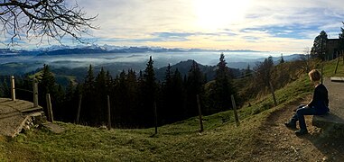
Southwest panorama
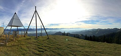
Southwest panorama at the triangulation point


See also
Web links
- Hiking suggestions
- Hiking suggestions Luthertal
- Hiking in Switzerland: No. 3 Alpine Panorama Trail
- Hiking in Switzerland: No. 65 Grenzpfad Napfbergland
- Berghotel Napf
- Website landscape areas Napf area
supporting documents
- ↑ a b Position of the triangulation point in maps of Switzerland (SwissTopo)
- ↑ Ernst Höhne: Knaurs Lexikon für Bergfreunde / The Alps between Matterhorn and Lake Constance . Droemer Knaur, Munich 1987, ISBN 3-426-26223-1 , p. 196 .
- ↑ Climate table. In: meteoschweiz.admin.ch. meteoschweiz, accessed on May 24, 2018 .