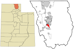
Nibley, Utah
| Nibley | |
|---|---|
 |
|
| Location of Nibley in Cache County | |
| Basic data | |
| Foundation : | August 30, 1935 |
| State : | United States |
| State : | Utah |
| County : | Cache County |
| Coordinates : | 41 ° 40 ′ N , 111 ° 51 ′ W |
| Time zone : | Mountain ( UTC − 7 / −6 ) |
| Residents : | 5,438 (as of 2010) |
| Population density : | 520.9 inhabitants per km 2 |
| Area : | 10.44 km 2 (about 4 mi 2 ) of which 10.44 km 2 (about 4 mi 2 ) is land |
| Height : | 1388 m |
| Postal code : | 84321 |
| Area code : | +1 435 |
| FIPS : | 49-54660 |
| GNIS ID : | 1443818 |
| Website : | www.nibleycity.com |
| Mayor : | Shaun Dustin |
Nibley is a small town ( city ) in Cache County in the state of Utah in the United States . At the last census in 2010 , Nibley had 5,438 inhabitants, more than twice as many as in 2000.
location
Nibley is in the Cache Valley and is a suburb of Logan . Nibley is about seven kilometers south of Logan, 100 kilometers north of Salt Lake City as the crow flies, and 35 kilometers south of the Idaho border . It is bordered by Millville to the north, Hyrum to the south, and College Ward to the west .
history
The area around what is now Nibley was originally settled by Shoshone Indians before Mormon settlers began to settle in the region in 1824 . In 1849 the Cache Valley was surveyed by the US Army Corps of Engineers and given to the landowner Brigham Young, who used the land for raising cattle. In 1855 a ranch called Elk Horn Ranch was established in the area of present-day Nibley , and it became the first Mormon settlement in Cache Valley. Shortly afterwards the village was given up again.
In 1860 a new settlement was built on the east bank of the Blacksmith Fork River , the new location of the settlement was better protected from attacks by the indigenous people living in the area. The new village was named Millville Ward . After a battle between the Indians and the settlers who had moved in in 1863, the Shoshone were expelled into Indian reservations and the settlement was again expanded to the west. In the 1920s, Millville Ward was divided into two settlements, the village on the west bank of the Blacksmith Fork River was renamed Nibley Ward , the settlement was named after the Mormon priest Charles Wilson Nibley .
On May 21, 1935, a council meeting discussed the incorporation of Nibley as an independent city. On August 30, 1935, the founding application was approved and Nibley was incorporated as a city.
population
| growth of population | |||
|---|---|---|---|
| Census | Residents | ± in% | |
| 1940 | 271 | - | |
| 1950 | 304 | 12.2% | |
| 1960 | 333 | 9.5% | |
| 1970 | 367 | 10.2% | |
| 1980 | 1036 | 182.3% | |
| 1990 | 1167 | 12.6% | |
| 2000 | 2045 | 75.2% | |
| 2010 | 5348 | 161.5% | |
| US Decennial Census | |||
2010 Census
At the 2010 United States Census, Nibley had 5348 residents, divided into 1412 households and 1299 families. 91.7% of the population were White , 0.2% African American , 0.5% Native American, 0.5% Asian, and 0.2% Pacific Islander ; 5.2% of the population were of other races and 1.7% had two or more races. Hispanics and Latinos made up 10.1% of the total population. There were married couples in 83.6% of households, 6.1% of households were made up of single women and 2.3% of single men. 65.7% of households had children under the age of 18 living with them and 10.3% of households had seniors over 65 years of age.
The median age in Nibley in 2010 was 24.8 years. 45.4% of the residents were younger than 18 years, 4.9% were between 18 and 24, 32.0% between 25 and 44, 13.6% between 45 and 64 and 4.1% of the residents were 65 years or older older. 49.7% of the population were male and 50.3% female.
Census 2000
In the 2000 United States Census , Nibley had 2,045 residents in 566 households and 516 families. 96.67% of the population were White, 0.15% Native Americans, 0.39% Asian, and 0.15% were from the Pacific Islander area; 1.27% were of other parentage and 1.37% were of multiple parentage. 3.86% of the total population were Hispanics or Latinos.
At the time of the census, the median income in Nibley was $ 52,273 per household and $ 54,896 per family. The average per capita income was $ 17,168. 1.3% of families and 1.1% of Nibley residents were below the poverty line , with 1.1% under 18 and none over 65 years of age.
Economy and Infrastructure
Nibley is on Utah Highway 165 , which runs north-south through the city, and about four kilometers east of US Highway 89 between the city of Ogden and the Idaho border. The school district of Nibley has two elementary schools and secondary schools are in the neighboring towns.
Nibley is a commuter community and most of the city's residents work in Logan.
Web links
Individual evidence
- ^ A Brief History of Nibley City. In: nibleycity.com , accessed November 10, 2019.
- ^ Profile of General Population and Housing Characteristics. United States Census Bureau, accessed November 10, 2019.

