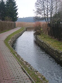
Niemica (river)
|
Niemica Nemitz, Nemitzbach, Niemitzbach, Niemcza |
||
| Data | ||
| location | Poland , West Pomeranian Voivodeship , Powiat Kamieński | |
| River system | Świniec | |
| Drain over | Świniec → Kaminer Haff → Dziwna → Baltic Sea | |
| River basin district | Or | |
| source | near the lake Żabie in nature reserve Rezerwat Golczewskie Uroczysko 53 ° 49 '32 " N , 15 ° 1' 21" O |
|
| Source height | 50 m above sea level NHN | |
| muzzle | at Borucin in the Świniec coordinates: 53 ° 58 '23 " N , 14 ° 49' 7" O 53 ° 58 '23 " N , 14 ° 49' 7" O
|
|
| length | 27 km | |
| Catchment area | 112.6 km² | |
| Flowing lakes | Szczucze-See (German: Obersee), Okonie-See (German: Untersee) | |
| Small towns | Golczewo | |
| Communities | Gmina Golczewo, Gmina Kamien Pomorski, Gmina Swierzno, | |
The Niemica (German: Nemitz-Bach ) is a 27 km long tributary of the Świniec ( German : Schwenzer Bach ) in the West Pomeranian Voivodeship in the Powiat Kamieński in Poland and flows through the Greifenberg plain. The entire catchment area of the Niemica River is 112.6 km².
course

The source of the Niemica is located south of Lake Żabie (German: frog pond ), near the disused railway line No. 420 . First it flows in a south-westerly direction to Lake Szczucze (German name: Obersee ) after flowing through the ponds adjacent to the south-eastern bank. The stream flows from the north bank of the Szczucze lake through Golczewo under the national road 108 and flows into the Okonie lake (German name: Untersee ) after approx. 250 m . The Niemica then flows from the northwestern bank of Lake Okonie and meanders in a northwestern direction with a slight bend to the east towards the village of Niemica (German: Nemitz ). From Niemica it flows further northwest through the village of Szumiąca (German: Königsmühl ). From Szumiąca the small river, which can be navigated here by canoe, flows through wooded river banks in a north-westerly direction. Northwest of Borucin and southeast of the village Grabowo near Kamień Pomorski (German: Cammin "in Pommern" ) it unites with the river Świniec (German: Schwenzer Bach ). The Świniec flows towards the west, where it flows into the Zalew Kamieński (German: Kaminer Haff ).
Localities
- Golczewo (German: Gülzow )
- Samlino (German: Zemlin )
- Niemica (German: Nemitz )
- Szumiąca (German: Königsmühl )
- Mokrawica (German: Mokratz )
- Borucin (German: Marquardsmühl )
Environment and nature protection

According to data from the regional water authority, roach and perch in particular dominate the waters of the Niemica. Further occurrences of species in the river are tench , pike , burbot , bleak , rudd , bream and gudgeon .
In 2008, a survey was carried out on the water quality of the Niemica at the beginning of the mouth of the Świniec. The result of the physical and chemical components suggests a poor condition.
tourism
The river can be canoeed to Szumiąca .
history
On the right bank of the river, on the road that leads to Benice (German: Benz), a hamlet from the late Bronze Age or the early Iron Age of the Lausitz culture was discovered in 1958 .
The name Niemica was officially introduced in 1948 to replace the river's former German name Niemitz-Bach.
See also
Individual evidence
- ↑ a b Wykaz wód powierzchniowych przeznaczonych do bytowania ryb, skorupiaków i mięczaków oraz umożliwiających migrację ryb. Regionalny Zarząd Gospodarki Wodnej w Szczecinie, p. 6 , accessed on September 8, 2016 .
- ↑ MK sc Raciborski, Rączka: study uwarunkowań i kierunków zagospodarowania przestrzennego gminy Golczewo. Zarząd Miasta i Gminy Golczewo, accessed on September 8, 2016 .
- ↑ Zakład Hydrografii i Morfologii Koryt Rzecznych IMGW: Rastrowa Mapa Podziału Hydrograficznego Polski. Krajowy Zarząd Gospodarki Wodnej, accessed on September 8, 2016 .
- ↑ Ocena jakości wód powierzchniowych w woj. zachodniopomorskim w roku 2008. WIOŚ Szczecin, p. 8 , accessed on September 8, 2016 .
- ↑ Plan Odnowy Miejscowości Benice 2009-2015. (No longer available online.) UM w Kamieniu Pomorskim, p. 17 , formerly in the original on 2008 ; accessed on September 8, 2016 . ( Page no longer available , search in web archives ) Info: The link was automatically marked as defective. Please check the link according to the instructions and then remove this notice.
- ↑ Rozporządzenie Ministrów Administracji Publicznej i Ziem Odzyskanych z dnia 1 października 1948 r. (Monitor Polski, 1948 (78), p. 22)

