North Sulingen
|
North Sulingen
City of Sulingen
|
|
|---|---|
| Coordinates: 52 ° 41 ′ 27 ″ N , 8 ° 48 ′ 10 ″ E | |
| Height : | 56 m above sea level NHN |
| Area : | 15.48 km² |
| Residents : | 1340 |
| Population density : | 87 inhabitants / km² |
| Incorporation : | March 1, 1974 |
| Postal code : | 27232 |
| Area code : | 04271 |
|
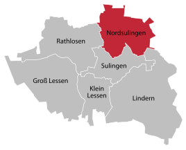
Location of Nordsulingen
|
|
Nordsulingen is a town in the town of Sulingen in the Diepholz district in Lower Saxony . Around 1340 inhabitants live in the district on an area of 15.48 km².
geography
North Sulingen is located in the north-eastern part of the city of Sulingen, 1 km north of the main town of Sulingen. The locality of Nordsulingen includes Bocksgrund, Hassel, Langenäse, Nechtelsen, Nordsulingen, Thiermann and Vorwohlde.
Neighboring towns are - clockwise from the north - Schwaförden , Ohlendorf , Maasen , Lindern , Sulingen , Rathlosen and Anstedt .
The Sule flows through northern Sulingen .
history
Since the regional reform , which came into force on March 1, 1974, the previously independent municipality of North Sulingen has been one of five localities in the city of Sulingen.
politics
Local mayor is Maik Borchers (WGN). Wilhelm Nuttelmann (WGN) held the office until 2016.
Culture and sights
- In the district competition “ Our village has a future ”, the district of Nechtelsen came first in the special competition for farmers and hamlets in 2008.
- In the district of Nechtelsen, on the grounds of the “ Sulinger Land water supply ”, there is a fountain that the Sulingen artist Robert Enders designed in 1982 from concrete and natural stone.
Economy and Infrastructure
North Sulingen is far away from major traffic. The federal motorway 1 runs 43 km to the west. The federal highway 61 leading from Bassum via Sulingen (Kernort) and Uchte to Minden runs to the west, 1.5 km away. The federal highway 214 from Diepholz via Sulingen (Kernort) to Nienburg runs south in a distance of 2 km.
In North Sulingen - in contrast to some of the smaller districts of Sulingen - there are street names and not just house numbers , so that residents, postmen, suppliers and visitors can find their way around.
Individual evidence
- ^ Federal Statistical Office (ed.): Historical municipality directory for the Federal Republic of Germany. Name, border and key number changes in municipalities, counties and administrative districts from May 27, 1970 to December 31, 1982 . W. Kohlhammer GmbH, Stuttgart and Mainz 1983, ISBN 3-17-003263-1 , p. 189 .
- ^ Local councilor North Sulingen


