
Molasse basin

In the regional geology of the Alpine countries, the area on the northern edge of the Alps occupied by molasse sediments is called the molasse basin , also known as the foothills of the Alps . The term molasse basin is also generally used to refer to a sedimentary basin that absorbs the weathering debris from a rising mountain range.
The north alpine molasse basin treated here is subdivided into a larger northern area, the foreland molasse with rocks in mostly undisturbed storage, and a narrower southern area directly on the northern edge of the Alps, the subalpine molasse (molasse zone, folded molasse) with scaly and steeply positioned molasse rocks.
Geographical location
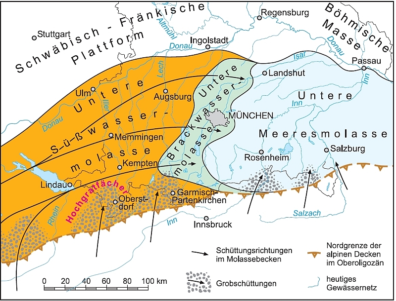
The Molasse Basin lies in front of the entire northern Alpine front. It extends over parts of France , Switzerland , Germany and Austria with a length of about 1,000 km . At its western end on Lake Geneva , bounded to the north by the Folded Jura , it is around 20 km wide. Further to the east, it reaches increasingly to the north and reaches its greatest width of almost 130 km in the Bavarian foothills of the Alps , at the "bend" of the Franconian Alb . From there, the width of the Molasse basin, now limited to the north by the Bohemian Massif, decreases again in an easterly direction and reaches around 10 km at the level of Amstetten in Lower Austria . From there, the basin stretches as a narrow strip to around St. Pölten , then widens again - pivoting in a north-easterly direction - to a width of around 40 km, and merges north of the Danube into the Carpathian pre-depth . Geologically and morphologically, in this transition area it is also connected to the Pannonian Plain via the Vienna Basin .
Emergence


The Molasse Basin lies in a foreland or marginal depression that formed in the final phase of the formation of the Alps in front of the Alps, when the European continental plate bent down under the weight of the mountainous body on top. This foreland depression was initially a relatively narrow arm of the sea ( Molasse Sea ), which quickly filled with sediments and silted up. Then the earth's crust sank again to such an extent that the molasse basin was in contact with the surrounding ocean areas. This is supported by the shark faunas, which can be found in many places, for example in the Erminger Turritellenplatte near Ulm and in the Swiss Mittelland. The Molasse Sea is palaeogeographically assigned to the so-called Paratethys , which emerged from the Mesozoic Tethys Ocean .
In the course of the Tertiary, rivers transported large amounts of erosion material from the rising Alps into the foreland basin. With the exit of the rivers from the Alps into the flat regions, the flow speed generally decreased sharply. Therefore, near the edge of the Alps, the coarsest material was deposited in the form of extensive pouring compartments, because this could no longer be carried along as alluvial debris by the transporting medium, the water. From this gravel and coarse sand , conglomerates (e.g. Nagelfluh ) and coarse sandstones emerged , which especially shape the freshwater molasses. A prominent example of such a pouring fan is the Napfbergland in the Swiss Plateau . Smaller grain sizes, on the other hand, could be transported far into the basin as suspended matter and formed clayey or marl-like sediments, which are especially typical of sea molasses. Times of low erosion activity are reflected in layers with overall smaller grain sizes. In the foreland close to the Alps, depending on the region, a molasse sequence that is up to 4000 m thick was created, which is divided into numerous sub-units. Often the molasses sediments contain remains of plants and other organic residues.
Surface shapes
In the foreland molasse, the molasse basin is characterized over long stretches by gentle hills and wide hollow valleys. In Switzerland, the central plateau has significantly greater differences in altitude than the Bavarian and Austrian Alpine foothills .
In the Subalpine Molasse, long ridges with inclined conglomerate ribs run parallel to the Alps; their ridges are mostly rounded and have no rugged rock faces.
The south of the Molasse Basin was shaped by the glaciers of the Ice Ages , which created a multitude of Ice Age surface forms ( glacial series ) with tub-shaped valleys and elongated ridges.
The river network is directed away from the Alps, only at the northern edge of the foreland molasse does the Danube lead most of the rivers east to the Black Sea . West of the source of the Danube, the Rhine and its tributaries, especially the Aare , drain the foreland molasse to the North Sea . The extreme western end is drained to the west and the Mediterranean by the Rhone and some of its tributaries .
Sequence of layers
The rocks of the Molasse Basin were deposited in the Upper Eocene to the Upper Miocene . They are divided into four main groups based on the prevailing deposit conditions - marine or terrestrial :
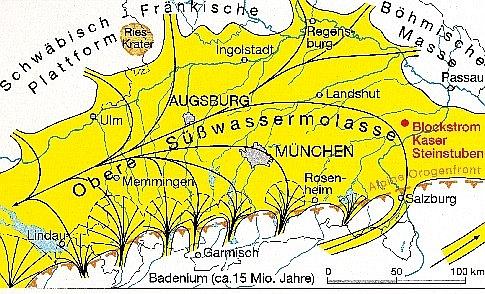
- Upper freshwater molasses (abbreviation OSM or tOS), Serravallium , Tortonium and Pontium , about 16 to 5 million years ago
- Upper marine molasses (OMM, tOM), Burdigalium and Langhium , about 22 to 16 million years ago
- Lower freshwater molasses (USM, tUS), Chattium and Aquitanium , about 28 to 22 million years ago
- Lower marine molasses (UMM, tUM), rupelium , about 34 to 28 million years ago
In the eastern molasse basin, the lower freshwater molasse changes into marine layers. It is referred to there as the younger part of the Lower Sea Molasse, the Lower Freshwater Molasse, which is represented in the west, is missing.
raw materials
Foreland basin of orogenic are, if they have a climate that lush plant growth enables typical training rooms for coal . The Molasse Basin also has coal deposits ( lignite ) in quantity and quality that allowed profitable mining at least in the 20th century, for example pitch coal in southern Upper Bavaria and lignite in the Upper Palatinate lignite mining district and Hausruck in Upper Austria. The more coarse-plastic and thus relatively porous and permeable molasse sediments are also suitable as storage rocks for crude oil and natural gas , and the molasse basin actually has some such deposits. However, some of the hydrocarbons are also located below the actual filling of the basin in layers of the Mesozoic era . The barley sands in the northwest of the basin contain brown ore . Molasse sandstone was used as a building material in numerous regions, including the Bernese Sandstone (OMM), the most important quarry of which is located in Ostermundigen near Bern.
museum
The Augsburg Nature Museum is mainly dedicated to molasses.
Remarks
Literature and maps
- Geological map of Switzerland 1: 500,000 . Swiss Geological Commission, 1980.
- Hans Heierli: Geological hiking guide Switzerland. Part 1: The geological basics . 2nd Edition. Ott, Thun 1983, ISBN 3-7225-6282-1 .
- Geological map of Bavaria 1: 500 000 with explanations . 4th edition. Bavarian Geological State Office, Munich 1996.
- Geological overview map of the Republic of Austria with tectonic breakdown 1: 1,000,000 . Revised reprint. Geological Federal Institute Vienna, Verlag Freytag & Berndt and Artaria, Vienna 1986.
- Volker J. Sach: Fossil catalog of the Miocene molasses in southwest Germany . Documenta naturae. Special volume 70, Munich 2014, ISBN 978-3-86544-570-4 ( online ).
Web links
- The molasse basin at the time of the Upper Oligocene (lower sea molasses, brackish water molasses, lower fresh water molasses 28–23 million years) (image file)
- The Molasse Basin at the time of the Miocene (Upper Freshwater Molasse 23-5.3 million years) (image file)
- Website of the scientific association for the exploration of the alpine molasse basin (English)
Individual evidence
- ^ Fritz Schlunegger: Geology and Geomorphology of the Entlebuch - a small landscape history. Entlebucher Brattig. No. 24, 2006, pp. 98–99 ( PDF 850 kB)
- ↑ Explanations of the Geological Map of Bavaria 1: 500000, p. 144
- ↑ Barbara Meller: The facies of the lignite-bearing Upper Miocene sediments of the Hausruck (Molasse Basin, Upper Austria) based on paleobotanical-paleoecological studies. P. 113–132 in: Hans Egger, Christian Rupp (Red.): Contributions to the geology of Upper Austria. Working conference of the Federal Geological Institute 2007, Linz, 7.-11. May. Federal Geological Institute, Vienna 2007, ISBN 978-3-85316-035-0 ( PDF 1.6 MB).
- ↑ Bruno Bertleff, Joris Ondreka, Hans Plum, Roman Storz, Wilhelm Schloz, Matthias Selg, Christian Trapp: Hydrocarbon deposits in the regional association Bodensee-Oberschwaben - distribution, occurrence and exploration. Annex 26 to: Explanations of the project Provision of hydrogeological and geothermal basics for the use of deep geothermal energy / hydrogeothermal energy in the Lake Constance-Oberschwaben region. Regional Council Freiburg i. Br., Dept. 9, State Office for Geology, Raw Materials and Mining (LGRB), 2005 ( PDF 480 kB).
- ^ Robert Janoschek: Oil and natural gas in Upper Austria. P. 91–107 in: W. Podzeit, F. Steininger (Ed.): Geology and Paläontologie des Linzer Raumes. Upper Austrian State Museum, Linz 1969 ( PDF 18.6 MB).
- ↑ Dirk Dethleff: Swiss sandstone - geology, mining and use. NaturBau Stein, January 2001, pp. 6-7 ( PDF 510 kB, entire issue).
- ↑ Fritz Drevermann: Seas of primeval times. Verlag Julius Springer, Berlin 1932, p. 163 (Google Books)
Coordinates: 47 ° 46 ′ 7.9 ″ N , 10 ° 8 ′ 25.4 ″ E