
Obersaida artificial moat
| Obersaida artificial moat | ||
 The course of the Obersaida artificial moat in front of the dam of the Obersaida artificial pond |
||
| Data | ||
| location | Saxony , Germany | |
| River system | Elbe | |
| source | Discharge at Obersaidaer artificial pond 50 ° 46 ′ 17 ″ N , 13 ° 20 ′ 4 ″ E |
|
| muzzle | in the upper Großhartmannsdorfer pond Coordinates: 50 ° 46 '52 " N , 13 ° 19' 31" E 50 ° 46 '52 " N , 13 ° 19' 31" E
|
|
| length | 3 km (of which approx. 0.9 km has disappeared) |
|
The Obersaidaer Kunstgraben is an artificial ditch between the town of the same name Obersaida and Großhartmannsdorf in the Ore Mountains from the 18th century. It was built for the purpose of forwarding impact water to the Freiberg mountain area and is part of the Freiberg district water run facility .
course
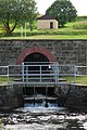
The Obersaida artificial ditch begins below the dam of the Obersaida artificial pond (built 1728–1734) at 544 m above sea level. HN . Here the Dörnthaler Kunstgraben flows at right angles a few meters next to the Barthelschütz , which runs parallel to the dam of the artificial pond for the last few meters. Under this rifle house, water can be chipped off into the Saidenbach via a short ditch .
The artificial ditch runs off at right angles from the dam towards the state road 215 ( Oederan - Sayda ), which it crosses after about 150 meters. At this point there is an information board about the system of the Revierwasserlaufanstalt. The artificial moat continues on the right slope of the Saidenbach valley past some farmsteads towards the west. At the point where the federal road 101 passes the contour line of 440 meters, it crosses under this road in an arc and swings to the north. After about 600 meters the artificial ditch reaches the mouth of a rose (started in 1590), which leads the artificial ditch through the watershed line of Flöha and Freiberg Mulde . The upper mouth of the Mittelaidaer Rösche is located north of Mittelaida , near the headwaters of a tributary to the Saidenbach.
The water of the artificial ditch is led in this rose about 900 meters below the federal highway 101 in a north-easterly direction to the upper Großhartmannsdorfer pond . Here is the lower rose mouth hole at about 435 m above sea level. HN. On the Großhartmannsdorf side , its water flow is fed to the upper Großhartmannsdorf pond in an estuary that is only a few meters long and enclosed by walls. The Obersaidaer artificial ditch ends at this confluence. The Obere Großhartmannsdorfer Teich gives off its water to the Kohlbach-Kunstgraben for the Freiberg mining region .
history
Because the Obere Großhartmannsdorfer pond was built near a watershed line, the volume of the surface water flowing into it was initially unsatisfactory. For this reason, the successors of Martin Planer created the Obersaidaer artificial ditch so that additional water could be obtained from the catchment area of the Saidenbach for the mine pond. With regard to the time data, there are slightly different information in the literature. Wagenbreth and Wächtler give the period from 1592 to 1607 for the construction of the artificial trench and the period from 1603 to 1607 for the Central Aidaer Rösche.
Picture gallery

Outflow from the Obersaida artificial pond

Schützhaus am Kunstgraben below the Obersaidaer artificial pond
Rose mouth hole at the Upper Großhartmannsdorfer Pond


Individual evidence
- ^ A b c Otfried Wagenbreth , Eberhard Wächtler (ed.), A. Becke et al .: Der Freiberg mining. Technical monuments and history . Deutscher Verlag für Grundstofftindustrie , Leipzig, 1986, p. 63
- ^ A b Reichsamt für Landesaufnahme , Landesaufnahme Sachsen: Meßtischblatt 116, Lengefeld . Giesecke & Devrient , Leipzig 1927
- ^ Wagenbreth, Wächtler, 1986, pp. 63, 145
- ^ Reichsamt für Landesaufnahme , Landesaufnahme Sachsen: Meßtischblatt 5246, Sayda . Giesecke & Devrient , Leipzig 1913, individual supplements 1930
- ^ Wagenbreth, Wächtler, 1986, p. 67
Web links
- State dam administration of the Free State of Saxony (Ed.): The Freiberg Revierwasserlaufanstalt . Leaflet of the state dam administration, Free State of Saxony, at www.publikationen.sachsen.de