
Oconaluftee Valley
| Oconaluftee Archeological District | |||
|---|---|---|---|
| National Register of Historic Places | |||
 Oconaluftee River in the Great Smoky Mountains National Park |
|||
|
|||
| location | Cherokee , North Carolina | ||
| Coordinates | 35 ° 30 ′ 56 " N , 83 ° 18 ′ 19" W | ||
| NRHP number | 82001715 | ||
| The NRHP added | 19th February 1982 | ||

Oconaluftee is a river valley in the Great Smoky Mountains in North Carolina , in the southeastern United States . The former Cherokee village and parish in the Appalachian Mountains in the valley floor are now the main gateway to the Great Smoky Mountains National Park in North Carolina. The Oconaluftee area runs along the Oconaluftee River , which extends from Smokemont in the north to the southern end of the Qualla Boundary . The Qualla Boundary forms the largest part of the state land trust , which acts as a reservation for theEastern Band of Cherokee Indians serves. The national park area in the Oconaluftee Valley is home to the Oconaluftee Visitor Center, Mingus Mill and the Mountain Farm Museum . Much of the area is part of the Oconaluftee Archaeological District , which is listed on the National Register of Historic Places .
geology

Near Newfound Gap , a series of small streams and springs form the Beech Flats Prong . This flows south along the southern base of Mount Kephart , falls over 16 kilometers around 600 meters before it joins the Kephart Prong, Kanati Fork and Smith Branch to form the Oconaluftee River. The Oconaluftee flows further south, cutting a valley between the Richland Mountain Massif in the east and the Thomas Ridge Massif in the west. The confluence with the Bradley Fork at Smokemont significantly increases the amount of water, resulting in a widening valley. Near the border of the park, a larger plain has formed through the confluence with the Raven Fork, which comes from the northeast. After Cherokee, the river turns west on its way to its confluence with the Tuckasegee River near Bryson City .
The rock formations below the area around the confluence of the Oconaluftee and Raven Fork are the oldest exposed rocks in the eastern United States. The formation, which arose predominantly from orthogneiss in the Precambrian , was formed over a billion years ago by marine sediments and igneous rocks . At higher altitudes in the valley, the rock formations consist of metamorphic rock from the late Precambrian. This rock formed from marine sediments 400 million years ago when the North American and African plates collided and the Appalachians formed. The Greenbrier Fault crosses the Oconaluftee River between Tow String Creek and Mingus Creek and divides the base rock from the late Precambrian formation. Both rock layers are visible along US Route 441 between Newfound Gap and Cherokee.
history
Early history

The Cherokee considered the waters of the Oconaluftee sacred. Dora Woodruff Cope, who lived in the Oconaluftee Valley around 1900, recalled a legend her Cherokee neighbors told her:
... part of the river was called Ya'nu-u'nata wasti'yi, "Where the bears wash." It was a deeper part of the river, where all the animals came to wash and heal their wounds when they had been hurt by hunters. No white person had ever seen this place because evil had blinded us to its existence. The animals knew how to find it, and diving into it meant instant healing.
... part of the river was called Ya'nu-u'nata wasti'yi, "Where the bears wash." It was a deeper part of the river where the animals came to wash and heal their wounds inflicted on them by the hunters. No white person has ever seen this place because evil has blinded us to this place. The animals knew how to find the place, and immersing yourself there meant instant healing.
The term Oconaluftee was derived from the name of the Cherokee village Egwanulti , which means something like the river , and also appears in John Bartram's diaries of 1775. Exactly where the village was is unknown, although the anthropologist James Mooney assumed it was located near what is now Birdtown, between Cherokee and Bryson City. Archaeological evidence has shown a Cherokee settlement on Oconaluftee, north of the Qualla Boundary, just inside today's national park. Although the Cherokee lived throughout the Smoky Mountains, this is the only known permanent Cherokee settlement within the park. The village was probably destroyed by General Griffith Rutherford's army in 1776 during the American Revolutionary War.
19th century


John Jacob Mingus (approx. 1774–1852), who arrived at Oconaluftee in the 1790s, was the first Euro-American settler in the valley and the first to settle within the boundaries of today's national park. Mingus acquired the land from Felix Walker , a land speculator and later member of Congress in North Carolina. Mingus moved through the southern Appalachians, while his descendants stayed in the area until the park opened.
Mingus was followed by Abraham Enloe (1770–1840), who settled downstream from the Mingus. Thanks to his striking resemblance to Abraham Lincoln , many locals believed he was the president's father. Later Euro-American settlers were Isaac Bradley (1772–1855), whose family lived near the river that bears his name today, and Aden Carver (1844–1945), who lived near Smokemont.
In 1831 Enloe founded the Oconaluftee Turnpike Company with William Holland Thomas (1805-1893) in order to expand the Indian Gap Trail from Oconaluftee to the ridge of the Smokies into a road and to reach the saltpeter mines on Mount Le Conte . The road's first tax collector, Robert Collins, later led Arnold Guyot on expeditions to the peaks of the Smokies. Mount Collins , between Clingman's Dome and Newfound Gap, was named after him.
Thomas, son of white parents, was adopted by Chief Yonaguska and took control of Cherokee economic affairs in the 1830s. His land purchases for the tribe included the Qualla Boundary, which became the basis of state trusts for the Cherokee. After the New Echota Treaty of 1835, which sealed the Cherokee's removal from all eastern territories, Thomas went to Washington, DC and successfully argued that the Cherokee, as landowners, were citizens of North Carolina and that the treaty did not affect them. In 1868 the Eastern Band was recognized as a separate tribe.
20th century
In the late 19th century, inventions like the band saw and the forest railway led to a boom in the timber industry in the southern Appalachians. With base camps in Smokemont, the Three M Lumber Company and later the Champion Fiber Company struck large swaths of the forest in the Oconaluftee Valley before the Great Smoky Mountains Park Commission bought their contracts in the 1930s. In 1925, a devastating forest band destroyed the dry remains of the logging and scorched the slopes of the Smoky Mountains.
After the establishment of the national park, a Civilian Conservation Corps (CCC) camp was set up in Smokemont to build roads and hiking trails. In 1937, the CCC restored the Mingus Mill, a large, turbine-operated flour mill on Mingus Creek. In the 1950s, a number of wooden structures were relocated to an area adjacent to the visitor center to create the Mountain Farm Museum, which is dedicated to the lives of the pioneers in the Appalachians.
Today's structure


Together with the historical buildings in the area of the Oconaluftee visitor center, the valet service maintains a large campsite at the former lumberjack camp near Smokemont. The small mountain village Tow String is located between the national park and the Qualla Boundary above the valley. The southern section of the Blue Ridge Parkway meets the southern end of the valley, near the confluence of the Oconaluftee and Raven Fork.
A 32-kilometer junction of the Mountains-to-Sea-Trail connects Oconaluftee with the Appalachian Trail near the summit of Clingmans Dome . The Bradley Fork Trail follows the Bradley Fork to the plains between Hughes Ridge and Richland Mountain. From Charlies Bunion the Dry Sluice Gap Trail follows north to the ridge line of the Smokies,
In 1982 the valley was added to the National Register of Historic Places as the Oconaluftee Archaeological District .
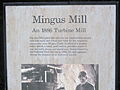
Mingus Mill
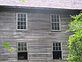
Mingus Mill (Eng. Mingus Mill) was built in 1886 by mill builder Sion Thomas Early from Sevier County , Tennessee . Early took over the work for John Mingus, a son of John Jacob Mingus. Early completed the mill in three months at a cost of $ 600. The mill worked in wholesale and retail until it was taken over by the National Park Service in 1934. The mill was restored in 1937, remained closed during World War II and reopened in 1968. Aden Carver, who arrived in Oconaluftee in the 1850s, helped Early build the mill in 1886. When the mill was restored in 1937, the 90-year-old Carver helped rebuild it.
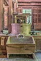
The two turbines that generate the energy for the mill are powered by water; the water is fed from Mingus Creek to the turbines via a canal and wooden gutters. An iron bar connects the turbines with the millstones on the ground floor, the grain cleaner and a screening plant on the first floor. Wheat or corn is first fed to the grain cleaner via a conveyor belt , which essentially consists of a fan that separates the grain from dirt or other impurities. It then falls back to the ground floor and is brought to the millstones, which grind it into flour or cornmeal. The flour is then brought back to the first floor and separated into the different grinds by different fabrics. Although the turbines are not as photogenic as the classic externally mounted mill wheels such as the one at the Cable Mill in Cades Cove , the turbines are much more efficient than the mill wheels and require less water to operate.
Oconaluftee Visitor Center
The original visitor center in Oconaluftee was built in 1940 by the CCC as a station for the park rangers and as a courtroom for the magistrate. The building made of wood and stone was only to serve as a temporary visitor center from 1947, but the new visitor center with two buildings was only completed in 2011 and inaugurated on April 15. The Great Smoky Mountains Association paid $ 3 million for the center and plumbing, and the Friends of the Smokies donated another half a million for the exhibition in the visitor center. Trotter & Associates Architects, LLC were the architects responsible for the construction. No public funds were used for the project, so all costs were covered by the two groups and the buildings were then donated to the park. The visitor center is open year round, and after 64 years of "temporary" use, the original building has been given its purpose. Directly to the south is the southern end of the Blue Ridge Parkway , which, unlike the park and visitor center, is usually closed in winter.
Mountain Farm Museum
The Mountain Farm Museum is right next to the visitor center. The museum is a collection of various wooden buildings from different parts of the park. The purpose is to depict a typical mountain farm of the early settlers in the Appalachians. During spring and summer, the gardens are planted and poultry roam the grounds. Since most of the buildings could not be moved completely intact, they cannot be entered on the National Register of Historic Places , but the buildings are maintained by the valet service according to the rules for monument preservation.
Mountain Farm Museum building:
John Davis Cabin , built in 1900. This cabin originally stood on Indian Creek several miles to the west and above Bryson City. The builder John Davis moved to the area in 1885 to keep his cattle outdoors . The hut was built with matching walnut trunks and put together with dovetail connectors.
Enloe Barn a barn that was built by Abraham Enloe's grandson Joseph around 1880. He was also the owner of the property on which the museum is now located. The Enloes sold their farm to the Floyd family in 1917. This relatively large barn housed cattle on the lower floor and grain and fodder on the upper floor. This is the only building that was originally located in the valley and it has only been moved around 180 meters from its location. The roof consists of over 16,000 hand-split shingles.
Messer Applehouse , built by Will Messer in the Cataloochee Valley , a valley that lies within the national park on the other side of Cataloochee Mountain to the east. In its original location, the building was partially underground to insulate it from the winter cold and summer heat.
The Meathouse , directly behind the cabin, also comes from the Cataloochee Valley. To make meat, especially pork, more durable and tasty, it was smoked in the meat shop.
The Baxter / Jenkins Chickenhouse , a chicken house built by Willis Baxter in the late 19th century. The previous location was at the foot of the Maddron Bald between Greenbrier and Cosby (Tennessee) . The associated Baxter hut is still in the old place.
The Blacksmith shop , a forge, was built in Cades Cove around 1900.
The Springhouse was moved from the Cataloochee Valley and served to cool food.
Two corn cribs , built around 1900, were brought to the museum grounds by the Thomas Divide north of Bryson City. The roof of the grain cribs could be removed to bring in the harvest, the smaller quantities for the mill were taken through small, square windows in the side wall.
Other buildings in the museum include a pig pen , millet press , soap boiler , wooden shed and original fences from the region.
Oconaluftee Indian Village
The Oconaluftee Indian Village (dt. Oconaluftee Indian Village ) is operated by the Cherokee Historical Association on the slopes of Rattlesnake Mountain within the Qualla Boundary. The open-air museum is a replica of a typical Cheroke village from the mid-18th century.
gallery
Mingus Mill
Historical description

Mill and gutter

Gutter
Exterior view of the mill
Functional flour mill

Upper floor of the mill


Web links
- National Park Service: Mountain Farm Museum and Mingus Mill
- Smokies Information: Great Smoky Mountains Association - Nonprofit partner organization
- Cherokee NC: Oconaluftee Indian Village
Individual evidence
- ^ Harry Moore: A Roadside Guide to the Geology of the Great Smoky Mountains National Park University of Tennessee Press, 1988, pp. 45, 101.
- ^ Harry Moore: A Roadside Guide to the Geology of the Great Smoky Mountains National Park University of Tennessee Press, 1988, 23-27.
- ^ Harry Moore, A Roadside Guide to the Geology of the Great Smoky Mountains National Park University of Tennessee Press, 1988, p. 32.
- ↑ Harry Moore: A Roadside Guide to the Geology of the Great Smoky Mountains National Park University of Tennessee Press, 1988, pp. 98-101.
- ↑ a b Florence Cope Bush: Dorie: Woman of the Mountains , University of Tennessee Press, 1992, p. 18.
- ^ William Bright: Native American placenames of the United States , University of Oklahoma Press, 2004, ISBN 978-0-8061-3598-4 p. 343
- ^ A b James Mooney: Myths of the Cherokee and Sacred Formulas of the Cherokee Charles Elder, 1972, p. 517.
- ^ Carson Brewer: Great Smoky Mountains National Park , Graphic Arts Center Publishing, 1993, p. 18.
- ↑ James Mooney: Myths of the Cherokee and Sacred Formulas of the Cherokee , Charles Elder, 1972, p. 49.
- ^ Daniel Pierce: The Great Smokies: From Natural Habitat to National Park University of Tennessee Press, 2000, p. 9.
- ↑ Michael Frome: Strangers In High Places: The Story of the Great Smoky Mountains University of Tennessee Press, 1994, p. 107.
- ^ Vicki Rozema: Footsteps of the Cherokees John F. Blair Publisher, 1995, pp. 58-60.
- ↑ Michal Strutin: History Hikes of the Smokies Great Smoky Mountains Association, 2003, pp. 125, 325.
- ↑ Information in this section obtained from interpretive signs provided by the National Park Service at the Mingus Mill site, July 2007.
- ↑ Unless otherwise stated, the following information comes from: Tom Robbins: Mountain Farm Museum Self-Guided Tour Great Smoky Mountains Association.
- ^ Ed Trout: Historic Buildings of the Smokies Great Smoky Mountains Association, 1995, p. 12.
- ↑ George Ellison: Mountain Farm Museum Celebrates 50th Anniversary in Smoky Mountain News of May 21, 2003. Retrieved: August 18, 2007.
- ^ Ed Trout: Historic Buildings of the Smokies Great Smoky Mountains Association, 1995, p. 47.
- ↑ Michal Strutin: History Hikes of the Smokies Great Smoky Mountains Association, 2003, pp. 264-266.