Ogunquit
| Ogunquit | ||
|---|---|---|
|
Location in Maine
|
||
| Basic data | ||
| Foundation : | 1980 | |
| State : | United States | |
| State : | Maine | |
| County : | York County | |
| Coordinates : | 43 ° 15 ′ N , 70 ° 36 ′ W | |
| Time zone : | Eastern ( UTC − 5 / −4 ) | |
| Residents : | 892 (as of 2010) | |
| Population density : | 84.2 inhabitants per km 2 | |
| Area : | 11.1 km 2 (about 4 mi 2 ) of which 10.6 km 2 (about 4 mi 2 ) is land |
|
| Height : | 43 m | |
| Postal code : | 03907 | |
| Area code : | +1 207 | |
| FIPS : | 23-54980 | |
| GNIS ID : | 0582646 | |
| Website : | www.townofogunquit.org | |
Ogunquit is a city in York County, Maine in the United States . In 2010 it had 892 inhabitants. With the motto "Beautiful Place by the Sea", Ogunquit is a popular summer resort with an above-average concentration of lesbian and gay guests . Ogunquit forms part of the metropolitan area of Portland .
geography
According to the United States Census Bureau , the city has a total area of 11.1 km² , of which 10.6 km² is land and 0.5 km² (= 4.43%) is water. The place is right on the Atlantic Ocean . The US Highway 1 leads as Main Street in the north-south through the city. The Maine Turnpike ( Interstate 95 ) is a toll road a little further from the coast .
The north of Ogunquit and its surroundings are drained by the Ogunquit River . The Josias River flows into the south of the urban area .
history
Ogunquit, whose name means "coastal lagoon" in the Abenaki language , was first a settlement within the village limits of Wells , which was settled in 1641. The first sawmill was built in 1686 and operated along the ebb and flow of the Ogunquit River. Shipbuilding . Aside from schooners and brigs , local shipbuilders built the famous "Ogunquit dory ".
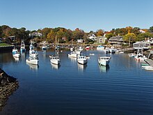
In the area that was then called Fish Cove, near the non-navigable Josias River, fishing was the main source of income. However, the bay was not protected from Atlantic storms by headlands or breakwaters , so fishermen had to protect their boats by carrying them ashore every evening. To create a safe anchorage, they formed the Fish Cove Harbor Association and dug a canal over land to connect Fish Cove to the Josias River. When the trench was finished, sea water seeped in and erosion helped widen the passage. The resulting ebb and flow basin was named Perkins Cove. A hand-operated drawbridge for pedestrians spans the mouth of the basin, which is one of the most photographed sites of the State of Maine. The old village was discovered by artists because of its approximately five kilometers long beach made of light sand and dunes that form a barrier peninsula, which in turn is connected to the mainland by a bridge over the Ogunquit River, built in 1888 . It became a popular artists' colony and tourist destination. Particularly after 1898, when the Ogunquit Art Colony was founded, it was by no means uncommon to see artists and fishermen doing their respective jobs around Perkins Cove. In order to be able to cope with the influx of visitors in summer, some large lake hotels were built. Ogunquit is also known for its hiking trail called the "Marginal Way". This stretches about two and a half kilometers along the rocky coast from Perkins Cove, a tourist shopping area to the south, to Ogunquit Beach near the center and is scenic.
Today Ogunquit is a lively resort. He gained independence from Wells in 1980. Visitors come from a great distance, some even from Canada .
Cultural places and museums
- Historical Society of Wells and Ogunquit (1862) (in Wells)
- Ogunquit Museum of American Art
- Ogunquit Playhouse
- Captain James Winn House (c. 1785)
Known residents
- John Kendrick Bangs (1862-1922), writer
- Walt Kuhn (1877–1949), artist
- Rudolph Dirks (1877–1968), comic pioneer and painter
- Charles H. Woodbury, artist
Web links
Individual evidence
- ↑ Population data from the 2010 US Census in the American Factfinder
- ↑ Gay Ogunquit . Retrieved July 17, 2008
- ↑ Way " ( Memento of the original from January 22, 2008 in the Internet Archive ) Info: The archive link was automatically inserted and not yet checked. Please check the original and archive link according to the instructions and then remove this note .. Accessed March 22, 2008


