Without (rocker)
| Without | ||
|
Half-timbered houses on the river Ohne in Niederorschel |
||
| Data | ||
| location | Eichsfeld district , Thuringia ( Germany ) | |
| River system | Elbe | |
| Drain over | Wipper → Unstrut → Saale → Elbe → North Sea | |
| source | in Kallmerode in Eichsfeld | |
| Source height | approx. 370 m above sea level NHN | |
| muzzle | in the Wipper between Gernrode (Eichsfeld) and Bernterode Coordinates: 51 ° 23 '4 " N , 10 ° 26' 39" E 51 ° 23 '4 " N , 10 ° 26' 39" E |
|
| Mouth height | 268 m above sea level NHN | |
| Height difference | approx. 102 m | |
| Bottom slope | approx. 7.3 ‰ | |
| length | approx. 14 km | |
| Catchment area | 69 km² | |
| Medium-sized cities | Leinefelde-Worbis | |
|
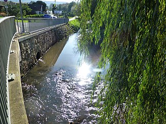
Bridge over the Ohne in Niederorschel |
||
The Ohne is an approximately 14 kilometers long right tributary of the Wipper in the north of Thuringia , Germany .
course
The Ohne rises in the Eichsfeld district at the foot of the Dün ridge . Its source is in Kallmerode in Eichsfeld . From there the Ohne flows in a predominantly eastward direction. In the case of effects , the river without is dammed up in the dam effects . After flowing through Niederorschel , it flows into the Wipper on the outskirts of this municipality between Gernrode and Bernterode .
Surname
The name of the brook cannot yet be explained. The only existing documentary evidence comes from the year 900 and is of indirect form (Gau Ohnfelt ). Also for the village of Ohne the origin of the name could not be clarified, so that the place name does not help either. Seems possible for the field names a derivation from the Primitive Indo-European to (breathe) or the Gothic anan (breathe, breathe).
Tributaries
- Griesgraben (R) at impact
- Ahlenbach (R) in Niederorschel
- Laubach (L) in Niederorschel
Economy and tourism
- Part of the Mühlenwanderweg Eichsfeld (Birkunger Stau - Rohrmühle - Bäckermühle - Mönchmühle - Eichmühle - Eckmühle - Obermühle - Aumühle - Wendelröder Mühle - Schwarzburger Mühle - Schwerdt'sche Mühle), the last three mills mentioned are on the Wipper.
Web links
Individual evidence
- ↑ a b Michael Bergemann: Complete list of flowing waters in the Elbe catchment area . Authority for Environment and Energy, Hamburg July 1, 2015 ( PDF; 802 kB [accessed on November 29, 2015]).
- ^ Thuringian State Institute for the Environment (ed.): Area and waterway key figures (directory and map). Jena 1998. 26 pp.
- ^ Franz Witt: Contributions to the knowledge of the river names of Northwest Germany . Printed by Schmidt & Klaunig, Kiel 1912.
- ↑ Elfriede Ulbricht: The river basin of the Thuringian Saale . 1st edition. Max Niemeyer, Halle (Saale) 1957, DNB 455149968 .


