
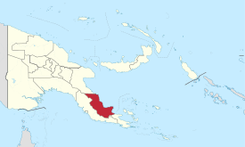
Oro Province
| Oro (Northern Province) |
|
|---|---|

|
|
| geography | |
| Country: | Papua New Guinea |
| Waters: | Pacific Ocean |
| Islands: | ( located in New Guinea ) |
| Geographical location: | 9 ° 0 ′ S , 148 ° 50 ′ E |
| Basic data | |
| Surface: | 22,800 km² |
| Residents: | 133,000 |
| Population density: | 6 inhabitants / km² |
| Capital: | Popondetta |
| Situation map | |
  |
|
Oro is one of the 21 provinces of Papua New Guinea and is located in the southeast of the country. It is about 22,800 km² and has around 133,000 inhabitants. The capital is Popondetta with 19,556 inhabitants (as of 2000). The neighboring provinces of Oro are the Central Province in the west and south, Milne Bay Province in the extreme southeast and Morobe in the north.
Oro lies between the sea and high mountains. The approximately 250 km long coast has little-visited, attractive beaches and many secluded bays. The hinterland rises slowly until the high mountain ranges with some four thousand meters are reached. The province has received little tourist attention, although it has a very good infrastructure and is well developed in terms of transport. Rubber trees and coffee are grown on the coast .
history
Oro was called Northern Province until the 1980s , although the province is not in the north of Papua New Guinea. But it was the northernmost province of the former Australian colony of Papua. Oro was neglected for a long time in the colonial era until gold was discovered and mined for a short time between the world wars .
During the Second World War , heavy fighting broke out in the province in the course of the Kokoda Track Campaign , with severe damage. After the war a new provincial capital was to be built with Higatura . Just as the new city was being built, a violent volcanic eruption of the Lamington broke out on January 21, 1951 , which completely destroyed the city and killed over 3,000 people. Today you can visit the peaceful crater from Popondetta , the new capital of the province, which was built at a greater distance from the volcano.
In November / December 2007, cyclone Guba caused severe damage in the province. 172 deaths and up to 13,000 people have been reported to have lost their homes.
population
The Orokaiva are among the better-known tribes of the province . This Melanesian tribe, who gave the province its name, are considered to be hardly belligerent and more interested in sorcery .
Districts and LLGs

The province of Oro is divided into two districts. Each district consists of one or more "areas at the local administrative level", Local Level Government (LLG) Areas , which are divided into Rural (rural) or Urban (urban) LLGs.
| District | Administrative center | Designation of the LLG areas |
|---|---|---|
| Ijivitari District | Popondetta | Afore rural |
| Cape Nelson Rural | ||
| Oro Bay Rural | ||
| Popendetta Urban | ||
| Sohe district | Kokoda | Higaturu Rural |
| Kira Rural | ||
| Kokoda Rural | ||
| Tamata Rural |
Footnotes
- ↑ Papua New Guinea: Cyclone Guba Emergency Appeal ( Memento of the original from July 23, 2010 in the Internet Archive ) Info: The archive link was inserted automatically and has not yet been checked. Please check the original and archive link according to the instructions and then remove this notice.
- ↑ See also the article Cyclone Guba in the English language Wikipedia .
- ^ National Statistical Office of Papua New Guinea
literature
- Heiner Wesemann: Papua New Guinea. Niugini. Stone Age Cultures on the Way to the 20th Century. DuMont, Cologne 1985, ISBN 3-7701-1322-5 ( DuMont culture travel guide in the series DuMont documents ). The Papuan Villager (German edition).
Bougainville | Central | Eastern Highlands | East New Britain | East Sepik | Enga | Gulf | Hela | Jiwaka | Madang | Manus | Milne Bay | Morobe | New Ireland | Oro | Sandaun | Simbu (Chimbu) | Southern Highlands | Western | Western Highlands | West New Britain | National Capital District (Port Moresby)