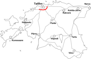
Põhimaantee 11
| Põhimaantee 11 in Estonia | |

|
|
| |
|
| map | |
| Basic data | |
| Operator: | Maanteeamet |
| Start of the street: |
Tallinn ( 59 ° 27 ′ N , 24 ° 55 ′ E ) |
| End of street: |
Keila ( 59 ° 19 ′ N , 24 ° 26 ′ E ) |
| Overall length: | 38.4 km |
The Põhimaantee 11 (National Road 11) is a highway in Estonia .
course
The road, also known as Tallinna ringtee (Tallinn Ring), bypasses the state capital Tallinn in the south and connects the Põhimaantee 1 to Narva , from which it branches off at the Peterburi tee in the east of Tallinn, the Põhimaantee 2 to Tartu , the Põhimaantee 4 to Narva Pärnu and Riga as well as Põhimaantee 8 to Paldiski , where it ends in Keila , and thus enables a bypass of the city outside the inner city area (which is mandatory for heavy traffic).
The length of the road, also designated as Europastraße 265 , is around 38 km.
Individual evidence
See also
Web links
Commons : Estonian national road 11 - Collection of pictures, videos and audio files

