
Parramatta River
| Parramatta River | ||
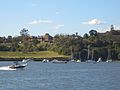
 Parramatta River from the Gladesville Bridge |
||
| Data | ||
| location | New South Wales , Australia | |
| River system | Parramatta River | |
| Drain over | Port Jackson → Tasman Sea | |
| source | Toongabbie Creek and Darling Mills Creek confluence 33 ° 47 ′ 56 ″ S , 150 ° 59 ′ 47 ″ E |
|
| muzzle | At Parramatta in Sydney Harbor Coordinates: 33 ° 51 ′ 7 ″ S , 151 ° 12 ′ 31 ″ E 33 ° 51 ′ 7 ″ S , 151 ° 12 ′ 31 ″ E |
|
| Mouth height |
0 m
|
|
| Catchment area | 130 km² | |
| Left tributaries | Lane Cove River | |
| Right tributaries | Duck River , Iron Cove Creek, Hawthorne Canal | |
| Big cities | Sydney | |
The Parramatta River is a waterway in Sydney , Australia . It is the most important tributary of the port of Sydney ( Port Jackson ) along with the smaller rivers Lane, Cove River and Duck River .
course
The river begins at the confluence of Toongabbie Creek and Darling Mills Creek west of Parramatta City and flows eastward to a line Greenwich Point ( Greenwich ) - Robinsons Point ( Birchgrove ). At this point, still 13 miles from the sea, it flows into Port Jackson .
The total catchment area of the river covers an area of approximately 130 km² and is considered an estuary up to the Charles Street Weir in Parramatta City, about 30 kilometers west of the Sydney Heads .
Tributaries
The tributaries of the Parramatta River are:
- Lane Cove River
- Hawthorne Canal
- Iron Cove Creek
- Powells Creek
- Haslams Creek
- Duck River
- Subiaco Creek
- Vineyard Creek
- Clay Cliff Creek
administration
The entire harbor of Sydney with all its tributaries is now subject to a long-term catchment management plan . The government has almost abolished local responsibilities through water management offices.
The New South Wales government has a set policy of public accessibility to the banks of the port and river. This also includes sections of the banks in private hands, which are freely accessible at low tide. Berths and marinas are the responsibility of NSW Maritime , which takes care of the operation of the port, the riverbed and the seabed. In some bays there are pontoon docks, mostly privately owned, but some also in connection with commercial docks.

Parramatta River at Five Dock Bay in Drummoyne
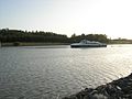
Parramatta River near Gladesville
Parramatta River at Ermington
Parramatta River at Parramatta City


traffic

Ferry service and moorings
The Parramatta River is serviced by River Cat ferries that run to Circular Quay . The main landing stages are:
- Parramatta City (south bank)
- Sydney Olympic Park , (south bank)
- Meadowbank , (north bank)
- Kissing Point , (north bank)
- Cabarita Park, (south bank)
- Abbotsford , (south bank)
- Five Dock , (south bank)
- Gladesville , (north bank)
River crossings

The Parramatta River, along with the harbor, is the main waterway in Sydney. Since the settlement by the European immigrants, the river and port have formed a perfect barrier for the development of the area north of it. You're cutting Sydney in half. Therefore, many river crossings are extremely important for city life. From east to west (including the port) these are:
- Sydney Harbor Tunnel
- Sydney Harbor Bridge
- Gladesville Bridge
- Mortlake Ferry (the last car ferry on the river)
- Ryde Bridge (now a double bridge)
- Old railway bridge in Meadowbank (now a pedestrian and bicycle bridge)
- John Whitton Bridge (new railway bridge)
- Silverwater Bridge
- Thackeray Bridge (pedestrian bridge) near the Rydalmere ferry terminal
- Carlingford Line railway bridge followed by a pipe bridge
- Bridge on James Ruse Drive
- Gasworks Bridge in Parramatta (historic iron lattice bridge named after the earlier gas works)
- Bridge of Oars in Parramatta
- Barry Wilde Bridge in Parramatta
- Lennox Bridge in Parramatta

John Whitton Bridge in Meadowbank

Silverwater Bridge

Gasworks Bridge in Parramatta

Bridge of Oars in Parramatta


Ecology and environment
Water quality
Until 1970 the river and harbor served as open sewer ditches for Sydney's industry and so the bays on the south bank of the middle reaches are polluted with various heavy metals and chemicals. The bays on the north bank are not as badly affected as the Sydney Harbor Bridge was not completed until 1932 and so the industry settled more on the south bank of the harbor.
Dr. Gavin Birch of the University of Sydney has published a number of documents showing that Sydney Harbor is just as polluted as most other ports in industrial cities, that most of the debris is in the bays on the south bank of the central reaches (Blackwattle Bay and Homebush Bay ) find that there are five particularly polluted areas in Sydney Harbor and that four of them are in the Parramatta river system.
The most polluted areas on the Parramatta River are:
- Homebush Bay - Dioxins , lead , phthaleate , DDT , PAK (coal tar), especially from the nearby chemical plants of Berger Paints , CSR Chemicals Ltd. , ICI / Orica and Union Carbide .
- Iron Cove - various metals and chemicals with no identifiable source. The pollution may be coming from Iron Cove Creek or the Hawthorne Canal .
- In front of the site of the former Australian Gas Light Company (AGL), now renovated as Breakfast Point .
The water quality is monitored for fecal and E. coli pollution by the New South Wales Environmental Protection Agency , but only to Cabarita westward. The authority does not examine the water quality in the river sections to the west, although other industrial companies have settled there and the river is used by leisure boats. In the monitored areas, the water quality is generally satisfactory, except after heavy rain.
fishing
There are various fishing bans on the Parramatta River due to the known pollution. Fishing is completely prohibited in Homebush Bay because of the dioxin, and commercial fishing is prohibited in the entire port area and all tributaries, including the Parramatta River.
The Parramatta River is one of the few coastal rivers of note in New South Wales that has not been subjected to the Healthy Rivers Commission Investigation . The Cooks River and Botany Bay have already been explored. Some people also request such an investigation for the Parramatta river system, so that all information about the state of the river and its deposits, as well as its fish population, is collected and thus supports water management management.
Important wetlands and other protected areas
Important wetlands are:
- Bicentennial Park Wetlands
- Newington Wetlands
There are significant settlements of mangroves on the river west of Henley (on the north bank) and Mortlake (on the south bank), as well as in the Lane Cove River . The mangroves have reclaimed land that was previously a salt marsh . Examination of historical drawings and descriptions shows that at the time of British colonization, the mangrove areas were smaller. Information boards in Glades Bay show that where extensive mangrove settlements can be found today, there used to be open water, sandy beaches and rocks. The clearing and cultivation of the land has ensured that soil and nutrients have been washed into the river. This created an ideal habitat for mangroves. The excessive silting of the river is a growing problem.
Land reclamation
Many areas on the river, especially the swampy headlands, were drained , often serving as landfill and later turned into playgrounds. Large parts of Meadowbank Park were created in this way. Many industrial areas were also wrested from the river, particularly in Homebush Bay. Most of the streams that flow into the bays have been canalized, i.e. H. Concrete embankment and stream bed.
Redevelopment
Many river areas with heavily contaminated deposits have not yet been remediated, but such work is just beginning in Homebush Bay. This concerns the dioxin deposits at the former Union Carbide factory and the lead deposits at the former Berger Paints factory. The former AGL location was analyzed and a redevelopment plan worked out and approved. The plan was carried out and the construction of medium and tall apartment buildings began. But the AGL-derived debris has not yet been adequately cleared, as independent studies show.
In other river areas, the debris was covered with concrete to protect the fish that feed on the bottom flora and fauna . Many of these companies are advocating leaving the toxic debris untouched, but environmentalists have warned that it could end up in the food chain and claim that the companies only want to save on the cost of cleaning.
free time activities
sailing
There are several sailing and yacht clubs on the river:
- Abbotsford 12ft Flying Squadron in Abbotsford
- Concord & Ryde Sailing Club in Putney
- Parramatta River Sailing Club in Gladesville
Sailing and rowing are permitted by an annually renewed license from Sydney Waterways .
Sea scouts
There are Sea Scouts:
- First Yaralla in Rhodes
- First Epping in Meadowbank
rowing
The river has a long tradition of rowing. At Henley there is a memorial for Henry Seale , a rowing champion of his time. The following schools have rowing teams (selection):
- MLC School
- The King's School
- Sydney Boys High School
- Newington College
- The Scots College
- Sydney Grammar School
- Shore School
There are also a number of rowing clubs:
- Leichhardt Rowing Club in Iron Cov
- Drummoyne Rowers in Iron Cove
- Sydney Rowing Club in Abbotsford
- UTS Haberfield in Haberfield
- Balmain
There are still a few annual rowing regattas on the river, particularly in Iron Cove and Hen and Chicken Bay, but most of the regattas now take place at the Sydney International Regatta Center (SIRC), where the 2000 Olympic rowing competitions were held. Previously, GPS Schoolboy Head of the River regattas were held on the Parramatta River; later they were transferred to the Nepean River and then to the SIRC.
Most rowing training takes place on the middle and upper reaches of the river between Abbotsford and Homebush Bay because there is less traffic (hence fewer waves) and more wind protection. You can also row on the Lane Cove River and in Iron Cove, where there is also little traffic.
Pedestrian and bike paths
Many bank areas are still in the hands of industry or private residents, but there are also increasingly publicly accessible bank areas with footpaths and cycle paths. Where former industrial sites are being redeveloped, the bank areas are made accessible to the public. Where a route on the bank is not possible, cycle paths are led through quiet residential areas, where they are clearly separated from the road.
Important riverside parks are:
- Cabarita Park
- Kissing Point Park in Ryde
- Meadowbank Park
- Putney Park
- George Kendall Riverside Park in Ermington
- Bicentennial Park in Homebush Bay
- Millennium Parklands in Homebush / Auburn
Monuments
Important listed buildings on the river or nearby are z. B .:
- Thomas Walker Convalescent Hospital (now Rivendell Child, Adolescent and Family Unit), designed by Sir John Sulman and built from 1891–1893.
- Callan Park , a former mental hospital with beautiful sandstone buildings designed by James Barnet in 1877 .
- Gladesville Mental Hospital with sandstone buildings and park-like gardens, designed by Mortimer Lewis in 1836.
- Yaralla , Italian-style mansion of Thomas Walker and his daughter Dame Eadith Walker , benefactor of the Concord parish, now Dame Eadith Walker Hospital . It was built in the 1860s and had extensions designed by Sir John Sulman .
- Newington , a Regency home built by John Blaxland in 1832 . In 1863 the property was acquired by the Wesleyans and converted into Newington College . It later became an administrative building for Silverwater Prison.
The above buildings are all listed on the Australian Register of Monuments.
See also
Web links
- The Parramatta River Catchment Group (English)
- Parramatta River . New South Wales Environment Agency
- Parramatta River . Geographical Names Board of New South Wales
- Map of the catchment area of the port of Sydney and the Parramatta River. New South Wales Environment Agency
- The Upper Parramatta River Catchment Trust
- Information about the planned redevelopment in Homebush Bay and on the Rhodes Peninsula
Individual evidence
- ^ Gregory's Sydney Street Directory . Gregory's Publishing Cie. (2002). Maps 277-278
- ↑ Website of the Concord & Ryde Sailing Club (English) ( Memento of the original from June 13, 2017 in the Internet Archive ) Info: The archive link was inserted automatically and has not yet been checked. Please check the original and archive link according to the instructions and then remove this notice.
- ↑ Website of the Parramatta River Sailing Club (English)
- ^ The Heritage of Australia . Macmillan Cie. (1981). Pp. 2 / 1–2 / 39