
Stake (Bavarian Forest)


.jpg)
.jpg)
The pile is a 150 km long quartz corridor that runs through the north-eastern Bavarian Forest . From a geomorphological point of view, it represents a hardship that was only carved out through weathering and erosion over millions of years.
Emergence
The pile consists of quartz , which settled into the existing fracture structure as a hydrothermal dike formation around 275 million years ago. The stake as a disturbance has likely been active multiple times. Since the pile rock is harder than the surrounding rock, it was carved out like a wall during erosion. Today the stake forms a 150 km long and 10 to 40 m high hardened portion . The white shimmering pile quartz consists of up to 98% silica , yellowish to reddish or gray colors are caused by iron compounds and impurities ("pile slate"). The interpretation of the actual pile fault as a suture is controversial, but it is considered certain that it separates different igneous rocks.
course
In the northwest, the stake begins in the Upper Palatinate southeast of Schwarzenfeld , passes the Chams urban area to the southwest and heads southeast via Viechtach , Regen , Grafenau and Freyung to the Upper Austrian Mühlviertel . The quartz only comes to the surface in a few places (no longer southeast of Freyung); otherwise the pile is only recognizable as a ridge. In Weißenstein when it rains it reaches 758 m above sea level ; The Weißenstein castle ruins stand on this elevation . The quartz formations are best visible near Viechtach (west of the city) and protrude up to 30 m in height. With a few exceptions, the pile has been preserved as a continuous geological formation.
Through the Zellertal between Bad Kötzting and Bodenmais , another pile slate zone extends parallel to the actual pile, in which quartz is not directly present. This secondary pile is known as the Rundinger pile zone . Its south-eastern outcrop is near Bettmannsäge, southwest of Zwiesel . There is another secondary post in the southeast of the Bavarian Forest, the Aicha-Halser secondary post , which is responsible for both the double loop of the Ilz near Hals and a bend in the Danube to the north just after Passau. There is also a side stake between Kirchberg vorm Wald and Gerlesberg .
Natural structure
Most of the pile runs inside the rain sink . There stand out individual Hätzling trains moving to the southeast, which are repeatedly interrupted by depressions and cross valleys. The stake is naturally structured as follows (from northwest to southeast):
-
(to 404 rain sink )
- 404.2 stake
- 404.25 Thierlsteiner Pfahl (southwest of Cham ; on the ridge line up to 448.9 m , on the southwestern foothills up to 469.9 m )
- 404.24 Moosbacher Pfahl (up to 639 m )
- 404.23 Viechtacher Pfahl (up to 583 m )
- 404.22 Patersdorfer Pfahl (up to 648 m )
- 404.21 Marcher Pfahl (up to 740 m, on the southwestern foothills up to 784.6 m )
- 404.20 Weißensteiner Pfahl (at the ruins of Weißenstein 758 m )
- 404.2 stake
In the far north-west of the rain basin , at the transition to the Cham-Further basin with the Regental, the actual pile begins at Thierlstein Castle , from which a chain of ridged ridges in the Thierlstein pile emerges (e.g. "Teufelsmauer", 434 m, northeast of Penting ) moves to the southeast. In the Moosbacher and Thierlsteiner Pfahl, such ridges sit in the middle of the ridges, which in the case of the Viechtacher are, however, clearly dominated by neighboring mountains of the Upper Bavarian Forest . In the Petersdorfer and in the Marcher Pfahl the ridges sit on the northeast flanks of significantly higher mountains, only in the Weißensteiner Pfahl do the pile ridges reach the heights of neighboring mountains again.
To the southeast, beyond the rain depression, in the compartment , the parts of the pile emerge geomorphologically less clearly and do not form their own natural spaces. A remarkable geotope there is the Buchberger Leite . The stake line extends over the border to Austria; Neureichenau was built directly on a (moderate) pile ridge in the southeastern compartment.
use
Because of its strength, the pile quartz was used as gravel in road construction. Because of the contamination with other types of rock, it was hardly used by the glass industry. The silicon contained in quartz was ultimately also used to manufacture microchips and solar cells.
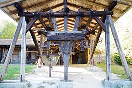
The quartz gravel plant Viechtach has been in operation since 1892. In 1928, a cableway and railroad was built to transport the material to the quetsche ( crusher ), which transported the broken rock in fifteen hanging lorries into the valley until 1967. At the mountain station, the carts detached themselves from the transport rope and were driven on a rail to the loading flaps, from which the stones slipped into the carts. Then the cart was hooked back into the pulling rope and drove down to the valley. There the trolleys could be tipped to the side in order to unload them into the crusher. Three men were required to operate the loading station, so that up to 300 lorries could be loaded every day at 2-minute intervals.

Quartz mining at the post near Viechtach

Mining site (quarry)

Transport by rail to the loading station

Loading chute

Loading station with lorry
Railroad at the loading station

Descent by cable car to the Quetsche


Geotopes
Some sections of the entire pile have been designated as geotopes .
National geotope
In 2006 it was included in the list of 77 awarded national geotopes in Germany.
Large stake near Viechtach
The towering rock wall near Viechtach has been designated by the Bavarian State Office for the Environment (LfU) as a geoscientifically valuable geotope (geotope number: 276R002). The rock wall made of pile quartz is one of the most distinctive shapes on the entire pile. To the west of this is a former quarry where pile quartz was extracted. A nature trail describes the special features of the region. The geotope was awarded the seal of approval "Bavaria's 100 most beautiful geotopes" and is explained on site with an information board. Further information at www.lfu.bayern.de/geologie/geotope_schoensten.
In 2002 the LfU awarded the Great Stake near Viechtach the official seal of approval for Bavaria's most beautiful geotopes .
Hiking trails
There are numerous hiking trails around the post, which differ greatly in terms of time required. The most famous hiking trails are around the town of Viechtach . The spectrum ranges from a small round of less than a quarter of an hour to a large round trip, the time required to be calculated at around 2.5 hours.
Web links
- Natural areas of main unit group 40 in the Bavaria Atlas of the Bavarian State Government - Upper Palatinate-Bavarian Forest ( notes ) The stake natural areas and lines are marked in yellow.
- The stake , Bavarian Forest Nature Park
- Information about hiking
Individual evidence
- ↑ https://www.lfu.bayern.de/geologie/bayerns_schoenste_geotope/1/index.htm
- ↑ Shang, CK, Siebel, W., Rohrmüller, H. (2008) The Bavarian Forest basement: geochemistry and Sr-Nd isotope signature and implications for Bavarian granite sources. Journal of Alpine Geology 48 p.99
- ↑ http://petrology.oxfordjournals.org/content/50/4/591.full.pdf
- ↑ http://homepages.uni-tuebingen.de/wolfgang.siebel/pdffiles/siebel_JPET_reply_2009.pdf
- ↑ a b c GeoViewer of the Federal Institute for Geosciences and Natural Resources ( notes )
- ↑ Klaus Müller-Hohenstein: Geographical land survey: The natural space units on sheet 165/166 Cham. Federal Institute for Regional Studies, Bad Godesberg 1973. → Online map (PDF; 4.4 MB)
- ^ Willi Czajka , Hans-Jürgen Klink: Geographical land survey: The natural space units on sheet 174 Straubing. Federal Institute for Regional Studies, Bad Godesberg 1967. → Online map (PDF; 4.3 MB)
- ↑ The 758 m are shown in the book part of sheet 174 Straubing .
- ↑ a b Natural areas of the main unit group 40 in the Bavaria Atlas of the Bavarian State Government - Upper Palatinate-Bavarian Forest ( notes ) The natural areas and lines of the stake are marked in yellow.
- ↑ Stefan Glaser: A long cut in the earth's crust of Bavaria - The "Bavarian Stake" . In: Ernst-Rüdiger Look, Ludger Feldmann (Ed.): Fascination Geology. The important geotopes of Germany , E. Schweizerbart'sche Verlagsbuchhandlung, Stuttgart 2006, ISBN 3-510-65219-3 , p. 64f.
- ^ Bavarian State Office for the Environment, Geotope Großer Pfahl bei Viechtach (accessed on October 23, 2017).
- ↑ Bavarian State Office for the Environment: A picture of a disturbance! Big stake . In: Hundred Masterpieces - The Most Beautiful Geotopes of Bavaria , Augsburg 2012, ISBN 978-3-936385-89-2 , p. 72f.
- ↑ Bavaria's most beautiful geotopes, Großer Pfahl bei Viechtach (accessed on October 23, 2017)
literature
- Bavarian State Office for the Environment: A picture of a disturbance! Big stake . In: Hundred Masterpieces - The Most Beautiful Geotopes of Bavaria , Augsburg 2012, ISBN 978-3-936385-89-2 , p. 72f.
Coordinates: 49 ° 5 ′ 2 " N , 12 ° 51 ′ 36" E