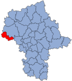
Powiat Gostyniński
| Powiat Gostyniński | |
|---|---|

|

|
| Basic data | |
| State : | Poland |
| Voivodeship : | Mazovia |
| County town : | Gostynin |
| Area : | 615.56 km 2 |
| Residents : | 46,674 (June 30, 2010) |
| License plate : |
WGS
|
| Circle structure | |
| Municipalities : | 1 |
| Urban and rural communities : | 1 |
| Rural communities : | 3 |
| Starostei (Stand:) | |
| Starost : | Jan Baranowski |
| Address: | ul. Dmowskiego 13 09-500 Gostynin |
| Website : | gostynin.powiat.pl/ |
The powiat Gostyniński is a powiat (district) in the Polish Masovian Voivodeship . The district has an area of 615.56 square kilometers, on which about 47,200 inhabitants live.
history
The area of the Powiat Gostynin was incorporated into the Reichsgau Posen , administrative district Hohensalza in 1939 after the German invasion of Poland . From 1941 this district was called Kreis Gasten and from 1943 until the arrival of the Red Army in the spring of 1945 it was called Waldrode district in Reichsgau Wartheland .
Communities
The Powiat includes five municipalities, a municipality , a town-and-country community and three rural communities .
Borough
Urban-and-rural parish
Rural community
Footnotes
- ↑ Główny Urząd Statystyczny, "LUDNOŚĆ - STAN I STRUKTURA W PRZEKROJU TERYTORIALNYM" ( Memento of May 15, 2011 in the Internet Archive ) as of June 30, 2010.
- ↑ See order on the change of place names in the Reichsgau Wartheland, No. 62 of May 18, 1943.
