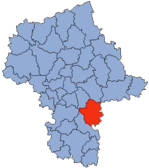
Powiat Garwoliński
| Powiat Garwoliński | |
|---|---|

|

|
| Basic data | |
| State : | Poland |
| Voivodeship : | Mazovia |
| County town : | Garwolin |
| Area : | 1284.29 km 2 |
| Residents : | 107,016 (June 30, 2010) |
| Degree of urbanization : | 27.31% |
| License plate : |
WG
|
| Circle structure | |
| Municipalities : | 2 |
| Urban and rural communities : | 2 |
| Rural communities : | 10 |
| Starostei (Stand:) | |
| Starost : | Stefan Gora |
| Address: | ul.Staszica 15 08-400 Garwolin |
| Website : | www.garwolin-starostwo.pl |
The powiat Garwoliński is a powiat (district) in the Polish Masovian Voivodeship . The powiat has an area of 1284.29 km² on which about 106,000 inhabitants live.
cities and communes
The powiat comprises fourteen municipalities, including two urban parishes, two urban and rural parishes and ten rural parishes .
Borough
Urban and rural municipality
Rural community
- Borowie
- Garwolin (rural community)
- Górzno
- Łaskarzew (rural municipality)
- Maciejowice
- Miastków Kościelny
- Parysów
- Sobolev
- Trojanów
- Wilga
Cities
Footnotes
- ↑ Główny Urząd Statystyczny, "LUDNOŚĆ - STAN I STRUKTURA W PRZEKROJU TERYTORIALNYM" ( Memento from May 15, 2011 in the Internet Archive ) as of June 30, 2010
