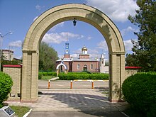
Privolnoye (Stavropol, Krasnogwardeiski)
| Village
Privolnoe
Привольное
|
||||||||||||||||||||||||||||||||
|
||||||||||||||||||||||||||||||||
|
||||||||||||||||||||||||||||||||
Priw o lnoje ( Russian Привольное ) is a village (Selo) with 3350 inhabitants (as of October 14, 2010) in the Stavropol region in Russia .
geography
The place lies in the steppe landscape of the northern Caucasus foreland on both sides of the river Jegorlyk , a little below the confluence of its left tributary Kalaly . Privolnoye is a good 100 km as the crow flies in a north-westerly direction from the regional administrative center of Stavropol . Immediately to the north runs the border with the neighboring Rostov Oblast , about 10 km west the border with the Krasnodar region .
Privolnoye belongs to the Krasnogwardeiski Raion , whose center Krasnogwardeiskoje is located almost 20 km east-southeast, also on the left bank of the Yegorlyk. Privolnoje forms the rural community (selskoje posselenije) Privolnenski selsowet, to which, in addition to the village, the hamlet (chutor) Bogomolow with 158 inhabitants, 6 km southeast on the left bank of the Yegorlyk, belongs.
history
The village goes back to the hamlet of Sorokin (also Sarokin or Surotschin ) that was built on the right bank of the Jegorlyk in the 1830s , possibly a relocation of the village of Kalalowka (originally also Westoslawskoje or Kalaly ), which was founded at the end of the 18th century and no longer exists today. . In 1848 the place became an independent village under its current name - partly also in the form of Privolje - (from a Russian word for free , but also extensive , presumably in relation to the lands found there by the settlers), in 1853 a church was built. Due to its location on the “Great Cherkassk Trakt”, part of the postal connection between Moscow and Stavropol, the village , which was predominantly inhabited by “Little Russians” ( Ukrainians ) in the 19th century, developed well economically. In 1894 it had 4,441 inhabitants, two schools, a pharmacy, 22 commercial establishments and 13 mills and “small factories”.
Originally located only on the right bank of the Jegorlyk, the village also expanded on the other bank, where the central part is today. Administratively it initially belonged to the Ujesd Stavropol of the governorate of the same name , from 1872 to its newly created Ujesd Medweschje (original name of today's Krasnogwardeiskoje). As part of the Soviet administrative reform, Privolnoye came to Medweschje Rajon in 1924, which was called Evdokimowski from 1935 and Molotovsky from 1939, until it was finally given its current name Krasnogwardeiski (from Krasnaya Gwardija , Red Guard ) in 1957 .
During World War II , Privolnoye was occupied by the German Wehrmacht from August 1942 to January 1943 .
Population development
| year | Residents |
|---|---|
| 1894 | 4441 |
| 1989 | 3285 |
| 2002 | 3491 |
| 2010 | 3350 |
Note: from 2002 census data
In the first half of the 20th century, the population fell below the 3000 mark, which was only exceeded again in the 1980s.
Culture and sights
There are two cultural centers in the village . A new church of Our Lady of Kazan was built between 2000 and 2006, replacing the original village church of the same name, which no longer existed from 1853.
Economy and Infrastructure
In Privolnoye there are plants for the production and processing of agricultural products, as well as a pumping station on a natural gas pipeline . The regional road R269, which connects Bataisk not far from Rostov-on-Don with Stavropol, runs through the village .
From 1990, the place also had a train station (station name Priwolnaja , according to other information Priwolnoje-na-Jegorlyke ) on the railway line from Peschanokopskaya (between Salsk and Belaya Glina ) to Peredowaya (near Isobilny ) , which was built in the late 1980s . The main reason for the construction of the line is said to have been that the then Soviet head of state Mikhail Gorbachev came from Privolnoye; the initiative to build it is said to have come from himself. Therefore, the route was popularly called Gorbachevka or, ironically, Gorbachev's BAM . As early as the end of the 1990s, the section between Peschanokopskaya and Krasnogwardeiskoje ( Krasnaya Gwardija station ) , which was in deficit due to the decline of the Russian economy and leading past Privolnoye, was shut down again and soon afterwards dismantled.
Sons of the place
- Mikhail Gorbachev (* 1931), Soviet politician
Web links
- Official website of the rural community (Russian)
Individual evidence
- ↑ a b c Itogi Vserossijskoj perepisi naselenija 2010 goda. Tom 1. Čislennostʹ i razmeščenie naselenija (Results of the All-Russian Census 2010. Volume 1. Number and distribution of the population). Tables 5 , pp. 12-209; 11 , pp. 312–979 (download from the website of the Federal Service for State Statistics of the Russian Federation)
- ↑ Privolye . In: Энциклопедический словарь Брокгауза и Ефрона - Enziklopeditscheski slowar Brokgausa i Jefrona . tape 25 [49]: Праяга – Просрочка отпуска. Brockhaus-Efron, Saint Petersburg 1898, p. 147 (Russian, full text [ Wikisource ] PDF ).
- ↑ Nikolai Grishchenko: Tochka na map - doroga w nikuda . Article on vokrugsveta.com (Russian).


