Puez tips
| Puez tips | ||
|---|---|---|
|
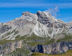
The Puezspitzen from the south at Lech de Crespeina of view |
||
| height | 2918 m slm at the western Puezspitze | |
| location | South Tyrol , Italy | |
| Mountains | Puez group | |
| Dominance | 2.7 km → Wasserkofel | |
| Notch height | 301 m ↓ Roascharte | |
| Coordinates | 46 ° 35 '53 " N , 11 ° 48' 50" E | |
|
|
||
The Puez peaks ( Pizes de Puez in Ladin ) are a two-peaked mountain in the South Tyrolean Dolomites . The western summit, the western Puezspitze , is the highest point of the Puez group at 2918 m , while the eastern summit, the eastern Puezspitze , is a little lower at about 300 m away at 2913 m .
Location and surroundings
The Puez peaks are located in the northwest of the Puez group in the South Tyrolean Dolomites ( Italy ). The west summit ( 2918 m ) and the east summit ( 2913 m ) are separated by a small notch and about 300 m apart. The ridge continues to the west to Piz Duleda ( 2909 m ). To the southeast the ridge sinks to the significantly lower Puezkofel ( 2725 m ). Towards the south the mountain structure drops over the Puezalm into the Vallunga , while towards the north a ridge branches off at the Puezspitzen, which separates the upper Campiller valley from the Zwischenkofeltal and reaches its highest point with the Piz Somplunt ( 2738 m ).
The municipal boundary of St. Martin in Thurn and Selva di Val Gardena runs over the summit ridge . The entire mountain range is part of the Puez-Geisler Nature Park .
Alpinism
The eastern Puezspitze is an important tourist destination that can be reached via a marked trail. This begins at the Puezhütte located to the southeast , crosses the southern slopes of the Puezkofel and then leads with many serpentines through steep terrain from the southeast to the summit. The ascent is described in the literature as not difficult and is often combined with the ascent of the Puezkofel.
Surname
The Puez peaks probably owe their name to the Puezalm to the south, even if the peaks themselves were previously documented by name. A Paiz kofl was mentioned in 1520 , while a Puetsen B. appears in the Atlas Tyrolensis from the second half of the 18th century . The etymology of the word Puez is unclear. Possibly related to a pre-Roman bova meaning debris flow caused by landslide .
Since the Piz Duleda is occasionally counted among the Puez peaks, it also appears as the western Puez peak , which turns the otherwise so-called 2918 m high peak into the middle Puez peak .
Web links
Individual evidence
- ↑ a b Hanspaul Menara and Hannsjörg Hager: Mountains and mountaineers. Alpine history of South Tyrol . Athesia, Bozen 1994, ISBN 88-7014-809-2 , p. 219
- ↑ The information comes from the following map: Kompass , Gadertal - Val Badia, sheet 51, 1: 25000
- ↑ Hanspaul Menara : 1000–1500 meters in altitude . Athesia, Bozen 2012, ISBN 978-88-8266-822-8 , p. 159-161 .
- ^ Egon Kühebacher : The place names of South Tyrol and their history. The historically grown names of the mountain ranges, summit groups and individual peaks of South Tyrol. Athesia, Bozen 2000, ISBN 88-8266-018-4 , p. 225.

