
Qarunsee
| Qarun lake | ||
|---|---|---|

|
||
| Fishing boats on Lake Qarun | ||
| Geographical location | Egypt | |
| Tributaries | Bahr Yusuf , Bahr Qarun | |
| Drain | drainless (evaporation) | |
| Islands | Jazīrat al-Qarn adh-Dhahabī (3 km²) | |
| Places on the shore | 'Azbat Shakshuk | |
| Data | ||
| Coordinates | 29 ° 28 ' N , 30 ° 37' E | |
|
||
| Altitude above sea level | 45 m below sea level | |
| surface | 233 km² | |
| length | 40 km | |
| width | 5.7 km | |
| volume | 0.978.6 km³ | |
| Maximum depth | 12 m | |
| Middle deep | 4.2 m | |
| Catchment area | 1270 to 1700 km² | |

The Qarun Lake ( Arabic بحيرة قارون, DMG Buḥairat Qārūn , also Birket Qarun /بركة قارون / Birkat Qārūn and Birket Kerun ) is a 230 km² lake in northeastern Egypt . It is considered to be the remnant of Lake Moeris .
The outflow-free lake, which is 40 km long, 5.7 km wide and an average of 4.2 m deep, is located west of the Nile in the northwest of the Fayyum basin , into which the Bahr Yusuf ("Joseph's Canal" branching off from the Nile ) ) and feeds the lake. Within the framework of this basin , the lake is in a depression , with its banks about 45 m below sea level . The depth of the lake ranges from 5 meters in the east to 12 meters in the west.
The lake is becoming too salty due to the constant supply of minerals , high levels of evaporation and the resulting reduction in its size. Its salt content fluctuated between 2.4 and 45.0% in 2003, an average of 11.8% was calculated. The original further pollution by sewage of the 2.5 million inhabitants of the valley has recently been alleviated by the construction of a large sewage treatment plant.
The quarry road on the Qarunsee , which is considered to be the oldest preserved paved road in the world, is located by the lake .
Moeris
| Qarunsee in hieroglyphics | |||||
|---|---|---|---|---|---|
| Middle realm |
mer-who mr-wr Great Canal |
||||
| Greek | Moeris | ||||
Moeris ( Moeris lake , ancient Egyptian mer who ) was with the ancient Greeks , the name of a large, by dams limited artificial lake in Lower Egypt , which as a reservoir for the excess flood water of the Nile should have served. Today the Qarun lake is identified with the Moeris. The ancient Egyptian mer-who is translated as "large canal".
Herodotus attributes the origin of the lake to the legendary King Moeris, who, however, cannot be proven historically. In the 12th dynasty (19th century BC) Amenemhet III. Build locks to protect the cultivated land reclaimed from the swampy Fayyum from the flood of the Nile.
The location of the lake was unclear for a long time. While the Qarun lake ( Birket el-Kerun ) on the western edge of the Fayyum had already been mistaken for the Moeris lake, Linant de Bellefonds ( Mémoire sur le lac Moeris , 1842) referred it to the southeast corner. On the other hand, F. Cope Whitehouse , based on Herodotus' given circumference of the lake of 3,600 stages - which Linant believed he had to limit to 360 - gave the Moeris Lake a larger circumference and assumed an extension to the south-west. Flinders Petrie then took up the old and probably correct view that the lake was located in the western delta and the Qarun lake was a last residue.
Herodotus reported in detail about the Moeris Lake in his writings:
“ II.101 Of the other kings ... they only told of one, the very last one with the name Moeris. He had ... dug a lake ... and built pyramids in it. II.149 So the so-called Mörissee arouses even greater admiration ... Its circumference is 3,600 stadia (about 634 km) ... The length goes from midnight to noon , its greatest depth is 50 fathoms (200 cubits, about 105 m), because a fathom measures six feet or four cubits ... Approximately in the middle of the lake there are two pyramids and each has 50 fathoms (above the water) ... So each pyramid has 100 fathoms (about 210 m). ..But the water in the lake ... came in from the Nile through a ditch. Six months it flows into and six months back in the Nile back. II.150 But people told me that this lake pours ... underground in Libya and turns into the middle of the country in the evening , next to the mountains above Memphis . And because I didn't see the debris ejection anywhere ... they (the people) told me ... that they threw the debris into the Nile ... So they said that this lake was dug. "
Strabo mentioned that 100 stadiums (about 18 km) from the canal is the city of Arsinoe , where the “ labyrinth ” is also said to have been. It is the mortuary temple in the Fayyum basin near the Hawara pyramid of Amenemhet III. in the town of Hawara , southeast of Arsinoe , which is referred to in hieroglyphic writing as lprnt, which is now interpreted as lo-pe-ro-hunt ("palace on the lake").
supporting documents
The connection established in this context to the King "Moeris" named by Herodotus cannot be proven historically. Rather, the kings of the 12th Dynasty partially drained the lake to use it as a water reservoir . The agricultural infrastructure could also be improved through the expansion of the irrigation canals .
Amenemhet III. had two locks built at the exit of the Fayyum during his reign in order to enlarge the lake as an additional reservoir for the Nile water that accumulates during the Nile flood . The locks he used must have been eye-catching structures, as their functional architecture was still admired by Greek travelers at a later time .
photos

Map sheet with Fayyum basin and Qarun lake
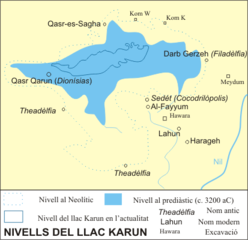
historical water level (3200 BC)


literature
- Rainer Hannig : Large Concise Dictionary Egyptian-German: (2800 - 950 BC) . von Zabern, Mainz 2006, ISBN 3-8053-1771-9 , p. 1150.
- Wolfgang Helck , Eberhard Otto : Small Lexicon of Egyptology . Harrassowitz, Wiesbaden 1999, ISBN 3-447-04027-0 , p. 190.
Individual evidence
- ^ Bird Life International: Lake Qarun Protected Area
- ↑ Tour Egypt: Birket (Lake) Qarun
- ↑ Lake Moeris Quarry Road - ASCE. In: asce.org. Retrieved September 7, 2017 .