Retention basin Auhof
| Retention basin Auhof flood retention system in Auhof, flood collection basin in Weidlingau, retention systems in Hadersdorf-Weidlingau |
|||||||
|---|---|---|---|---|---|---|---|
| Tower adorned final structure | |||||||
|
|||||||
|
|
|||||||
| Coordinates | 48 ° 12 '20 " N , 16 ° 13' 56" E | ||||||
| Data on the structure | |||||||
| Construction time: | 1895-1899 | ||||||
| Height of the barrier structure : | 8 m | ||||||
| Crown width: | 2 m | ||||||
| Data on the reservoir | |||||||
| Storage space | 1,160,000 m³ | ||||||
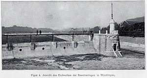
| View of the end of the basin system in Weidlingau | |||||||
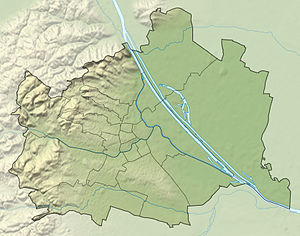
The Auhof retention basins (or flood retention system in Auhof , flood collection basins in Weidlingau , retention systems in Hadersdorf-Weidlingau ) in Auhof on the border between the 13th ( Hietzing ) and 14th district of Penzing in Vienna were built as part of the Vienna river regulation . Their task is to intercept the rapidly increasing and decreasing flood waves typical of Vienna .
Vienna river regulation
As early as the 1880s, the Vienna City Planning Office was dealing with draft regulations for the Vienna River. The project that was finally implemented unites the Vienna and the Vienna Stadtbahn in a uniform profile that offered some technical and also an economic advantage.
The project, which stretched over a distance of around 17 kilometers, was divided into three large groups:
- The construction of the future course of the river
- The bottom and the bank walls were built in the correct position and constructed in such a way that they could easily be used as an abutment for a further vault if required later. For example, the vaulting at the Naschmarkt did not take place until 1913–1915.
- The establishment of collecting canals on both sides of the Vienna
- The construction of flood collecting basins in Weidlingau at the beginning of the regulatory section
Work on the first construction lot for the flood retention basin began on April 1, 1895, and construction on the second construction lot began two years later. The construction work was completed on November 19, 1899. The computer systems were installed by the end of the following year .
Since June 15, 2001, both the retention basin ( list entry ) and the official building of the Vienna River Authority ( list entry ) have been under monument protection .
Flood reservoir
Location
The flood collection basins, also known as sewers, were built near Weidlingau at the west end of the Vienna river route to be regulated in the area of the confluence of the Mauerbach between the Lainzer Tiergarten and the western railway route on an area of around 37 hectares.
Those involved in construction
The Vienna City Building Office was responsible for the planning and site management, with Franz Berger as its director and Franz Kindermann as the site manager. The master builder work was carried out by " Doderer, Göhl & Sager ", the computer systems come from R. Ph. Waagner .
Task and dimensioning
The Vienna River normally carries around 200 liters of water per second, but in extreme cases this value can rise to over 450,000 liters in a short time.
The location at the confluence of the Mauerbach into the Wien River was chosen because long-term observations had shown that the flood waves threatening Vienna always arose when both bodies of water were flooding at the same time.
The basins were dimensioned so that a maximum of 480 cubic meters of water per second in the Vienna and a maximum of 130 cubic meters of water per second in the Mauerbach (= 610 cubic meters of water per second) a maximum of 400 cubic meters of water per second through the newly designed channel towards the Danube Canal. The remaining 210 cubic meters of water per second were to be retained in the retention basin until the flood wave subsided again and the course of the Vienna could again absorb additional water.
Since it had also been determined that such a flood wave hardly lasted longer than two hours, the capacity of the basins was designed so that their volume can accommodate the 210 cubic meters per second that the hard-built Vienna River in this period of time can accommodate for these two hours Vienna cannot accommodate. This resulted in a volume of 1,600,000 cubic meters.
Currently, 1,160,000 cubic meters are mentioned for the six retention basins on the Vienna and 150,000 cubic meters for the one on the Mauerbach.
System and functionality
The facility consists of six successive retention basins separated by concrete walls (section II to section VII) on the south side of the area.
The distribution structure (barrage) is located on the north side of the weir (“concrete traverse”) between sections II and III. This is where the circulating ditch begins, which runs around 1,300 meters long on the north side of sections III to VII. On its north side, this ditch was bordered by the former Poststrasse to Linz and the track structure of the Western Railway. In the south, the channel is separated from the reaches by a 6 to 8 meter high and at the crown about 2 meters thick concrete wall. The eastern end of this wall at the so-called end works was architecturally designed somewhat more elaborately, received a pylon-like top and is clad with stones. This channel was traversed by the waters of the Wien River and the Mauerbach.
The main task of section II (pre-basin) was to function as a sedimentation basin. The widening of the river bed that takes place here should allow debris and suspended matter to be deposited. Floating debris washed up by the tidal wave was to be stopped by computer systems around the distribution works and on the adjacent concrete traverse.
Pipes were built into the defensive walls between the sections as passages. These should allow water to drain into the next basin before the weir crown was flooded. The outflows of the last weir into the Wien River are equipped with non-return valves, which should prevent the ingress of water from the bypass ditch.
In order to be able to empty the individual retention basins again after a flood, sluices were built into the wall that separates the bypass ditch and sections III to VII.
By operating the distribution system, the retention basins were flooded when the Vienna channel in the city area reached its capacity limit. The barrage was modernized in 1956. 24 men were required to operate the winches of the original rifle system.
Another retention basin (section I ⊙ ) with a front basin as a sedimentation basin was built for the Mauerbach on its left bank in front of the confluence with the Vienna. This is also only flooded when the creek's capacity limits are reached.
modernization
Above all, the expansion of the Vienna underground lines in recent decades made it necessary to expand flood protection along the Vienna River (water that penetrates from the Vienna River into the route of the neighboring U4 could, in the worst case of a disaster, either go to a lower-lying station at Längenfeldgasse Penetrate the tunnel of the U6 , in the worst case flood the entire station building at Karlsplatz from the lowest located U1 or flood the U3 at the Landstrasse station .). It was therefore decided to increase flood protection in the inner-city area to a 1000-year flood (418 cubic meters of water per second). On this occasion, the retention basins should also be designed as new habitats.
In order to optimize the retention effect of the retention basins, movable weir locks were built into the defensive walls. This also gave the Wien river the opportunity to flow through the channels when the water level was low or medium and to create its own riverbed there.
In the event of an emergency, the weir closure in weir 1 is closed between sections II and III and the Wien river is diverted via the diversion channel. On the other hand, the weir lock in weir 6 is partially opened to allow the water of the two streams that flow from the Lainzer Tiergarten into the retention basin to drain away.
The filling of the retention basin begins after a hundred-year flood (360 cubic meters of water per second).
The responsible municipal department (MA) 45 - Vienna Waters is supported by a forecast model created by the University of Karlsruhe , which can be adapted for the respective catchment areas. The central computer receives information from specially built measuring stations, which transmit their data at intervals of one to 15 minutes.
Unfortunately, no precise information is available about the period of modernization.
Efforts to improve flood protection in the west of Vienna received additional support through the closure of the Wiental waterworks in 2004. The artificial Wienerwaldsee was transferred to the administration of Municipal Department 45 and was redesigned to meet the needs of flood protection.
Municipal Vienna river supervision
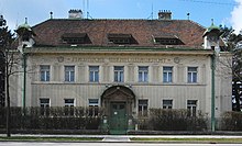
The monitoring and flood service was carried out by six officers and five guards. Two officers and a supervisor lived in a specially built service building for the Vienna River Authority, with the distribution plant at the rear. Separate telephone and telegraph lines have been set up for the rapid transmission of messages to the town hall , the Am Hof fire brigade headquarters and along the Wien River from its confluence with the Danube Canal to Tullnerbach .
Today this is a task of the Municipal Department (MA) 45 - Vienna Waters.
Biotope
The retention basin in Auhof represent the largest wetland in the western city of Vienna is. Fauna and flora in the basins are largely left to their own is, by repeatedly taking place floods prevail here similar conditions as in floodplains .
Beavers , muskrats and otters , among others , have settled here , but around 120 species of birds ( kingfishers , black storks , reed warblers and thrush warbler ) have also found a habitat here.
Engineering biological test track
In cooperation with the University of Natural Resources and Life Sciences Vienna (Institute for Engineering Biology and Landscaping) and the Municipal Department (MA) 45 - Vienna Waters, the worldwide unique engineering biological test section with a length of 170 meters was built in March 1996 after the barrage. Artificially generated floods with flow rates of 30 - 50 cubic meters of water per second can be used here to test biological engineering bank structures for their resilience. Numerous publications are a result of the knowledge gained here.
literature
- Journal of the Austrian Association of Engineers and Architects , Issue 49, Vienna, December 6, 1895
- The water supply as well as the systems of the municipal electricity works, the Vienna river regulation, the main collecting canals, the light rail and the regulation of the Danube canal in Vienna , edited by the municipal construction department on behalf of the mayor Karl Lueger, self-published by the Viennese municipal council, Vienna, 1901
- Vienna at the beginning of the XX. Century - A guide in the technical and artistic direction , published by the Austrian Association of Architects, Verlag von Gerlach & Wiedling, Vienna, 1903
- Technical guide through Vienna , published by the Austrian Association of Engineers and Architects, edited by Ing. Martin Paul (urban planning inspector), Vienna, published by Gerlach & Wiedling, 1910
- Hietzing - A home book of the 13th district of Vienna, published by the Arbeitsgemeinschaft für Heimatkunde in Hietzing, Austrian Federal Publishing House for Education, Science and Art, Vienna, 1925
- Manfred Wehdorn, Ute Georgeacopol-Winischhofer: Architectural monuments of technology and industry in Austria - Vienna, Lower Austria, Burgenland - Volume 1, Hermann Böhlaus Nachf. Gesellschaft mb H. Graz Vienna, 1984, ISBN 3-205-07202-2
- Annual report of the Federal Hydraulic Engineering Administration 2005 , published by the Federal Ministry of Agriculture, Forestry, Environment and Water Management, Vienna, 2006
- Annual report of the Federal Hydraulic Engineering Administration 2006 , published by the Federal Ministry of Agriculture, Forestry, Environment and Water Management, Vienna, 2007
Individual evidence
- ^ Vienna at the beginning of the XX. Century
- ^ A b Manfred Wehdorn, Ute Georgeacopol-Winischhofer: Architectural monuments of technology and industry in Austria
- ↑ http://www.architektenlexikon.at/de/40.htm
- ↑ http://www.architektenlexikon.at/de/296.htm
- ↑ The water supply and the facilities of ...
- ↑ a b Vienna river flood protection. Municipality of Vienna, accessed on December 9, 2017 .
- ↑ Technical guide through Vienna
- ^ Hietzing - A home book of the 13th Viennese district
- ↑ http://www.wien.gv.at/rk/historisch/1956/mai.html
- ↑ Annual report of the Federal Hydraulic Engineering Administration 2006
- ↑ Redesigned flood protection in the west of Vienna. City hall correspondence, August 4, 1998, accessed December 9, 2017 .
- ↑ a b Engineering biological test section ( Memento from April 26, 2005 in the Internet Archive )
- ↑ https://forschung.boku.ac.at/fis/suchen.projekt_uebersicht?sprache_in=de&menue_id_in=300&id_in=2543
Web links
- Vienna river flood protection. Municipality of Vienna, accessed on December 9, 2017 .
- Redesigned flood protection in the west of Vienna
- Engineering biological test section ( Memento from April 26, 2005 in the Internet Archive )


