Raichberg
| Raichberg | ||
|---|---|---|
|
Raichberg (left), Boll and Hohenzollern Castle from Sickingen |
||
| height | 956.5 m above sea level NHN | |
| location | Baden-Württemberg | |
| Mountains | Swabian Alb | |
| Coordinates | 48 ° 18 ′ 20 " N , 8 ° 59 ′ 35" E | |
|
|
||
| rock | White Jura | |
| particularities | Raichbergturm ( AT ), Raichberg transmitter | |
The Raichberg ( 956.5 m above sea level. NHN ) is a distinctive collection and a part of the Albtrauf the southwestern Swabian Alb in the district of Albstadt district Onstmettingen in Zollernalbkreis .
Surroundings

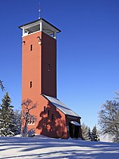
On the summit of the Raichberg are the Raichberg tower and the “Nägelehaus” hiking home, both of which belong to the Swabian Alb Association . There is also a transmission mast . The observation tower offers an excellent panoramic view, with appropriate weather as far as the Black Forest and the Alps .
A saddle almost three hundred meters lower connects the Raichberg with the Hohenzollern Castle in front of it . The Zeller Horn at the top and the oven rock on the northern edge of the high plateau provide a view of the castle.
The Neckar and its tributaries continue to erode the relatively soft Middle Jurassic layers of the Alb eaves until the erosion-resistant Upper Jurassic top layer breaks down, causing the northern edge of the Swabian Alb to recede ever further. From this retrogressive erosion reflects particularly impressive the Hangendenstein , an upcoming rock wall that forms (yet), the eastern edge of the Raichberg Plateau. However, it is already separated from the Raichberg massif by an approximately two-meter-wide and approximately 200-meter-long gap and one day it will completely break off and fall into the valley. In 1879 there was already a landslide of around 315,000 square meters on the Hanging Stone. The upstream eaves slope is littered in places with large blocks up to several meters thick. The hanging stone lies on the north-east edge fault ( Raichberg fault ) of the Hohenzollern ditch . Due to its location inside the trench, its rock consists of mass limestone from the White Jurassic δ ( Kimmeridgian ).
Immediately below the summit is a show charcoal pile from the Swabian Alb Association. This is exactly where charcoal was burned until the middle of the 19th century . An information board provides information about the history of charcoal burning and the mining of Bohner ore on the Zollernalb.
The “Fuchsfarm” youth center is only a few hundred meters away from the coal pile, a former silver fox farm that was acquired by the Swabian Alb Association in 1964 and expanded into a youth hostel.
Transmitter
On the Raichberg there has been a basic network transmitter of the Südwestrundfunk (formerly the Südwestfunk ) for radio and television since 1950 , the Raichberg transmitter with a highly visible tubular steel mast built in 1971 that is now 137 meters high.


