Rega (river)
| Rega | ||
|
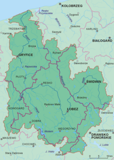
Rega catchment area |
||
| Data | ||
| location | northwestern Poland | |
| River system | Rega | |
| River basin district | Or | |
| source | controversial | |
| muzzle | as Neue Rega near Mrzeżyno (Deep) in the Baltic Sea Coordinates: 54 ° 8 ′ 46 ″ N , 15 ° 17 ′ 7 ″ E 54 ° 8 ′ 46 ″ N , 15 ° 17 ′ 7 ″ E |
|
| Mouth height |
0 m npm
|
|
| length | 167.8 km | |
| Catchment area | 2,724.9 km² | |
| Left tributaries | Stara Rega ( Fuchsfließ ), Łoźnica ( Lotznitz ), Reska Węgorza , Piaskowa ( Paatziger Bach ), Ukleja ( Ückeley ), Sąpólna ( Zampel ), Gardominka ( Kardeminer Bach ) | |
| Right tributaries | Rekowa ( Krebsbach ), Mołstowa (Molstow) | |
| Reservoirs flowed through | Jezioro Rejowickie ( Lebbin Dam ) | |
| Small towns | Świdwin ( Schivelbein ) , Łobez ( Labes ) , Gryfice ( Greifenberg ) , Trzebiatów ( Treptow ad Rega ) | |
|
Rega - Łobez (Labes) |
||
The Rega is a 168 km long river in the Polish West Pomeranian Voivodeship . It rises in the Pomeranian Lake District and flows into the Baltic Sea .
Rega begins in the Pomeranian Lake District between Świdwin ( Schivelbein ) and Złocieniec ( Falkenburg ). There is no agreement on the exact start of Rega. According to one perspective, it rises from the Resko Górne ( Ritzigsee ) near Nowe Resko ( Ritzig ) at a height of 146 m . According to another perspective, a stream that rises about 4 km further north near the village of Imienko ( Immenberg ) at an altitude of 177.5 m forms the beginning of the Rega. The official German map from 1936 of the Reichsamt für Landesaufnahme shows the name “Rega” for both tributaries, namely the name “Rega (lake graben)” for the inflow from the Ritzigsee and the name “Rega (quarry graben)” for the stream that rises near Immenberg ) ".
Rega's catchment area is 2,725 km² . It flows northwards past the towns of Świdwin ( Schivelbein ), Łobez ( Labes ), Resko ( rain forest ), Płoty ( Plathe ), Gryfice ( Greifenberg ) and Trzebiatów ( Treptow an der Rega ). The river is divided in the estuary area. The Alte Rega flows through the Resko Przymorskie ( Kamper See ) before it flows into the Baltic Sea at Dźwirzyno ( Kolberger Deep ) . The Neue Rega, an artificial arm of the river, flows into the Baltic Sea at Mrzeżyno ( Treptower Deep ).
Rega is dammed several times along its course. Small hydroelectric power plants are located at many dams to generate electricity. The largest tributary of the Rega is the Mołstowa ( Molstow ).
Railway bridge over the Rega near Nowielice ( Neuhof ) near Treptow an der Rega .
Web links
Individual evidence
- ↑ Obszary dorzeczy - Ramowa Dyrektywa Woda ( Memento of August 12, 2014 in the Internet Archive ), accessed on December 29, 2010
- ↑ Johannes Hinz: Pomerania. Signpost through an unforgettable country. Flechsig-Buchvertrieb, Würzburg 2002, ISBN 3-88189-439-X , p. 290.
- ^ Bernard Cedro: Evolution of the River Rega Valley near Łobez in Late Pleistocene and Early Holocene . In: Geochronometria . 2007, p. 56.
- ^ Sheet N-33-80-D , raster map with a compilation of the Polish hydrography . Polish Institute of Meteorology and Water Management, 2007-10.
- ↑ Sheet 2361 Wusterwitz , measuring table sheet 1:25 000, Reichsamt für Landesaufnahme, 1936.


