Rengershausen (Bad Mergentheim)
|
Rengershausen
City of Bad Mergentheim
|
|
|---|---|
| Coordinates: 49 ° 24 ′ 12 ″ N , 9 ° 43 ′ 24 ″ E | |
| Height : | approx. 297 m above sea level NHN |
| Area : | 10.67 km² |
| Residents : | 502 (Jan. 1, 2018) |
| Population density : | 47 inhabitants / km² |
| Incorporation : | February 15, 1972 |
| Postal code : | 97980 |
| Area code : | 07937 |
|
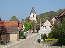
Rengershausen through-town, 2013
|
|
Rengershausen is a district of Bad Mergentheim in the Main-Tauber district in northeast Baden-Württemberg .
geography
The district of the place covers about 10,669 km². A small part of the FFH area Jagsttal Dörzbach-Krautheim protrudes over the district of Rengershausen.
history
The place was first mentioned as Reungershusen .
On February 15, 1972, Rengershausen was incorporated into the city of Bad Mergentheim together with Stuppach . As in the context of on 1 January 1973 Württemberg Baden-district reform the district Mergentheim was dissolved, Rengershausen part in the sequel to the newly formed Tauber district , which its present name on 1 January 1974 Main-Tauber-Kreis received.
Cultural monuments
The parish church of St. Leonhard from 1792 is located in the village .
traffic
Web links
Commons : Rengershausen - Collection of images, videos and audio files
- Rengershausen - Altgemeinde, part of the town on the leo-bw.de website
Individual evidence
- ^ City of Bad Mergentheim: Bad Mergentheimer district Rengershausen . Online at www.bad-mergentheim.de. Retrieved April 2, 2018.
- ↑ a b LEO-BW.de: Rengershausen on the website www.leo-bw.de. Accessed March 31, 2018.
- ^ Federal Statistical Office (ed.): Historical municipality directory for the Federal Republic of Germany. Name, border and key number changes in municipalities, counties and administrative districts from May 27, 1970 to December 31, 1982 . W. Kohlhammer, Stuttgart / Mainz 1983, ISBN 3-17-003263-1 , p. 453 .
- ^ Federal Statistical Office (ed.): Historical municipality directory for the Federal Republic of Germany. Name, border and key number changes in municipalities, counties and administrative districts from May 27, 1970 to December 31, 1982 . W. Kohlhammer, Stuttgart / Mainz 1983, ISBN 3-17-003263-1 , p. 453 f .
- ↑ LEO-BW.de: cath. Parish church, St. Leonhard (Dörzbacher Strasse 52, Bad Mergentheim) . Online at www.leo-bw.de. Retrieved August 20, 2019.

