Spoon stilts
|
Spoon stilts
City of Bad Mergentheim
|
|
|---|---|
| Coordinates: 49 ° 30 '26 " N , 9 ° 47' 22" E | |
| Height : | 347 m |
| Area : | 5.09 km² |
| Residents : | 995 (2014) |
| Population density : | 195 inhabitants / km² |
| Incorporation : | January 1, 1972 |
| Postal code : | 97980 |
| Area code : | 07931 |
|
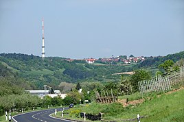
View from the Taubertal up to Löffelstelzen with the transmission tower
|
|
Löffelstelzen is a district of Bad Mergentheim in the Main-Tauber district in northeast Baden-Württemberg .
geography
The water protection area Löffelstelzen with the WSG no. 128124 covers a protected area of 470.66 hectares.
history
middle Ages
Löffelstelzen was first mentioned in a document in 1246 as Löfelsterz. For a long time the place belonged to the Principality of Mergentheim of the Teutonic Order .
Modern times
In 1809 Löffelstelzen came to the Kingdom of Württemberg and there to the Oberamt Mergentheim . Since 1938 Löffelstelzen belonged to the Mergentheim district. On January 1, 1972, the community was incorporated into the city of Bad Mergentheim together with Apfelbach , Althausen , Markelsheim and Neunkirchen . As in the context of on 1 January 1973 Württemberg Baden-district reform the county Mergentheim was dissolved Löffelstelzen part in the sequel to the newly formed Tauber district , which its present name on 1 January 1974 Main-Tauber-Kreis received.
coat of arms
The former coat of arms of the spoonbill shows a black Teutonic Cross in silver, set with a blue wagtail.
Cultural monuments
In the village is the Church of the Most Holy Trinity from 1660/61.
Economy and Infrastructure
Transmitters
To the west of Löffelstelzen, the SWR has been operating a transmitter system since 1951, which serves as a television and radio basic network transmitter (status 2011). About one kilometer north of Löffelstelzen is the radome of a radar system used by the Bundeswehr .
traffic
Web links
Individual evidence
- ↑ spoon stilts. LEO-BW (Landesarchiv Baden-Württemberg), discover regional studies online, accessed on March 16, 2015 .
- ^ Federal Statistical Office (ed.): Historical municipality directory for the Federal Republic of Germany. Name, border and key number changes in municipalities, counties and administrative districts from May 27, 1970 to December 31, 1982 . W. Kohlhammer, Stuttgart / Mainz 1983, ISBN 3-17-003263-1 , p. 453 .
- ^ Federal Statistical Office (ed.): Historical municipality directory for the Federal Republic of Germany. Name, border and key number changes in municipalities, counties and administrative districts from May 27, 1970 to December 31, 1982 . W. Kohlhammer, Stuttgart / Mainz 1983, ISBN 3-17-003263-1 , p. 453 f .
- ↑ LEO-BW.de: cath. Parish church (Alte Würzburger Strasse 12, Bad Mergentheim) . Online at www.leo-bw.de. Retrieved August 20, 2019.

