Republic (Missouri)
| Republic | |
|---|---|
|
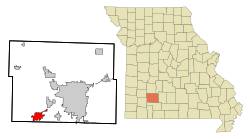
Location in Missouri
|
|
| Basic data | |
| Foundation : | 2005 |
| State : | United States |
| State : | Missouri |
| Counties : |
Greene County Christian County |
| Coordinates : | 37 ° 7 ′ N , 93 ° 29 ′ W |
| Time zone : | Central ( UTC − 6 / −5 ) |
| Residents : | 14,751 (as of 2010) |
| Population density : | 428.2 inhabitants per km 2 |
| Area : | 34.45 km 2 (approx. 13 mi 2 ) |
| Height : | 399 m |
| Postal code : | 65738 |
| Area code : | +1 417 |
| FIPS : | 29-61238 |
| GNIS ID : | 725224 |
| Website : | www.republicmo.com |
| Mayor : | Brian Buckner |
Republic is a city (with the status " City ") in Greene County and a small part in Christian County in the southwest of the US -amerikanischen state of Missouri . In 2010 the city had 14,751 inhabitants.
Republic is part of the metropolitan area around the city of Springfield .
geography
Republic is located in the middle of the Ozarks in the southwestern suburb of Springfield, the center of the region. The city of Republic is located at 37 ° 07'12 "north latitude and 93 ° 28'49" west longitude and extends over 34.45 km².
Neighboring towns are Springfield (13 miles north to the city center), Battlefield (9 miles east), Nixa (16 miles southeast), Clever (10.3 miles south), Billings (9 miles southwest) and Plano ( 15.7 km northwest).
The closest major cities to Springfield are Kansas City (291 km northwest), Missouri's capital Jefferson City (239 km northeast), St. Louis (374 km northeast), Memphis , Tennessee (470 km southeast), Arkansas ' capital Little Rock (356 km south-southeast), Tulsa , Oklahoma (272 km southwest), and Wichita , Kansas (392 km west-northwest).
traffic
Along the northwestern outskirts of Republic, Interstate 44 runs from Oklahoma City via Springfield to St. Louis. In the northeastern borough of Brookline, the Missouri State Route & 360 , which has also been converted into a freeway, branches off , which leads as a southwest tangent around the city of Springfield. US Highway 60 runs northeast-southwest through downtown Republic and meets Missouri State Routes 174 and 413 .
A railway line of the BNSF Railway runs through Republic , which runs from Springfield via Tulsa to Oklahoma City.
The nearest airports are Springfield-Branson National Airport (14 miles northeast) and Branson Airport (57 miles southeast).
Demographic data
According to the 2010 census, the Republic of Republic had 14,751 people in 5,377 households. The population density was 428.2 people per square kilometer. Statistically, 2.53 people lived in each of the 5377 households.
The racial the population was composed of 95.6 percent white, 0.7 percent African American, 0.6 percent Native American, 0.5 percent Asian and other ethnic groups; 2.0 percent were descended from two or more races. Regardless of ethnicity, 2.2 percent of the population was Hispanic or Latino of any race.
29.6 percent of the population were under 18 years old, 59.7 percent were between 18 and 64 and 10.7 percent were 65 years or older. 52.3 percent of the population was female.
The median income for a household was 50,975 USD . The per capita income was $ 21,758. 8.7 percent of the population lived below the poverty line.
Individual evidence
- ↑ a b U.S. Census Bureau, State & County QuickFacts - Republic, MO ( Memento of the original from October 24, 2011 in the Internet Archive ) Info: The archive link was inserted automatically and has not yet been checked. Please check the original and archive link according to the instructions and then remove this notice. Retrieved April 22, 2012
- ↑ Distance according to Google Maps. Accessed on April 22, 2012
