Rhaunelbach
|
Rhaunelbach old name: Raunel |
||
|
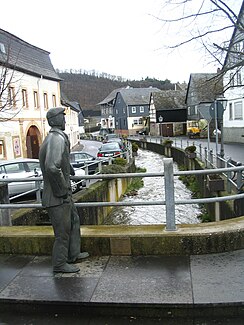
Rhaunelbach with the “Bachspauzer” monument in Rhaunen |
||
| Data | ||
| Water code | DE : 25422 | |
| location |
Hunsrück
|
|
| River system | Rhine | |
| Drain over | Idarbach → Hahnenbach → Nahe → Rhine → North Sea | |
| source | west of Stipshausen in the Idarwald 49 ° 50 ′ 45 ″ N , 7 ° 15 ′ 19 ″ E |
|
| Source height | approx. 650 m above sea level NHN | |
| muzzle | in Rhaunen in the Idarbach Coordinates: 49 ° 51 '58 " N , 7 ° 20' 49" E 49 ° 51 '58 " N , 7 ° 20' 49" E |
|
| Mouth height | approx. 320 m above sea level NHN | |
| Height difference | approx. 330 m | |
| Bottom slope | approx. 38 ‰ | |
| length | 8.7 km | |
| Catchment area | 18.321 km² | |
The Rhaunelbach is a stream in the Hunsrück in the Rhineland-Palatinate district of Birkenfeld , which in Rhaunen flows into the Idarbach from the right after a total of approximately east-northeast .
geography
course
The Rhaunelbach has several source streams in the Idarwald in the west of Stipshausen . The origin of the official source branch is about 2.7 km west of the center of Stipshausen. The here at about 650 m above sea level. The spring branch, which begins on the NHN and is very poor in the catchment area, initially runs south-east steeply down the slope and then reaches the valley floor of the Kappelbach, which runs from west to east and contributes to a much larger sub-catchment area, but has unstable upper reaches.
Passing a quarry on the left slope in the forest, the Rhaunelbach reaches the Hottenbacher Mühlen, where the only small Hottenbach flows in from the right. There the tree line on the left on the slope gives way to this and the stream turns over the municipal boundary from Hottenbach to Stipshausen on now to the end east-northeast to eastern course. He then passes the Stipshausener mills, the Lerchenmühle and the Gerwertsmühle, all of which are on the left side of the course. Then the Kehrbach, which also rises in the Idarwald, flows out after it has last passed through Stipshausen. Further down at the municipal boundary between Stipshausen and Rhaunen , the Wolfsbach is the second left tributary from the west.
Then the Rhaunelbach crosses a small forest area in an open strip of floodplain, after which the left slope at the Bad von Rhaunel opens for a short time, then the right continuously. Already within the local border of Rhaunel it then takes up its longest tributary, the Lingenbach, from the right and from the southwest, which rises deeper than the previous mountain streams in the foothills of the Idarwald. After it has crossed Rhaunen and its town center and crossed the state road L 162 there, the Rhaunenbach finally flows out at about 320 m above sea level. NHN from the right into the Idarbach .
The 8.7 km long Rhaunelbach flows about 330 meters below its origin, its mean bottom slope is thus about 38 ‰.
Catchment area
The most prominent watershed of the 18.3 km² of the Rhaunelbach catchment area is its northwestern one on the ridge of the Idarwald, which is twice heights of about 750 m above sea level. NHN reached, on the western tip and on the northern edge on the 745.7 m above sea level. NHN high Idarkopf . Behind this ridge, the left main line upper course Altbach des Idarbach collects the runoff to the opposite side. The competitors on the other side of the flatter right watershed run from the mouth in a short run to the lower Idarbach, with its upper reaches for a longer period than Wildenbach to the Hahnenbach, which flows together from Idarbach and Kyrbach . The larger competitors, Hosenbach, and its receiving waters, Fischbach , which run further to the east , flow into the Nahe like this before the Hahnenbach .
history
It used to be called the Raunel. Raunel was blamed for many injustices, for example her supposedly polluted water was responsible for the typhus epidemic in Rhaunen at the beginning of the 20th century. Since the stream can change from the sluggish rippling water to a torrential stream when it rains continuously, it now flows in a concrete bed within the locality for flood protection. In some cases, it is completely built over in order to meet the requirements of traffic. Since the people of Rhaun used to like to spit in their Rhaunelbach, they are also called the "Bachspauzer". A figure on the stream railing reminds of this.
According to legend, Raunel also has a daughter, called "Runia". This is a mysterious figure who likes to denounce the grievances in Rhaunen.
Individual evidence
- ↑ a b Map service of the landscape information system of the Rhineland-Palatinate Nature Conservation Administration (LANIS map) ( notes )
- ↑ a b GeoExplorer of the Rhineland-Palatinate Water Management Authority ( information )
