River Esk (Cumbria)
| River Esk | ||
|
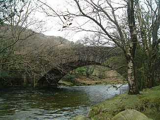
Wha House Bridge, Eskdale |
||
| Data | ||
| location | Cumbria in NW England | |
| River system | River Esk | |
| River basin district | North West | |
| source |
Esk home 54 ° 27 ′ 36 ″ N , 3 ° 11 ′ 6 ″ W. |
|
| Source height | 750 m ASL | |
| muzzle | at Ravenglass in the Irish Sea Coordinates: 54 ° 20 ′ 28 ″ N , 3 ° 25 ′ 31 ″ W 54 ° 20 ′ 28 ″ N , 3 ° 25 ′ 31 ″ W |
|
| Mouth height | 0 m | |
| Height difference | 750 m | |
| Bottom slope | 23 ‰ | |
| length | 32 km | |
| Left tributaries | Stanley Gyhll Beck | |
| Right tributaries | Mite , Irt | |
The River Esk is the name of a river in the Lake District National Park in Northern England .
It is one of the two rivers with that name. It is located in Cumbria and not to be confused with the River Esk , which flows into Dumfries and Galloway near the Scottish border.
The river has its source in the Sca Fell massif at an altitude of approx. 750 meters below the Esk home pass between Great End and Esk Pike . The source river flows through the Great Moss and is fed there by numerous smaller streams, one of the main ones being Little Narrowcove , which rises east below Mickledore between Sca Fell and Scafell Pike . After some steep steps at the end of the Great Moss he is in the course of Lingcove Beck and Hard Knott Beck strengthened in order through the valley Eskdale to flow and at Ravenglass in an estuary , into which the rivers Mite and Irt flowing into the Irish Sea to flow out.
The origin of the name is derived from the Old Welsh word esk for "water", but also from the short form for Esker (or Os ), as there are examples of this geological formation in the course of the river .
Web links
Individual evidence
- ^ Robert Gambles, Lake District Place Names , Dalesman Books, Clapham 1985
