Rogi (Niemodlin)
| Rogi Rogau |
||
|---|---|---|
 Help on coat of arms |
|
|
| Basic data | ||
| State : | Poland | |
| Voivodeship : | Opole | |
| Powiat : | Opolski | |
| Gmina : | Niemodlin | |
| Geographic location : | 50 ° 40 ′ N , 17 ° 31 ′ E | |
| Height : | 170-180 m npm | |
| Residents : | 189 (March 31, 2011) | |
| Postal code : | 49-156 | |
| Telephone code : | (+48) 77 | |
| License plate : | OPO | |
| Economy and Transport | ||
| Next international airport : | Wroclaw | |
Rogi ( German Rogau ) is a village in the Gmina Niemodlin , in the powiat Opolski , the Opole Voivodeship in southwestern Poland .
geography
Geographical location
The street village Rogi is located about 8 kilometers west of the municipal seat Niemodlin (Falkenberg) and about 33 kilometers west of the district town and voivodeship capital Opole . Rogi lies in the Nizina Śląska (Silesian Plain) within the Równina Niemodlińska (Falkenberg Plain) .
Neighboring places
Northwest of Rogi is Tarnica ( Eng . Tarnitze ), in the south Rutki (Rautke) , in the southeast Roszkowice (Roßdorf) and southwest Tłustoręby (Kirchberg) .
history
A church was mentioned as early as 1335. The village was first mentioned in 1412. In 1685 a wooden church was built in the village.
After the First Silesian War in 1742, Rogau and most of Silesia fell to Prussia . In 1790 a school house was built. In 1792 the village consisted of 3 farms, 18 gardeners and 2 cottagers; it had 129 inhabitants.
After the reorganization of the province of Silesia , the rural community of Rogau belonged to the district of Falkenberg OS in the administrative district of Opole from 1817 . In 1845 the village consisted of 48 houses, a castle, a Protestant school and a farm. In the same year, 267 people lived in Rogau, 107 of them Catholic. In 1855 124 people lived in the village. In 1860 the estate and castle were sold to Friedrich Wilhelm von Praschma . In 1865 the village had 3 farms, 19 gardeners and 4 cottagers. The school was attended by 54 students in the same year. In 1874 the Graase district was founded, which consisted of the rural communities Graase, Groß Mangersdorf, Groß Sarne, Klein Mangersdorf, Raschwitz, Rogau and Rautke and the manor districts Graase, Groß Sarne, Klein Mangersdorf, Raschwitz and Rautke. In 1885 Rogau had 211 inhabitants.
Between 1901 and 1903 a new church was built in Rogi. In 1933 there were 311 people in Rogau. In 1939 the village had 340 inhabitants. Until the end of the war in 1945, the place Rogau belonged to the district Falkenberg OS
In February 1945 the village was captured by the Red Army . Then the previously German town of Rogau came under Polish administration, was renamed Rogi and joined the Gmina Niemodlin. In June 1946 the remaining German population was expelled. In 1950 the place came to the Opole Voivodeship . In 1999 the place came to the re-established Powiat Opolski as part of Gmina Niemodlin .
Attractions
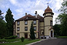
- The Rogau castle built in the first half of the 19th century in the same place. In 1860 the Praschma family bought the property. In 1897 the castle was expanded and rebuilt. After the Praschma family gave up the castle in the 1930s, it was temporarily used as an orphanage, a children's health institution and as a labor camp. After the Second World War, a primary school was set up in the castle and it still exists today. The castle is located in a landscaped park with numerous old trees, mainly English oaks.
- Catholic Church of the Birth of the Virgin Mary - built between 1901 and 1903 in neo-Romanesque style.
societies
- Volunteer Fire Brigade OSP Rogi
Web links
Individual evidence
- ↑ CIS 2011: Ludność w miejscowościach statystycznych według ekonomicznych grup wieku (Polish), March 31, 2011, accessed on January 27, 2019
- ↑ a b c d Parish of Our Lady Assumption in Heaven (Polish)
- ↑ a b c Palace Slaska (Polish)
- ↑ a b Cf. Felix Triest: Topographisches Handbuch von Oberschlesien. Breslau 1865, p. 1132.
- ↑ a b c Heimatverein des Kreises Falkenberg O / S (ed.): Heimatbuch des Kreis Falkenberg in Oberschlesien. Scheinfeld 1971, pp. 226-227.
- ^ Johann Georg Knie: Alphabetical-statistical-topographical overview of the villages, spots, cities and other places of the royal family. Preuss. Province of Silesia. Breslau 1845, p. 551.
- ↑ Territorial District Graase
- ↑ District of Falkenberg OS
- ↑ Michael Rademacher: German administrative history from the unification of the empire in 1871 to the reunification in 1990. Landkreis Falkenberg (Polish Niemodlin). (Online material for the dissertation, Osnabrück 2006).


