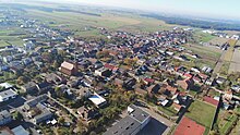
Rostarzewo
| Rostarzewo | ||
|---|---|---|

|
|
|
| Basic data | ||
| State : | Poland | |
| Voivodeship : | Greater Poland | |
| Powiat : | Grodzisk Wielkopolski | |
| Gmina : | Rakoniewice | |
| Geographic location : | 52 ° 8 ' N , 16 ° 12' E | |
| Residents : | 1635 | |
| Postal code : | 62-068 | |
| Telephone code : | (+48) 61 | |
| License plate : | PGO | |
| Economy and Transport | ||
| Next international airport : | Poznan-Ławica | |
Rostarzewo (German: Rothenburg an der Obra , until 1897 Rostarschewo ) is a village in Poland's Greater Poland Voivodeship , in the powiat Grodziski , in the municipality of Rakoniewice . From 1752 to 1934 Rostarzewo had city rights. The places of interest include the former town hall and two churches.
Geographical location
The place is located in the historical region of Poznan , 16 kilometers southwest of Grodzisk Wielkopolski ( Grätz ) and 58 kilometers southwest of the city of Poznan .

history
The village of Rostarzewo was first mentioned in 1379. It was destroyed in the Great Northern War between (1700–1721). In 1746 the desert place was declared a Hauländerei and was rebuilt elsewhere by German Protestant settlers from Silesia. In 1752 it was elevated to the status of a city under Magdeburg law . The first German name Rothenburg comes from this time .
In 1793, when Poland was partitioned for the second time , the city fell to the Kingdom of Prussia and was incorporated into the district of Bomst . In 1905 the city had 1,187 inhabitants. Of these, 1,032 were Germans and 152 Poles (994 Protestants, 190 Catholics and 3 Jews).
By the end of World War Rothenburg belonged to the circle Bomst , government district of Posen , the Prussian province of Posen of the German Reich . After the war ended, Rothenburg fell to Poland in accordance with the provisions of the Versailles Treaty in 1920. In 1934 the place lost its town charter.
Demographics
| year | population | Remarks |
|---|---|---|
| 1800 | 470 | in 89 residential buildings, 72 Jews |
| 1803 | 453 | |
| 1816 | 585 | according to other data 585 inhabitants, of which 482 Protestants, 19 Catholics, 84 Jews |
| 1821 | 577 | in 94 private houses |
| 1837 | 688 | |
| 1843 | 784 | |
| 1858 | 879 | |
| 1861 | 850 | |
| 1867 | 913 | on December 3rd |
| 1871 | 897 | German residents, including 840 Protestants, 50 Catholics, ten Jews; according to other information 897 inhabitants, of which 860 Protestants, 33 Catholics, four Jews |
| 1885 | 1078 | |
| 1905 | 1187 | mostly Protestant: according to other information, 1,187 inhabitants, of which 994 are Protestants, 190 Catholics and three Jews (1032 Germans and 152 Poles ). |
| 1910 | 1172 |
literature
- Heinrich Wuttke : City book of the country Posen. Codex diplomaticus: General history of the cities in the region of Poznan. Historical news from 149 individual cities . Leipzig 1864, p. 429 .
Web links
Individual evidence
- ↑ a b Meyer's Large Conversation Lexicon . 6th edition, Volume 17, Leipzig / Vienna 1909, pp. 180-181, point 3 .
- ↑ Archived copy ( memento of the original from June 19, 2016 in the Internet Archive ) Info: The archive link was inserted automatically and has not yet been checked. Please check the original and archive link according to the instructions and then remove this notice.
- ↑ a b Community encyclopedia for the Kingdom of Prussia. Based on materials from the census of December 1, 1905 and other official sources. Book V. Province of Posen (Berlin 1908), pp. 8–9.
- ^ A b c d e Heinrich Wuttke : City book of the country of Posen. Codex diplomaticus: General history of the cities in the region of Poznan. Historical news from 149 individual cities . Leipzig 1864, p. 429 .
- ↑ a b c Alexander August Mützell and Leopold Krug : New topographical-statistical-geographical dictionary of the Prussian state . Volume 5: T – Z , Halle 1823, pp. 368-375, item 601 .
- ↑ Alexander August Mützell and Leopold Krug : New topographical-statistical-geographical dictionary of the Prussian state . Volume 4: P – S , Halle 1823, p. 179, item 2843 .
- ^ A b Royal Statistical Office: The municipalities and manor districts of the Prussian state and their population. Edited and compiled from the original materials of the general census of December 1, 1871. Part IV: The Province of Posen , Berlin 1874, pp. 96–97, item 5 ( E-Copy, pp. 103-104 ).
- ^ Gustav Neumann : Geography of the Prussian State . 2nd edition, Volume 2, Berlin 1874, pp. 1445-145, item 3.
- ↑ M. Rademacher: German administrative history from the unification of the empire in 1871 to the reunification in 1990. (Online material for the dissertation, Osnabrück 2006)
- ↑ Municipality directory Landkreis Bomst - gemeindeververzeichnis.de


