Rovuma
|
Rovuma Ruvuma |
||
|
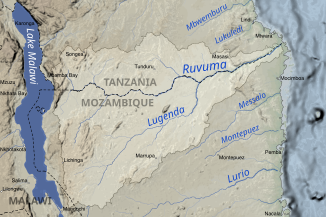
The Ruvuma catchment area |
||
| Data | ||
| location |
|
|
| River system | Rovuma | |
| source | east of Lake Malawi at Songea 10 ° 45 ′ 0 ″ S , 35 ° 40 ′ 0 ″ E |
|
| Source height | approx. 910 m | |
| muzzle | south of Mtwara in the Indian Ocean Coordinates: 10 ° 28 ′ 28 " S , 40 ° 26 ′ 13" E 10 ° 28 ′ 28 " S , 40 ° 26 ′ 13" E
|
|
| length | approx. 760 km | |
| Catchment area | 155,500 km² | |
| Left tributaries | Muhuwesi , Lumesule , Mbangala | |
| Right tributaries | Brass , Lucheringo , Lugenda | |
The Rovuma (other spellings Ruvuma , Rowuma ) is an approximately 760 km long river in East Africa . In its middle and lower reaches, the Rovuma forms the border between Tanzania and Mozambique over a length of around 650 kilometers .
geography
The Rovuma rises east of Lake Malawi (Njassasee) in Tanzania near Songea at 10 ° 45 ′ 0 ″ S, 35 ° 40 ′ 0 ″ E and flows between the Tanzanian coastal town of Mtwara and Cape Delgado at 10 ° 28 ′ 28 ″ S, 40 ° 26 ′ 13 ″ E in the Indian Ocean .
The most important tributaries on the Tanzanian side are Muhuwesi and Lumesule and Lucheringo and Lugenda in Mozambique. The unified bridge at Negomane , which opened in May 2010, is the only possible crossing for vehicles along the river.
The catchment area of the Ruvuma has, depending on the source, a size of 152,200 km² to 155,500 km, of which approximately 105,500 km² are located on Tanzanian territory.
fauna
59 species of fish have been identified in the Rovuma. The most species-rich group are the carp fish with 19 species, including 15 Barbus species and three Labeo species. The following are the catfish-like with four Mochokiden , two catfish - Quappenwels - Glass catfish - and a Stachelwelsart that cichlids , with eight species, and the Cyprinodontiformes four Nothobranchius and two Aplocheilichthys species. There are also five Mormyrids , five tetra , two gobies , one sleeper goby , an eel and a ear fish in the Rovuma.
history
The crossing of the Rovuma on November 25, 1917 is a military-historical event of the First World War in East Africa . As a result, the commander-in-chief of the German Schutztruppe for German East Africa , Paul von Lettow-Vorbeck , escaped premature surrender and continued to fight partly on opposing territory until the end of the First World War.
After the end of German East Africa , the mouth of the Rovuma formed the border between the British Mandate Tanganyika and Portuguese East Africa . Before that, a small area south of the estuary, the so-called Kionga triangle , belonged to German East Africa.
additional
Oil was found in front of the estuary delta.
See also
Individual evidence
- ↑ a b Ruvuma River. In: Encyclopædia Britannica . Retrieved December 28, 2013 .
- ↑ a b Ruvuma and Southern Coast Basin Water Board ( Memento of the original from March 22, 2016 in the Internet Archive ) Info: The archive link was inserted automatically and has not yet been checked. Please check the original and archive link according to the instructions and then remove this notice. , accessed June 4, 2015
- ↑ Mikiyasu Nakayama (Ed.): International Waters in Southern Africa (Water Resources Management and Policy) . United Nations Univ Pr, ISBN 978-92-808-1077-6 , pp. 9 ( google.com ).
- ↑ Rovuma . In: Encyclopædia Britannica . 11th edition. tape 23 : Refectory - Sainte-Beuve . London 1911, p. 782 (English, full text [ Wikisource ]).
- ↑ Strengthening Climate Information and EWS in Tanzania for Climate Resilient Development and Adaptation to climate change Project in Tanzania
- ↑ Lothar Seegers: The fish of the Ruvuma River, East Africa. In: Aquaristik Fachmaganzin, No. 170 April / May 2003, Tetra, Berlin, ISSN 1437-4854
- ↑ Ruvuma Basin - Basic Factfile
