
Ruker Province
The Ruker Province is a kratonized geological unit in East Antarctica . The age can be traced back to the Archean of up to approx. 3900 mya . The earliest protoliths (parent rocks) crystallized out around 3390 mya. The granitic - orthogneissic basement of the southern Prince Charles Mountains formed from them, overlaid by a mighty sequence of metasediments . Various intrusions penetrated into these several times . Metamorphoses had a relatively moderate impact on the rock packages. The mountains protruding from the ice cover reach heights of over 2000 meters.
Extension

Map of Antarctica

Location of the Enderbyland with the Napier complex, the Rayner province and the Lützow-Holm complex
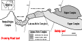
Simplified geological map of the Enderbyland

Prince Charles Mountains, Lambert Glacier and Amery Ice Shelf


The mountains and rock formations of the Ruker Province protruding from the ice cover form the southern Prince Charles Mountains. It connects to the southern areas of the northern Prince Charles Mountains with the Rayner Province . In the direction of the continental margin extending Lambert trench divides the Ruker province in two Terranes that Ruker-Terran and Lampert-Terran. You are in Mac Robertson Land , the Lambert Terran can also be assigned to Princess Elisabeth Land . The latter adjoins the Ruker Terran to the northeast. Large areas of the province are covered by a thick layer of ice.
Geodynamic development
The earliest geological events have been dated to approx. 3900 to 3800 mya using the samarium-neodymium method (Sm-Nd method). They refer to the development of tonalite - trondhjemite - granodiorite associations that typically formed archaic TTG complexes . New earth crust arose from them , from which the granitic-orthogneissic basement of the Ruker province was formed.
Mighty supracrustal rock sequences of different compositions were deposited on the crystalline basement of granites and orthogneiss . Deformations and crust compressions mostly produced moderate metamorphoses.
Individual granites and orthogneiss are the oldest Antarctic rocks that have not undergone multiple metamorphoses and have thus largely retained their original structures and textures .
The Ruker Terran and the Lambert Terran show certain different geodynamic developments and differ in terms of their geological history.
Ruker Terran
- Tektono-igneous events
Protoliths intruded into the basement several times. The oldest protoliths (parent rocks) were tonalitic Trondhjemites , which crystallized between 3390 and 3380 mya. They probably came from a mafic melt. Around 3180 and 3160 mya, protoliths of granitic orthogneiss formed. Further magma developments took place between 2900 and 2800 mya.
Between 2790 and 2770 mya, the only archaic tectono-thermal events took place with deformations and crust compressions as well as metamorphic overprints with formation of amphibolite facies . In the area of the southern Mawson Escarpment , which is assigned to the Ruker Terran, shear zones developed around 2790 mya .
Also in the southern Mawson Escarpment, post-tectonic muscovite-containing pegmatitic dykes rose by 2645 mya . They were not deformed and thus document the minimum age of archaic deformations and metamorphoses. Granitic dykes developed around 2500 mya in the southern Mawson Escarpment.
Before 2200 mya protoliths of granitic orthogneiss emerged in regional areas. Around 2200 mya metamorphoses occurred regionally, which led to moderate rock formation from green schist facies to amphibolite facies . In the period around 2100 mya and around 1708 mya, regional pegmatitic dykes rose again. Like those of 2645 mya, they penetrated the supracrustal rock sequences.
- Sedimentary units
Five spatially separated lithostratigraphic units developed in the Ruker Terran . They form Supracrustal rock sequences consisting essentially of quartzites , Metakonglomeraten , meta pelites and meta volcanic exist. They have ages between the Mesoarchean of approx. 3200 mya to the Paleoproterozoic of approx. 2100 mya. The last unit originated in the Neoproterozoic around 950 mya. All units were subject to different metamorphoses and deformations.
Lampert Terran

Landsat satellite map of the Lambert Glacier and the surrounding area
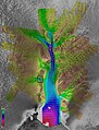
Satellite image of the Lambert Glacier with flow velocities marked in color

Satellite image of South Mawson Escarpment , Mac Robertson Land

Satellite image of northern Mawson Escarpment, Mac Robertson Land


The Lampert Terran is separated from the Ruker Terran and Rayner Province in the northern Prince Charles Mountains by the Lampert Trench. This trench represents a wide, approx. 1000 km long intracontinental rift valley, which runs almost perpendicular to the continental margin and flows into Prydz Bay . It developed from the Carboniferous around 300 mya and is traversed by the Lambert Glacier, which flows into the Amery Ice Shelf . This glacier is the largest and longest ice flow in the world .
The eastern flank of the Lambert Terran extends along the Lambert Trench and forms the central and northern Mawson Escarpment there . This terran is an approx. 150 kilometer long and up to 1 kilometer high steep edge that emerged when Proto-East Antartica separated from Greater India. Before the collapse of Gondwana, Greater India was made up of the land masses of India , eastern Madagascar , Sri Lanka and the Seychelles (see also → Greater India ).
The Lambert Trench was originally connected to the East Indian Mahanadi Trench or Mahanadi Basin in the Eastern Ghats .
- Tektono-igneous events
The tectono-magmatic evolution of the Lambert Terran can be traced back to 3520 mya when the first protoliths of granitic orthogneiss developed. Further magmatic intrusions followed around 2470 and 2420 mya. The ascended magmas formed larger, two-dimensional sequences from a multitude of relatively thin layers or compact massifs .
Particularly characteristic are powerful metamorphic complexes consisting of mafic mica schists or meta gabbros , associated with paragneiss, marbles and local, tectonically broken ultramafic blocks. They occur predominantly in northern terran areas. The settlement of these complexes was dated between 2400 and 2150 mya by means of zirconium analysis.
Felsic dykes rose around 2200 mya. This was followed at around 2120 mya by protoliths that were metamorphically overprinted to orthogneiss between 2065 and 2000 mya. Other large Felsic Dykes swarms appeared around 1470 mya.
Granites containing muscovite formed around 500 mya.
- Sedimentary units
Early Paleoproterozoic sedimentation processes probably occurred in the period between 2400 and 2000 mya, which was determined from data from some paragneiss. The deposited sediment sequences consist predominantly of metapeltites, meta psammites , calcareous silicate rocks and marbles.
Fossil acritarcha were found in metasediments , the ages of which date back to the Mesoarchaic or Mesoarchaic / Neoproterozoic .
Web links
- EV Mikhalsky: The Tectogenesis Stages of the Antarctic Shield: Review of Geochronological Data. In: Moscow University Geology Bulletin, 2007, Vol. 62, No. 3, pp. 143-154, 2007. doi: 10.3103 / S0145875207030027 , PDF ; 414 kB
- Evgeny V. Mikhalsky, Anatoly A. Laiba, and Boris V. Beliatsky: Tectonic Subdivision of the Prince Charles Mountains: A Review of Geologic and Isotopic Data. In: Chapter 9, pp 69-81 in the book Antarctica. doi: 10.1007 / 3-540-32934-X_9 PDF ; 1.2 MB
- Prince Charles Mountains. In: Australian Antarctic Division: Leading Australia's Antarctic Program. Online article
Individual evidence
- ↑ Evgeny V. Mikhalsky, Boris V. Belyatsky and Norbert W. Roland: New Evidence for Palaeoproterozoic tectono-Magmatic Activities in the Southern Prince Charles Mountains, East Antarctica. In: Polarforschung 78 (3), 85 - 94, 2008 (published 2009). PDF ; 1.6 MB
- ↑ Mat Harrowfield, Guy R. Holdgate, Christopher JL Wilson and Stephen McLoughlin: Tectonic significance of the Lambert graben, East Antarctica: Reconstructing the Gondwanan rift. In: Geology; 33 (3): 197-200. doi: 10.1130 / G21081.1 , PDF ; 1.0 MB
- ↑ F. Lisker, H. Gibson, CJ Wilson and A. Läufer: Denudation and uplift of the Mawson Escarpment (eastern Lambert Graben, Antarctica) as indicated by apatite fission track data and geomorphological observation. In: US Geological Survey and The National Academies; USGS OF-2007-1047, Short Research Paper 105. doi: 10.3133 / of2007-1047.srp105 , alternative , PDF; 1.4 MB