
Süssbach (Aare)
|
Süssbach upper course: Scherzbach |
||
 Süssbach bei Hausen with a railway bridge; right pillar of the road bridge |
||
| Data | ||
| Water code | CH : 1971 | |
| location | Switzerland | |
| River system | Rhine | |
| Drain over | Aare → Rhine → North Sea | |
| source | at Scherz AG | |
| Source height | approx. 505 m above sea level M. | |
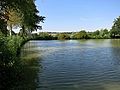
| muzzle | at the former Brugg power station in the Aare Coordinates: 47 ° 29 ′ 2 ″ N , 8 ° 11 ′ 59 ″ E ; CH1903: 657 371 / 259 525 47 ° 29 '2 " N , 8 ° 11' 59" O |
|
| Mouth height | approx. 332 m | |
| Height difference | approx. 173 m | |
| Bottom slope | approx. 27 ‰ | |
| length | 6.3 km | |
The Süssbach is a brook in the Brugg district in the Swiss canton of Aargau and a right tributary of the Aare .
location
The Süssbach rises southwest of the village of Scherz in the wooded hilly area between Birr in the east and Schinznach-Bad and Holderbank in the west. It flows through Scherz and over the Birrfeld into the area with the old field name Pfoltern and from there between the Guuggerhübel (or Scherzberg) and the Schofberg in the south-north running valley near Hausen . Then it touches the municipality of Windisch and flows into the Aare near Brugg .
The brook crosses the heavily transformed cultural landscape in the Birrfeld and in the agglomeration of Brugg. With the exception of the source brooks, almost the entire length of it is laid in an artificial brook bed , which has a variety of designs.
While the catchment area of the brook in the south and west on the ridges from Chestenberg to Wülpelsberg near Habsburg and also in the north-east with the hills near Hausen and Windisch is clearly delimited, the conditions on the Birrfeld in the south-east are more complicated. Although this area, created as an alluvial fan in the last Ice Age , has a gradient of around 30 meters from the southern edge near Brunegg and Birrhard to Süssbach near Hausen, no rivers form on it, because the precipitation seeps through the mighty gravel body and mostly flows into it as groundwater the valley of the Reuss , so flow to the east.
course
The Süssbach feeds above Scherz, where it is also called Scherzbach , two ponds, from which the operating energy for the Scherzer Mühle was obtained, the Upper Pond and the Büselweiher. In the village of Scherz it lies in a wide concrete canal with a rectangular cross-section. He crosses the road from Birr to Schinznach-Bad in a dole . Then it flows in a straightened canal, on which another pond has been created, over the gently sloping open terrain on the western edge of the Birrfeld plain. The fortified river bed has many small steps to reduce erosion. The municipal boundary between Scherz and Lupfig follows the left edge of the canal for a while.
The Süssbach now reaches the company premises of the AMAG vehicle logistics center in Birrfeld, where it receives its greatest inflow from the right, a side stream that is also laid in a straight canal, which corresponds to the former Bachthalengraben. This channel collects the four streams of Birr and Lupfig, which are overturned in the settlement area and up to this main channel in the plain.
After changing direction to the north, the Süssbach Canal leaves the AMAG area and crosses under the A 3 motorway in a concrete canal built in 1989 and flows around 200 meters to the east alongside the motorway. On the eastern foothills of the Guggerhübel, in addition to the switchgear of Industrielle Betriebe Brugg, it also encounters three bridges: the road bridge for the north access to the AMAG site, the high bridge for the Hausen motorway feeder (road number 296), which at this point overlooks the stream, the Brugg railway line - Othmarsingen and the Autobahn crossed, and the bridge of this railway line with two passages for the Süssbach. A pull-out track of the piggyback terminal in Birrfeld, built around 2011, severely narrows the stream bed east of the railway bridge.
In addition to the site of the former Hausen cement factory and on the western edge of the von Hausen settlement, the Süssbach follows the gravel plain at a small distance from the railway line, which descends here from Birrfeld in an incision that is steadily deeper towards the north to Brugg station 40 meters below , and thus lies north of Hausen around 10 meters higher than the railroad tracks just a few meters away. A stream flowing from Habsburg through the Buligraben to the east crosses the motorway feeder at the hamlet of Holzgasse and the railway line in a canal bridge and is the only noteworthy left tributary to flow into the Süssbach near Hausen.
On the 2.3 kilometer stretch from Hausen, the Bach Canal also gradually deepens in a straightened trench with a paved floor. Numerous public and private bridges cross the canal, including the footbridges of the Süssbachweg . To stimulate the flow dynamics, widenings have recently been created in places and sturgeon stones have been placed on the bottom of the canal.

After the border with the municipality of Windisch, the brook flows for a short time in a valley that still partially corresponds to the original course of the brook, along the Bachweg from Windisch and past the densely built-up Weihermatt and near the remains of the Roman amphitheater until it reaches the station district . Five bridges and footbridges as well as a canal bridge lead across the small valley. In this section, too, the actual streambed is completely built with paving, embankment walls and sills . After periods of low precipitation, the Süssbach can fall dry in this part of the lower reaches due to the sinking groundwater level due to the seepage of the water.
The stream flows under the following factory site of Kabelwerke Brugg in a dole, which it leaves again at the municipal border between Windisch and Brugg after Industriestrasse, and then in an open, concreted stream bed about 50 meters to a tunnel under the track field west of the Brugg train station. In front of the tunnel entrance is the pipe mouth of a drainage canal in the industrial area on Lagerstrasse, which can be shut off with a slide.
The approximately 100 meter long, angled Süssbach tunnel under the tracks and under Hauptstrasse 5 follows the border line between Brugg and Windisch and contains the Süssbach and a pedestrian passage next to each other and only separated by a high concrete wall. The tunnel vault has two openings in the middle of the track field, where there are larger distances between the tracks. After a passage for the Süssbach had already been established in 1858 for the railway line from Aarau to Baden , the longer Bachtunnel was created when the additional tracks were built for the connecting line from Brugg to Hendschiken of the Aargau Southern Railway in 1882. Later road and track extensions were replaced by the The tunnel in front of both portals was slightly longer.
At the tunnel exit is an artificial creek bed, built between 1925 and 1950, which runs with increasing incline and over small steps through the Brugg residential and commercial area west of the station district with the Bachstrasse and the Süssbachweg and next to the Brugg Medical Center , the former Brugg Hospital , runs to Laurstrasse . Numerous road bridges and footbridges lead across the ravine, the bottom of which and the slope of which are secured with large stone slabs. The bridge on Frickerstrasse bears a Bruges coat of arms relief dated 1925.
From the embankment of Laurstrasse, the Süssbach flows in the last section of its course through a large underground canal that is secured with shut-off and overflow devices. The channel, built around 1925, runs deep in the ground across the Laurstrasse, Freudensteinstrasse and Museumsstrasse or Marie-Heim-Vögtlin-Weg and flows into the Aare next to the former Brugg power station built in 1892 on the Aare promenade. The last part of the Süssbach valley up to the Aare has been partially filled up to the level of the terrain terrace after the construction of the upper water canal.
history
From Birrfeld via Hausen to Brugg, two underground water pipes were built near the Süssbach in Roman times , which led the drinking water to the settlement with the legionary camp of Vindonissa (see Vindonissa water pipes ). The water intake of the older Roman Canal is likely to have been in the Scherz area and was fed from springs on the upper reaches of the Süssbach.
In the 19th and 20th centuries, floods in the Süssbach repeatedly damaged the infrastructure in Scherz and Hausen.
From Scherz to Windisch, the sewer pipeline built around 1967 called the Birrfeld sewer follows the Süssbach. The canal leads below Brugg to the Brugg-Birrfeld sewage treatment plant in Aareschachen.
photos
Büselweiher at Scherz

Arch bridge on Werkhofstrasse at the Hausen schoolhouse
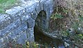
Bridge from the 19th century over the Süssbach Canal near Hausen

Süssbach tunnel with footpath under the track field near Brugg
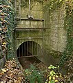
Süssbachdole in Brugg


Individual evidence
- ↑ Pull-out track in the stream bed In: Aargauer Zeitung from November 15, 2011. Accessed on November 3, 2016.
- ↑ Site plan on the Aare, 2011
- ↑ Franz B. Maier: The so-called "older" or "earlier" Roman aqueduct to the Roman legion camp Vindonissa. In: Annual Report of the Society for Vindonissa. 1990, pp. 43-47.
- ↑ Brugg sewage treatment plant