
Sály
| Sály | |||||
|
|||||
| Basic data | |||||
|---|---|---|---|---|---|
| State : | Hungary | ||||
| Region : | Northern Hungary | ||||
| County : | Borsod-Abaúj-Zemplén | ||||
| Small area until December 31, 2012 : | Mezőkövesd | ||||
| District since 1.1.2013 : | Mezőkövesd | ||||
| Coordinates : | 47 ° 57 ' N , 20 ° 40' E | ||||
| Height : | 142 m | ||||
| Area : | 25.56 km² | ||||
| Residents : | 2,147 (Jan. 1, 2011) | ||||
| Population density : | 84 inhabitants per km² | ||||
| Telephone code : | (+36) 49 | ||||
| Postal code : | 3425 | ||||
| KSH kódja: | 04729 | ||||
| Structure and administration (status: 2018) | |||||
| Community type : | local community | ||||
| Mayoress : | Jánosné Fekete (independent) | ||||
| Postal address : | Kossuth Lajos u. 63. 3425 Sály |
||||
| Website : | |||||
| (Source: A Magyar Köztársaság helységnévkönyve 2011. január 1st at Központi statisztikai hivatal ) | |||||


Sály is a Hungarian community in the county Mezőkövesd in Borsod-Abaúj-Zemplén .
Geographical location
Sály is located in northern Hungary on the southeastern foothills of the Bükk , about 20 kilometers southwest of the Miskolc county seat , on the small Sályi-patak river . Neighboring communities are Borsodgeszt , Kács , Tibolddaróc and Bükkábrány .
Attractions
- Sály Vízfő Nature Trail ( Sály Vízfő-tanösvény )
- Reformed church, built 1825–1850
-
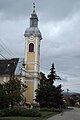
Roman Catholic Church Szűz Mária Keresztények Segítsége , built around 1790 (late baroque)
- In front of the entrance to the church there is a statue of I. Szent István király and a statue of Árpád-házi Szent Erzsébet .
- Castle Eötvös Gorove ( Eötvös Gorove-kastély )
traffic
The side road No. 25115 runs through Sály. The nearest train station, Mezőkeresztes - Mezőnyárád, is a good ten kilometers south of the municipality.
photos

reformed Church

Gravestones in the garden of the Reformed Church
Roman Catholic Church Szűz Mária Keresztények Segítsége

View of the Eötvös-Gorove Castle

Memorial plaque for József Eötvös at the castle

Monument in the garden of the castle


.jpg)
Web links
- Official website of Sály ( Hungarian )
- Sály at tourinform.hu
- A sályi református templom (Hungarian)
- Aerial views over Sály