Samalari (Laga)
| Samalari | ||

|
||
| Data | ||
| surface | 24.64 km² | |
| population | 2,677 (2015) | |
| Chefe de Suco | Luis Clementino Xavier (election 2016) |
|
| Aldeias | Population (2015) | |
| Desagua | 158 | |
| Lalu Uai | 1,214 | |
| Lualari | 272 | |
| Sae Uata Issi | 15th | |
| Samalari | 398 | |
| Sorugua | 603 | |
| Ueru-Mata | 17th | |
|
|
||
Samalari is an East Timorese place, Aldeia and Suco in the administrative office of Laga ( municipality of Baucau ). "Samalari" means " banyan tree " in Makasae .
The place
The place Samalari is located in the south of the Sucos, at an altitude of 476 m . The Sucos primary school is located here.
The Suco
| Samalari | ||
| places | position | height |
| Bubodefo | 8 ° 29 ′ S , 126 ° 40 ′ E | 440 m |
| Lalu Uai | 8 ° 30 ′ S , 126 ° 41 ′ E | 553 m |
| Larisula | 8 ° 29 ′ S , 126 ° 40 ′ E | 522 m |
| Laucolo | 8 ° 28 ′ S , 126 ° 40 ′ E | 406 m |
| Lualari | 8 ° 28 ′ S , 126 ° 40 ′ E | 406 m |
| Samalari | 8 ° 29 ′ S , 126 ° 40 ′ E | 476 m |
| Sorugua | 8 ° 29 ′ S , 126 ° 40 ′ E | 476 m |
Samalari has 2677 inhabitants (2015), of which 1318 are men and 1359 women. The population density is 108.6 inhabitants / km². There are 534 households in the Suco. About 95% of the population name Makasae as their mother tongue. About 5% speak Tetum Prasa .
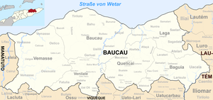
Before the 2015 regional reform, Samalari had an area of 15.99 km². Now there are 24.64 km². The Suco is in the northeast of the Laga Administrative Office on the Wetar Strait . To the east lies the Suco Nunira , southwest of the Suco Libagua , and to the southeast the Sucos Sagadate and Saelari . In the northeast, Samalari borders the Lautém administrative office ( Lautém municipality ) with its Suco Ililai . The Binagua River flows along part of the western border . Part of the border with Libagua is followed by the Assarini River , a tributary of the Lequinamos . On a piece of the border with Ililai the river flows Lalubuilana .
The northern coastal road, one of the country's most important transport routes, runs along the coast. A second overland road runs through the south, connecting the towns of Baucau and Baguia . The places Bubodefo , Samalari , Larisula and Lalu Uai ( Lalulai ) are located on it. A little further north are the villages of Sorugua ( Sorogua ), Laucolo and Lualari .
In the Suco there are the seven Aldeias Desagua , Lalu Uai , Lualari , Sae Uata Issi , Samalari , Sorugua and Ueru-Mata .
politics
In the elections of 2004/2005 was João de Deus Xavier elected Chefe de Suco and in 2009 re-elected. In the elections in 2016 won Luis Clementino Xavier .
Web links
- Results of the 2010 census for the Suco Samalari ( tetum ; PDF; 8.6 MB)
- Results of the 2015 census for the Suco Samalari (tetum; PDF)
- Seeds of Life: Suco information sheets Laga (tetum)
Individual evidence
- ↑ a b c d Direcção-Geral de Estatística : Results of the 2015 census , accessed on November 23, 2016.
- ↑ Geoffrey Hull : The placenames of East Timor , in: Placenames Australia (ANPS): Newsletter of the Australian National Placenames Survey, June 2006, pp. 6 & 7, ( Memento of the original from February 14, 2017 in the Internet Archive ) Info: The archive link was inserted automatically and has not yet been checked. Please check the original and archive link according to the instructions and then remove this notice. accessed on September 28, 2014.
- ↑ a b UNMIT: Timor-Leste District Atlas version 02, August 2008 ( Memento of the original dated December 3, 2011 in the Internet Archive ) Info: The archive link was inserted automatically and has not yet been checked. Please check the original and archive link according to the instructions and then remove this notice. (PDF; 499 kB)
- ↑ Fallingrain.com: Directory of Cities, Towns, and Regions in East Timor
- ↑ Results of the 2010 census for the Suco Samalari ( tetum ; PDF; 8.6 MB)
- ↑ Direcção Nacional de Estatística: Population Distribution by Administrative Areas Volume 2 English ( Memento of the original from January 5, 2017 in the Internet Archive ) Info: The archive link has been inserted automatically and has not yet been checked. Please check the original and archive link according to the instructions and then remove this notice. (2010 census; PDF; 22.6 MB)
- ↑ a b Timor-Leste GIS Portal ( Memento from June 30, 2007 in the Internet Archive )
- ↑ Jornal da Républica with the Diploma Ministerial n. 199/09 ( Memento of February 3, 2010 in the Internet Archive ) (Portuguese; PDF; 323 kB)
- ↑ Secretariado Técnico de Administração Eleitoral STAE: Eleições para Liderança Comunitária 2004/2005 - Resultados ( Memento of August 4, 2010 in the Internet Archive )
- ↑ Secretariado Técnico de Administração Eleitoral STAE: Eleições para Liderança Comunitária 2009 - Resultados ( Memento of August 4, 2010 in the Internet Archive )
- ↑ Jornal da República: Lista Naran Xefe Suku Eleito 2016 , December 2, 2016 , accessed on June 17, 2020.
