Samukawa (Kanagawa)
| Samukawa-machi 寒 川 町 |
||
|---|---|---|
|
|
||
| Geographical location in Japan | ||
| Region : | Kanto | |
| Prefecture : | Kanagawa | |
| Coordinates : | 35 ° 22 ' N , 139 ° 23' E | |
| Basic data | ||
| Surface: | 13.42 km² | |
| Residents : | 48,379 (October 1, 2019) |
|
| Population density : | 3605 inhabitants per km² | |
| Community key : | 14321-9 | |
| Symbols | ||
| Flag / coat of arms: | ||
| Tree : | Scented flower | |
| Flower : | Narcissus tazetta var. Chinensis | |
| Bird : | Great Egret | |
| town hall | ||
| Address : |
Samukawa Town Hall 165 Miyayama Samukawa - machi , Kōza-gun Kanagawa 253-0196 |
|
| Website URL: | http://www.town.samukawa.kanagawa.jp | |
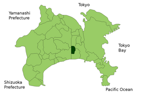
| Location of Samukawas in Kanagawa Prefecture | ||
Samukawa ( Japanese 寒 川 町 , -machi ) is a municipality in the district of Kōza in Kanagawa Prefecture in Japan .
Attractions
- Samukawa Shrine , the first shrine in Sagami Province .
- In Samukawa the ancient art of Yabusame archery is still practiced.
traffic
- Street:
- National roads 44, 45, 46, and 47
- Train:
- JR Sagami Line : Samukawa, Miyayama and Kurami Stations
Web links
Commons : Samukawa - collection of images, videos and audio files


