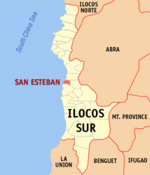
San Esteban (Ilocos Sur)
| Municipality of San Esteban | ||
 |
||
| Location of San Esteban in the province of Ilocos Sur | ||
|---|---|---|

|
||
| Basic data | ||
| Region : | Ilocos region | |
| Province : | Ilocos Sur | |
| Barangays : | 10 | |
| District: | 2. District of Ilocos Sur | |
| PSGC : | 012918000 | |
| Income class : | 5th income bracket | |
| Households : | 1482 May 1, 2000 census
|
|
| Population : | 8,349 August 1, 2015 census
|
|
| Population density : | 347.9 inhabitants per km² | |
| Area : | 24 km² | |
| Coordinates : | 17 ° 20 ′ N , 120 ° 26 ′ E | |
| Postal code : | 2706 | |
| Mayor : | Chester A. Elaydo | |
| Website: | www.sanesteban.com.ph | |
| Geographical location in the Philippines | ||
|
|
||
San Esteban is a municipality in the Philippine province of Ilocos Sur and is located on the South China Sea . In 2015, 8349 people lived in the area of just 24 km², resulting in a population density of 348 inhabitants per km². The terrain is often hilly and occasionally flat. San Esteban has several beaches and beautiful stone formations on the coast.
San Esteban is divided into the following ten barangays :
- Ansad
- Apatote
- Bateria
- Cabaroan
- Cappa-Cappa
- Poblacion
- San Nicolas
- San Pablo
- San Rafael
- Villa Quirino
