Tagudin
| Municipality of Tagudin | ||
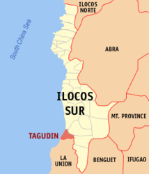
| Location of Tagudin in the province of Ilocos Sur | ||
|---|---|---|

|
||
| Basic data | ||
| Region : | Ilocos region | |
| Province : | Ilocos Sur | |
| Barangays : | 43 | |
| District: | 2. District of Ilocos Sur | |
| PSGC : | 012933000 | |
| Income class : | 3rd income bracket | |
| Households : | 6603 May 1, 2000 census
|
|
| Population : | 39,277 August 1, 2015 census
|
|
| Coordinates : | 16 ° 56 ' N , 120 ° 27' E | |
| Postal code : | 2714 | |
| Area code : | +63 77 | |
| Mayor : | Roque S. Verzosa | |
| Website: | www.tagudin.gov.ph | |
| Geographical location in the Philippines | ||
|
|
||
Tagudin is a municipality in the Philippine province of Ilocos Sur and is located on the South China Sea . In the south it borders on the province of La Union . The first two sundials in the Philippines, which are still there today, were built in Tagudin . There is also a beach, a lighthouse and two bridges in the municipality, one of which is named after the wife of the former president Elpidio Quirino . Most of the people who inhabit the flat area make a living from growing rice , fishing and weaving. The Amburayan River passes the community to the south.
Tagudin is divided into the following 43 barangays :
|
|
|
