Santo Domingo (Ilocos Sur)
| Municipality of Santo Domingo | ||
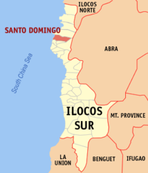
| Location of Santo Domingo in the province of Ilocos Sur | ||
|---|---|---|

|
||
| Basic data | ||
| Region : | Ilocos region | |
| Province : | Ilocos Sur | |
| Barangays : | 36 | |
| District: | 1. District of Ilocos Sur | |
| PSGC : | 012928000 | |
| Income class : | 4. Income bracket | |
| Households : | 4871 May 1, 2000 census
|
|
| Population : | 27,975 August 1, 2015 census
|
|
| Population density : | 480.7 inhabitants per km² | |
| Area : | 58.2 km² | |
| Coordinates : | 17 ° 38 ′ N , 120 ° 24 ′ E | |
| Postal code : | 2729 | |
| Area code : | +63 77 | |
| Mayor : | Floro J. Jadena | |
| Geographical location in the Philippines | ||
|
|
||
Santo Domingo is a municipality in the Philippine province of Ilocos Sur and is located on the South China Sea . In 2015 the area of 58.2 km² had 27,975 inhabitants, resulting in a population density of 481 inhabitants per km². The terrain is mainly very flat and only rises sharply in the extreme east due to the Cordilleras . Most of the inhabitants live from agriculture and fishing. The Environmental Research and Training Center of the University of Northern Philippines is located in the community.
Santo Domingo is divided into the following 36 barangays :
|
|
|
Web links
- www.stodomingo.gov.ph ( Memento from August 23, 2007 in the Internet Archive )
