
San Jose de Maipo
| San Jose de Maipo | ||
|---|---|---|
|
Coordinates: 33 ° 38 ′ S , 70 ° 21 ′ W San José de Maipo on the map of Chile
|
||
| Basic data | ||
| Country |
|
|
| City foundation | July 16, 1792 | |
| Residents | 13,376 (2002) | |
| City insignia | ||
|
|
||
| Detailed data | ||
| surface | 4,994.8 km 2 | |
| Population density | 3 people / km 2 | |
| Waters | Río Maipo , Río Colorado, Río El Yeso, Río El Volcán, Laguna Negra, Embalse El Yeso and many others | |
| Time zone | UTC −4 | |
| Website | ||
 |
||
 |
||
 |
||

San José de Maipo is a commune in the Andes of central Chile, between the capital Santiago and the border with Argentina . It has 13,376 inhabitants, 70% of whom live in the small town of the same name and 30% in numerous smaller villages. The municipal area of almost 5000 km² includes the entire catchment area of the Andean upper reaches of the Río Maipo with its tributaries. Located 800 to 5000 m above sea level, the area mainly consists of high and low mountain ranges with valleys cut deep by the rivers. The main economic activities are mining, tourism and livestock. The drinking water supply of Santiago and the irrigation of a large part of the Región Metropolitana takes place with the water that is taken in this municipality from the rivers Yeso and Maipo.

| ||||||||||||||||||||||||||
The municipality of San José de Maipo consists of many small settlements that line up along the rivers. There are some active volcanoes on the border with Argentina. The mountains shown on this map roughly mark the municipal boundaries. |
Districts of the municipality
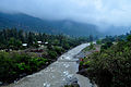
The municipality consists of numerous settlements, most of which are situated on terraced banks along the Río Maipo. There are 13 localities for which local boundaries are shown in the development plan of the Región Metropolitana. These include La Obra, Las Vertientes, El Canelo, El Manzano, Guayacán, San José de Maipo, Lagunillas, El Melocotón, San Alfonso, El Ingenio, San Gabriel, El Volcán and Baños Morales, which are here roughly as the distance from Santiago increases are listed. Taken together, these places cover an area of 12.4 km², which corresponds to 0.25% of the entire municipal area.
On the Río Maipo to San José
La Obra
La Obra (Spanish for: The Work ) ( 33 ° 36 ′ S , 70 ° 29 ′ W ), around 30 km from the center of Santiago, 800 m above sea level on the north bank of the Río Maipo , is practically the gateway to the municipality of San José de Maipo and to the Cajon del Maipo (Spanish for: Maipo Gorge). Coming from the neighboring municipality of Puente Alto , the Camino al Volcán (Spanish for: way to the volcano) leads through La Obra. This is the central street of the municipality that connects most of the districts and runs along the Río Maipo and Río Volcán almost to the San José volcano on the border with Argentina. An average of 800 vehicles per hour pass through La Obra on a normal working day.
The settlement was created in 1802 from a warehouse for the construction of an irrigation canal that starts from there. The place is still characterized by commercial activities and is known for its stonemasons who sell their work to tourists there.
Las Vertientes
Las Vertientes (Spanish for: The slopes ) ( 33 ° 35 ′ S , 70 ° 28 ′ W ), 1 km east of La Obra, is located on a flat slope in an extensive loop of the Río Maipo. The place is a garden district with 1037 inhabitants and thus the second largest settlement in the municipality. The settlement was created in 1941 from a subdivision of the Fundo Las Vertientes. There are first tourist offers on site. There is a bridge over the Maipo that connects to the south to the neighboring community of Pirque and to a road that runs along the south bank of the Maipo to El Toyo. Together with La Obra, Las Vertientes is de facto already part of the metropolitan area of Greater Santiago.
El Canelo
El Canelo (Spanish for: the cinnamon tree ) ( 33 ° 35 ′ S , 70 ° 27 ′ W ), around 3 km east of La Obra, is the first town that is no longer under the influence of the Metropolis. During the morning rush hour there are only a maximum of 218 vehicles per hour on the way to Santiago. In 1910 a 12 km long railway line from Puente Alto to El Canelo was completed. The former station building ( 33 ° 34 ′ 38 ″ S , 70 ° 27 ′ 1 ″ W ) has been preserved.
El Manzano
El Manzano (Spanish for: the apple tree ) ( 33 ° 35 ′ S , 70 ° 24 ′ W ) is located on the Río Maipo between the mouths of the Estero El Manzano and the Río Colorado. It is the largest and fastest growing district of San José de Maipo. In the historical core there are some old buildings, such as the customs station, the church with rectory of the former Fundo El Manzano and the ruins of the former train station ( 33 ° 35 ′ S , 70 ° 24 ′ W ). Upstream at Estero El Manzano, the oldest traces of human existence were found in the Cajon del Maipo, 10,000 years old. There are 20 prehistoric archaeological sites along this river.

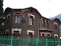
Former customs house in El Manzano. Mud brick house, built around 1830 to 1840 as a mansion for Fundo El Manzano, auctioned in 1870, used for border clearance since the beginning of the 20th century, closed in 1973. ( 33 ° 35 ′ 12 ″ S , 70 ° 23 ′ 25 ″ W )
Church and rectory of the former Fundo El Manzano. Mud-brick building with oak beam structure and fired brick floor. ( 33 ° 35 ′ 15 ″ S , 70 ° 23 ′ 24 ″ W )
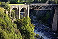
Historic railway bridge over the Río Colorado between El Manzano and Guayacán. ( 33 ° 35 ′ 36 ″ S , 70 ° 22 ′ 14 ″ W )


Guayacan
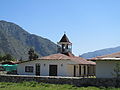
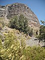
Guayacán (Spanish for: guaiac tree ) ( 33 ° 36 ′ S , 70 ° 21 ′ W ), 950 m above sea level, 950 inhabitants.
San Jose de Maipo
San José de Maipo ( 33 ° 38 ′ S , 70 ° 21 ′ W ), 970 m above sea level, small town and administrative center with 5281 inhabitants.
City Hall ( 33 ° 38 ′ 26 ″ S , 70 ° 21 ′ 13 ″ W ) in the Plaza de Armas.

Old hospital.

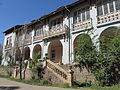
Former Laennec sanatorium ( 33 ° 38 ′ 29 ″ S , 70 ° 21 ′ 7 ″ W ) adobe house built 1894–1896, initially a hotel for those seeking relaxation, from 1920 a sanatorium, supplemented in 1926 with an extension, today the administration of the municipal hospital.
Casa de Salud de Mujeres Carolina Doursther. ( 33 ° 38 ′ 38 ″ S , 70 ° 21 ′ 1 ″ W ) Built in 1870 as a private resort. Donated in 1911 for the establishment of a tuberculosis sanatorium, which was opened in 1919. A second house was added in 1944 and is now part of the municipal hospital.


Lagunillas
Lagunillas (Spanish for: pond ; 33 ° 36 ′ S , 70 ° 17 ′ W ) is a ski center in the mountains above San José. Only three residents were counted in the only seasonally operated tourist complex at an altitude of 2250 m with an area of 47 hectares. The Club Andino de Chile and the Carabineros de Chile each maintain a refuge there. Lagunillas is located in the middle of a nature reserve that extends west of San José over 134 km².
On the Colorado River
Los Maitenes
Los Maitenes (Spanish for: Maytenus boaria trees ; 33 ° 32 ′ S , 70 ° 16 ′ W ), 1200 m above sea level, 12 km northeast of El Manzano, 149 inhabitants. The place was originally built as a settlement for the Los Maitenes hydropower plant (1918 to 1922, 5 generators with a total of 30.8 MW ( 33 ° 31 ′ 51 ″ S , 70 ° 15 ′ 42 ″ W ) and ( 33 ° 32 ′ 5 ″ S , 70 ° 15 ′ 20 ″ W )) with a village square, general store, school, chapel, company doctor, works canteen and residential buildings. The settlement and the factory were badly damaged by a mudslide in 1987. Next to the village is the former mansion of the Hacienda Río Colorado ( 33 ° 32 ′ 14 ″ S , 70 ° 15 ′ 59 ″ W ), today a holiday center of the Carabineros . The hacienda with an area of 1175 km² belongs to the Chilean army and serves, among other things, as a military training area and an agricultural enterprise.
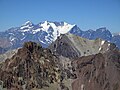
The landscape here is characterized by particularly steep walls of the Colorado Gorge.

Mountains at Los Maitenes.
Mountains at Los Maitenes.


El Alfalfal
El Alfalfal (Spanish for: The Kleefeld ) ( 33 ° 30 ′ S , 70 ° 12 ′ W ), 1330 meters above sea level, 7 km northeast of Los Maitenes, is a factory settlement with 98 inhabitants that is part of the hydroelectric power station of the same name (2 generators , 160 MW in operation since 1991.) belongs. The public road ends there. The entrance to the plant is the control point for the access to the Cordillera northwest of it, which is largely owned by the Chilean military. With the approval of the Ministry of Bienes Nacionales, you can get to the Cajón del Olivares or the Tupungatito volcano from there . The Fundación Sendero de Chile (Foundation Hiking Chile) maintains a refuge on the Río Olivares ( 33 ° 24 ′ S , 70 ° 8 ′ W ) which serves as a center for logistical support for activities and emergencies in the area. Six administrative staff can receive up to 40 visitors there.

The Río Olivares, a tributary of the Río Colorado, has its source at a spectacular waterfall that is fed by a glacier. This picture shows only a small part of it. ( 33 ° 10 ′ S , 70 ° 7 ′ W )
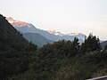
About 50 km from Alfalfal, through the valley of the Río Olivares, one reaches the Cerro Juncal on the northern municipal border. Behind it lies Argentina.

The Tupungato cone and in the foreground the Tupungatito crater are an active volcanic center. The water from the glaciers forms the Río Colorado.


On the Río Maipo from San José to San Gabriel
El Toyo
El Toyo (Spanish for: undergrowth or pool ) ( 33 ° 40 ′ S , 70 ° 21 ′ W ), 3.5 km south of San José, 990 m above sea level, with 141 inhabitants, is one of two villages in the municipality which lie on the left bank of the Maipo. A rustic suspension bridge and a modern road bridge connect the place with the main artery Camino al Volcán. Via the Camino El Toyo, which runs along the left bank of the Maipo, you have a connection to Las Vertientes at the entrance to the Cajon del Maipo and to the neighboring community of Pirque.

El Toyo, named after the Fundo El Toyo, which extends over an area of 190 km² between the Río Maipo and the western municipal border.
A suspension bridge for intrepid pedestrians in El Toyo. ( 33 ° 40 ′ 9 ″ S , 70 ° 20 ′ 57 ″ W ) According to a local legend, the builder of the bridge successfully challenged the devil. The angry devil then kicked the opposite rock. This is how the vernacular explains the fossilized dinosaur footprints that are found there.
.jpg)

El Melocotón
El Melocotón (Spanish for: the peach tree ) ( 33 ° 42 ′ S , 70 ° 20 ′ W ), 6 km south of San José, 1060 m above sea level, with 580 inhabitants. The place originally served as pastureland for the donkey drivers of the zone and over time it developed into a settlement. There is a mud-brick church built in 1903 ( 33 ° 43 ′ S , 70 ° 20 ′ W ). The railway reached El Melocotón in 1911. The historic station was renovated by railway enthusiasts and is open to the public.

Estación El Melocotón ( 33 ° 41 ′ 37 ″ S , 70 ° 20 ′ 8 ″ W ) Today an attraction, at the beginning of the 20th century an important transport link. The journey time by steam locomotive from Puente Alto was 45 minutes for the 13.5 km to El Canelo at the entrance of the Cajon del Maipo, two hours for 35.8 km to El Melocotón and three and a half hours for 61.9 km to the final stop in El Volcán.
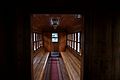
Restored passenger car in El Melocotón station. In the first half of the 20th century, those seeking relaxation could travel to the eight train stations in San José de Maipo in such vehicles.

Restored passenger car in El Melocotón station.


San Alfonso
San Alfonso ( 33 ° 44 ′ S , 70 ° 19 ′ W ), 1129 m above sea level, with 768 inhabitants, is traditionally a tourist destination with large-scale projects such as B. Cascada de Las Ánimas (Spanish for: Waterfall of Souls ), a private holiday and leisure center with a nature park, named after a waterfall of the same name. An average traffic flow of 80 vehicles per hour is registered in San Alfonso.

Cascada de Las Ánimas, the waterfall after which the nature reserve is named. ( 33 ° 44 ′ S , 70 ° 19 ′ W )

Suspension bridge for pedestrians over the Río Maipo.


Near San Alfonso, the historic narrow-gauge railway line of the Ferrocarril Militar de Puente Alto al Volcán was led through the 430 m long El Tinoco tunnel ( 33 ° 45 ′ S , 70 ° 17 ′ W ). The tunnel shortens the path through a rock barrier, around which the Río Maipo flows in a particularly narrow loop, called Vuelta del Padre ( 33 ° 45 ′ S , 70 ° 17 ′ W ), with an increased gradient.
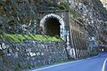
El Tinoco tunnel, western entrance.

Inside the western tunnel entrance.
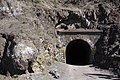
El Tinoco tunnel, eastern entrance.


El Ingenio
El Ingenio (Spanish for: the genius ) ( 33 ° 46 ′ S , 70 ° 17 ′ W ) is a resort on the left bank of the Maipo which was created in 1950 from a parceling out.
.jpg)
Other settlements on the right bank of the Maipo near El Ingenio are:
- El Boyenar (also El Bollenar; Spanish for: Bollén-Baum-Feld ) ( 33 ° 45 ′ S , 70 ° 17 ′ W ) is a village in which 58 families live.
- El Almendro (Spanish for: the almond tree ) 33 ° 46 ′ S , 70 ° 16 ′ W , 1120 m above sea level, approx. 4 km northwest of San Gabriel across from El Ingenio.
San Gabriel
San Gabriel ( 33 ° 47 ′ S , 70 ° 14 ′ W ) at 1260 m altitude, at the confluence of the Río Yeso into the Río Maipo, is a communal sub-center with the character of an enclave on the border. This is where the asphalt part of the Camino al Volcán ends and there is a police station with which access to the further cordillera is controlled. In the courtyard of the police station there is a trigonometric point that is used to map the region. There is a boarding school where students from the scattered settlements of the commune are accepted.
San Gabriel belonged to the settlement area of the Chiquillane, a nomadic people in the central Andean region who left an indigenous cemetery here. Today's village was formed around the train station.
Individual evidence
- ↑ a b Instituto Nacional de Estadistica, Censo 2002 ine.cl (accessed on March 31, 2014)
- ↑ a b c d e f g h i j k l m n o p Dirección de servicios externos - Facultad de Arquitectura, Diseño y estudio urbanos: Actualización y Adecuación del Plan Regulador Comunal de San José de Maipo. Memoria Explicativa . Ed .: IM San José de Maipo. ( sanjosedemaipo.cl [PDF; accessed on March 21, 2014]).
- ↑ a b c d e f g h i j k Diccionario de la lengua española. Real Academia Española, accessed June 28, 2014 .
- ↑ a b c d e f g h i j k l m n o p q r s t u v w x y z aa ab ac ad ae af ag ah Coordinates determined with the help of Google Earth, 2014.
- ↑ a b c d Shakti Feuerhake González: Estrategía urbano territorial para el Cajón del Maipo. Infraestructuras Urbanas como Instrumentos de Planificación, Comuna de San José de Maipo . In: Tesis Proyectual para optar al título de Arquitecto y Magíster en Desarrollo Urbano, Pontificia Universidad Católica de Chile . Santiago de Chile November 2008 ( online [PDF; accessed April 8, 2014]). Estrategía urbano territorial for the Cajón del Maipo. Infraestructuras Urbanas como Instrumentos de Planificación, Comuna de San José de Maipo ( Memento of the original from March 4, 2016 in the Internet Archive ) Info: The archive link was inserted automatically and has not yet been checked. Please check the original and archive link according to the instructions and then remove this notice.
- ^ Luis E. Cornejo B .: Asentamientos del Complejo Aconcagua en El Manzano . Estudios en un sitio agonico. In: Actas del 2 ° Taller de Arqueología de Chile Central . 2004 ( arqueologia.cl [PDF; accessed on April 21, 2014]).
- ↑ Gobierno de Chile (ed.): Decreto exento . Declara monumento histórico la aduana El Manzano, ubicada en la comuna de San José de Maipo, Región Metropolitana. November 5, 2004 ( monumentos.cl [PDF; accessed June 28, 2014]). monumentos.cl ( Memento of the original from March 4, 2016 in the Internet Archive ) Info: The archive link was inserted automatically and has not yet been checked. Please check the original and archive link according to the instructions and then remove this notice.
- ^ Capilla y casa del Ex Fundo El Manzano. (Capilla). Consejo de Monumentos Nacionales de Chile, Retrieved June 28, 2014 (Spanish).
- ^ Capilla y casa del Ex Fundo El Manzano. (Casa). (No longer available online.) Consejo de Monumentos Nacionales de Chile, archived from the original on March 4, 2016 ; Retrieved June 28, 2014 (Spanish). Info: The archive link was inserted automatically and has not yet been checked. Please check the original and archive link according to the instructions and then remove this notice.
- ↑ a b Historia del Complejo Hospitalario San José de Maipo. Complejo Hospitalario San José de Maipo, June 25, 2012, accessed April 18, 2014 (Spanish).
- ↑ a b c José Miguel Benado Wilson: Patrimonio geológico del proyecto geoparque Cajón del Maipo (Región Metropolitana - Chile) . Braga 2013 ( dct.uminho.pt [PDF; accessed April 25, 2014]).
- ^ Eduardo Alejandro Minder Hetz: Modelación hidrológica en el sistema interconectado central . Santiago de Chile 1997 ( online [PDF; accessed June 28, 2014]). Modelación hidrológica en el sistema interconectado central ( Memento of the original of May 8, 2007 in the Internet Archive ) Info: The archive link was inserted automatically and has not yet been checked. Please check the original and archive link according to the instructions and then remove this notice.
- ↑ Javier Gho Barba: Pequeñas centrales hidroeléctricas de pasada . Santiago 2012 ( cer.gob.cl [accessed June 28, 2014]). ( Page no longer available , search in web archives ) Info: The link was automatically marked as defective. Please check the link according to the instructions and then remove this notice.
- ↑ Centro Los Maitenes. (No longer available online.) Fundación AES Gener, archived from the original on July 14, 2014 ; Retrieved June 28, 2014 (Spanish). Info: The archive link was inserted automatically and has not yet been checked. Please check the original and archive link according to the instructions and then remove this notice.
- ↑ Ejército de Chile (ed.): Reporte de Responsabiliad Social del Ejército 2008–2009 . El Ejército y el medioambiente. Santiago de Chile 2010 ( ejercito.cl [PDF; 3.8 MB ; accessed on April 18, 2014]).
- ↑ Chilgener SA (ed.): Construcción Central Hidroelectrica Alfalfal . Informe. April 1992 ( documentos.dga.cl [PDF; accessed June 28, 2014]).
- ↑ seia.sea.gob.cl (PDF, p. 6).
- ↑ seia.sea.gob.cl (PDF).
- ↑ Juan Francisco Carricondo Sánchez, Ester del Real de La Fuente, José Reche García, Vidal Sánchez Martínez: Toponimia de la villa de Oria . In: Revista Velezana . No. 29 , 2010, ISSN 1132-7693 , p. 8–31 ( ( page no longer available , search in web archives: velezrubio.org ) [accessed June 28, 2014]).
- ↑ Diccionario de la lengua española. Real Academia Española, accessed June 28, 2014 .
- ^ Julio Arancibia O .: El Puente Colgante. Otra version de la leyenda “LaPata del Diablo”. Retrieved June 28, 2014 (Spanish).
- ↑ Los otros atractivos del Cajón del Maipo. In: La Tercera. May 10, 2012, Retrieved July 4, 2014 (Spanish).
- ^ Ian Thomson Newman: Una nueva perspectiva de la historia del Ferrocarril Militar del Cajón del Maipo . 2005 ( ( Page no longer available , search in web archives: monumentos.cl ) [accessed on April 18, 2014]).
- ↑ Pan American Railway Congress Association (ed.): V Congreso Panamericano de Ferrocarriles: . tape 4 : Sección C, Explotación, Sección D, Contabilidad y estadística, Sección E, Legislación y Administración . Montevideo 1946, OCLC 19765976 ( books.google.cl [accessed July 5, 2014]).
- ^ Es : Kageneckia oblonga
- ↑ Bruno Delgado: Comunidad de El Boyenar ahora podra disfrutar de agua potable. In: www.nacion.cl. February 21, 2014, accessed August 4, 2014 (Spanish).
- ^ Map by Louis Lliboutry: http://www.wikiexplora.com/index.php/Biblioteca
- ↑ Monografía de vértice geodésico. (PDF) San Gabriel. (No longer available online.) Instituto Geográfico Militar, archived from the original on August 10, 2014 ; Retrieved August 5, 2014 (Spanish). Info: The archive link was inserted automatically and has not yet been checked. Please check the original and archive link according to the instructions and then remove this notice.
- ↑ chile.com ( Memento from August 8, 2014 in the Internet Archive )