
Río Maipo
| Río Maipo | ||
 The Maipo River |
||
| Data | ||
| location |
|
|
| River system | Río Maipo | |
| source | Los Nacimientos 34 ° 13 ′ 50 ″ S , 69 ° 51 ′ 20 ″ W. |
|
| Source height | 3135 m | |
| muzzle | in San Antonio- Llolleo in the Pacific Coordinates: 33 ° 36 ′ 40 ″ S , 71 ° 37 ′ 50 ″ W 33 ° 36 ′ 40 ″ S , 71 ° 37 ′ 50 ″ W. |
|
| Mouth height | 0 m | |
| Height difference | 3135 m | |
| Bottom slope | 13 ‰ | |
| length | 250 km | |
| Catchment area | 15,304 km² | |
| Outflow at the La Obra gauge |
MQ |
92.3 m³ / s |
| Left tributaries | Río Clarillo, Río Angostura, Río Molina | |
| Right tributaries | Río Volcán, Río Yeso, Río Colorado, Río Mapocho | |
| Medium-sized cities | Melipilla | |
| Communities | San Jose de Maipo | |
The Río Maipo is a river in central Chile that flows south of Santiago . It rises in the Andes and flows into the Pacific . The Cajón del Maipo is a popular tourist region. The capital region is largely supplied with drinking water and irrigated from the Maipo and its Andean tributaries.
description
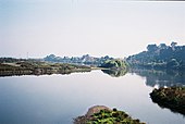
The Río Maipo is one of the longest and most important rivers in Chile with around 250 km. The headwaters are located on the border with Argentina, in the very southeast of the capital region in the municipality of San José de Maipo . There in the Andes in the Los Nacimientos sector at the foot of the Maipo volcano, the water runoff from the western and southern slopes of the volcanic cone and from the south-facing mountains of the caldera boundary collect at an altitude of 3,135 m and form the Río Maipo through their confluence. From Los Nacimientos the Río Maipo initially flows with an average gradient of 2.9% to the northwest to the mouth of the Río Volcán, 62 km away, near the town of San Gabriel. After another 2 km the Río Yeso and after another 25 km the Río Colorado flows into the Maipo. There the river changes direction to the west.

|
The river, which is constantly growing due to its numerous tributaries, overcomes a considerable gradient that is used by hydropower plants to generate electricity or for rafting . The Maipo Gorge, called Cajón del Maipo , and some of its side valleys were already settled in prehistoric times, as numerous archaeological finds show. Today it is the municipality of San José de Maipo , whose widely scattered districts line up there on its banks. The Cajón del Maipo has been a popular tourist attraction and vacation area since the 19th century .
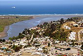
After a total of 110 km, the Río Maipo leaves the Andes Cordillera and enters the Maipo plain at Puente Alto , which is almost 800 m above sea level there. The Río Mapocho , which comes from Santiago, flows into the vicinity of Talagante . After crossing the coastal cordillera , the Río Maipo reaches the village of Llolleo near the port city of San Antonio , where it flows into the Pacific Ocean .

The source region Los Nacimientos , 3135 m above sea level , 34 ° 14 ' S , 69 ° 51' W . Three streams, which in turn form from numerous rivulets, unite here to form the Río Maipo.

The Río Maipo flows over 110 km in the deep gorges through the Andes and has developed into a raging river that for hydropower plants or rafting is used. The Cajón del Maipo (Spanish for Maipo Gorge) is an important holiday region for domestic and foreign tourists.
The Maipo River meanders past numerous cities through the Maipo Plain and the coastal cordillera to the Pacific coast . The sand and gravel washed up from the mountains are mined in the river bed . The agricultural irrigation of the region through which it flows takes place for the most part from its river water.
The Río Maipo often carries so much water that it still reaches the estuary in Llolleo despite considerable withdrawals for intensive irrigation and drinking water production.


Remarks
- ↑ The mountains are called Picos Bayos (Bayos peaks). 34 ° 15 ′ S , 69 ° 50 ′ W
Individual evidence
- ↑ a b c d e f Hans Niemeyer F .: Hoya del Río Maipo . In: Dirección General de Aguas (ed.): Hoyas hidrográficas de Chile. Metropolitan Region . tape 6 . Santiago de Chile ( documentos.dga.cl [PDF; accessed May 7, 2014]).
- ↑ a b cade-idepe consultores en ingenería: Diagnostico de clasificación de los cursos y cuerpos de agua según objeticos de calidad. Cuenca del Río Maipo . Ed .: Dirección General de Aguas, Ministerio de Obras Públicas, Gobierno de Chile. 2004 ( sinia.cl [PDF; accessed on March 18, 2014]). sinia.cl ( Memento of the original dated February 12, 2012 in the Internet Archive ) Info: The archive link was inserted automatically and has not yet been checked. Please check the original and archive link according to the instructions and then remove this notice.
- ↑ Centro de Información de Recursos Naturales: Catastro de usuario / as de aguas superficiales de la primera sección del río Maipo rivera sur o izquierda. Informe Final . Ed .: Dirección General de Aguas, Ministerio de Obras Públicas, Gobierno de Chile. Santiago 2011 ( online [PDF; accessed March 18, 2014]). Catastro de usuario / as de aguas superficiales de la primera sección del río Maipo rivera sur o izquierda. Informe Final ( Memento of the original from March 18, 2014 in the Internet Archive ) Info: The archive link was inserted automatically and has not yet been checked. Please check the original and archive link according to the instructions and then remove this notice.
- ↑ a b Coordinates from GoogleEarth 2014.
- ↑ a b c Mélica Muñoz-Schick, Andrés Moreira-Muñoz, Carolina Villagrán, Federico Lueberti: Caracterización florística y pisos de vegetación en los Andes de Santiago, Chile Central. In: Boletin del Museo Nacional de Historia Natural, Chile . tape 49 , 2000, pp. 9–50 ( ftp.geo.puc.cl [PDF; accessed March 18, 2014]). ftp.geo.puc.cl ( Memento of the original from March 18, 2014 in the Internet Archive ) Info: The archive link was inserted automatically and has not yet been checked. Please check the original and archive link according to the instructions and then remove this notice.
- ↑ Description partly based on the satellite images published in GoogleEarth 2014.