San Pablo (Isabela)
| Municipality of San Pablo | ||
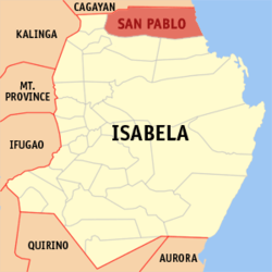
| Location of San Pablo in the province of Isabela | ||
|---|---|---|

|
||
| Basic data | ||
| Region : | Cagayan Valley | |
| Province : | Isabela | |
| Barangays : | 17th | |
| District: | 1. District of Isabela | |
| PSGC : | 023133000 | |
| Income class : | 3rd income bracket | |
| Households : | 3466 May 1, 2000 census
|
|
| Population : | 25,384 August 1, 2015 census
|
|
| Coordinates : | 17 ° 28 ′ N , 121 ° 59 ′ E | |
| Postal code : | 3329 | |
| Mayor : | Antonio N. Miro Jr. | |
| Website: | www.sanpablo-isabela.gov.ph | |
| Geographical location in the Philippines | ||
|
|
||
San Pablo is a township in Isabela Province in the Cagayan Valley District of the Philippines . On August 1, 2015, it had 25,384 residents.
San Pablo is politically divided into 17 barangays :
|
|
