San Ramon (Beni)
| San Ramón | ||
|---|---|---|
| Basic data | ||
| Residents (state) | 3483 pop. (2012 census) | |
| rank | Rank 123 | |
| height | 139 m | |
| Post Code | 08-0702-0100-8008 | |
| Telephone code | (+591) | |
| Coordinates | 13 ° 16 ′ S , 64 ° 37 ′ W | |
|
|
||
| politics | ||
| Department | Beni | |
| province | Province of Mamoré | |
| climate | ||
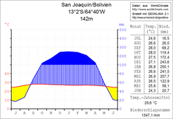
 Climate diagram San Joaquín |
||
San Ramón is a country town in the Beni department in the South American Andean state of Bolivia .
location
San Ramón is the central place of the district ( Bolivian : Municipio ) San Ramón and is located in the canton of San Ramón in the province of Mamoré . The city is located at an altitude of 139 m on the right bank of the Río Machupo , which drains to the Río Iténez . To the east of the city lies the Laguna Grande lake with a length of 2,600 meters and a width of 1,600 meters.
geography
San Ramón is located in the Moxos plain , with over 100,000 km² one of the largest wetlands on earth. The predominant form of vegetation in the San Joaquín region is that of the tropical savannah .
The temperature fluctuations are low, both during the day and during the year (see climate diagram San Joaquín). The annual average temperature is over 26 ° C, the monthly average temperatures are between 24 and 29 ° C. The annual precipitation is around 1500 mm; the months of June to August are characterized by a dry season in which the little rainfall evaporates quickly.
Transport network
San Ramón is located 211 kilometers north of Trinidad , the capital of the Beni department, by road.
The 1,631 kilometer long highway Ruta 9 runs through San Joaquín and crosses the entire Bolivian lowlands and connects Guayaramerin in the north on the Brazilian border with Yacuiba in the south on the Argentine border. It runs as an unpaved road from Guayaramerin between the border river Río Iténez and the Río Yata to the south, crosses the Río Mamoré at Puerto Siles and reaches San Ramón via San Joaquín after a further 88 kilometers . From there it continues via San Pedro Nuevo and San Javier to the departmental capital of Trinidad.
On the eastern edge of the city of San Ramón is the Aeropuerto San Ramón with a 1930 m long unpaved airstrip, which is named SLRA in the ICAO code .
population
The population of the village has remained about the same in the past two decades, but had increased by about a third at the turn of the century:
| year | Residents | source |
|---|---|---|
| 1992 | 3 427 | census |
| 2001 | 4,431 | census |
| 2012 | 3 483 | census |
Individual evidence
- ^ INE - Instituto Nacional de Estadística Bolivia 1992
- ^ INE - Instituto Nacional de Estadística Bolivia 2001
- ↑ INE - Instituto Nacional de Estadística Bolivia 2012 ( Memento of the original from July 22, 2011 in the Internet Archive ) Info: The archive link has been inserted automatically and has not yet been checked. Please check the original and archive link according to the instructions and then remove this notice.
Web links
- Topographic map of the San Joaquín region 1: 100,000 (PDF; 6.2 MB)
- Relief map of the Santa Ana region 1: 250,000 (PDF; 8.3 MB)
- Municipio San Ramón - General Maps No. 80702
- Municipio San Ramón - detailed map and population data (PDF; 1.46 MB) (Spanish)
- Departamento Beni - social data of the municipalities ( Spanish ) (PDF; 3.82 MB)
