Santa Catalina La Tinta
| Santa Catalina La Tinta | ||
|---|---|---|
|
Coordinates: 15 ° 18 ′ N , 89 ° 55 ′ W Santa Catalina La Tinta on the map of Guatemala
|
||
| Basic data | ||
| Country | Guatemala | |
| Department | Alta Verapaz | |
| City foundation | August 14, 1896 | |
| Residents | 27,027 (2002) | |
| - in the metropolitan area | 3,000 | |
| Detailed data | ||
| surface | 196 km 2 | |
| Population density | 138 people / km 2 | |
| height | 195 m | |
| Waters | Río Polochic | |
| Post Code | 16016 | |
| Time zone | UTC −6 | |
| City patron | Santa Catalina de Alejandría (Festival: November 20th to 28th) | |
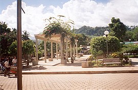
| Central Park | ||
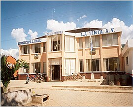
| town hall | ||
Santa Catalina La Tinta (also just called La Tinta ) is a place in Guatemala and the administrative seat of the municipality of the same name in the Alta Verapaz department . Around 30,000 people live in the 196 km² municipality and around 3,000 in La Tinta.
geography
The place Santa Catalina La Tinta is located in the south of Alta Verapaz at an altitude of about 200 m. The municipality extends between the Sierra de Chamá in the north and the Sierra de las Minas in the south in the valley of the Río Polochic . The climate in the valley is influenced by the tropical lowlands of Izabal , in the mountain areas it is more moderate.
The municipality borders on the municipality of Tucurú to the west, Senahú to the north, Panzós to the east, and the Zacapa , El Progreso and Baja Verapaz departments to the south and southwest .
history
The village was called Tuxilá in the Pocomam language . Catholic monks from the Diocese of Verapaz had a convent in Tuxilá . In 1863, the immigration of Germans to Alta Verapaz began with the dealer Heinrich Rudolf Dieseldorff . President Justo Rufino Barrios Auyón (1873–1885) promoted the settlement of people of German origin , granted them privileges, had Ejidoland expropriated and the previous tenants became servants. The indigenous people of Tuxilá lived in Barrio La Línea , Barrio Campo Nuevo and Aldea Sacsuhá . Dieseldorff had acquired the Finca Chipoc near Cobán and operated a factory in Tuxilá in which indigo paint was produced from Indigofera . On August 14, 1896, he had Finca Rústica # 12 entered in the land register of Alta Verapaz and referred to it as Aldea La Tinta . The name referred to the blue, ink-like dye that was commonly called La Tinta . A nearby settlement was mentioned as early as 1770 under the name Santa Catalina .
In 1890 almost all coffee production in the area was in German hands. The workers of the fincas were paid with money that their German employers emitted themselves and that was only valid for the trading companies of the respective fincas themselves or other selected shops. In this way Alta Verapaz became an almost independent economic area in Guatemala. Due to the needs of the export-oriented economy, the infrastructure of the region was improved with German capital and specialist knowledge: among other things, the railway company Ferrocarril Verapaz y Agencia del Norte Limitada was created . In the Polochic Valley between Tucurú and the inland port near Panzós, it operated a very important railway line for coffee export. Coffee and indigo barrels were transported from Tuxilá train station via Panzos, Lake Izabal and the Río Dulce to the Caribbean port of Livingston and then on to Germany.
Jorge Ubico Castañeda was appointed military representative in 1897 and governor of Alta Verapaz in 1906, where he met Erwin Paul Dieseldorff , a nephew of Rudolf Dieseldorff. He ensured the enforcement of existing laws such as the obligation to keep work books and added the Ley contra la vagancia , which Erwin Paul Dieseldorff, Cafetalero of Finca Santa Margarita , had translated from the legislation of the German Empire for German South West Africa .
After the establishment of La Tinta, the place became an Aldea des Municipios Panzós. It is thanks to the long-term efforts of the citizens of La Tinta that the Guatemalan government spun off Aldea from Panzós on November 11, 1999 and elevated it to a municipality. On this occasion, the name Santa Catalina La Tinta was officially established.
population
The Pocomam area was originally inhabited. With the founding of the indigo factory by the Dieseldorffs, the increased need for workers was initially met from neighboring Tucurú, where mainly Pocomchí live. Then came other immigrants from San Pedro Carchá , almost all of whom were kekchí . People of German and Spanish origin mixed with them, creating the Ladino ethnic group. Because of the heterogeneous population composition, Kekchí and Pocomchí are spoken in addition to Spanish.
Economy and Transport
The traffic route through the Polochic Valley to Lake Izabal and further to the Caribbean was once one of the most important trade routes in Guatemala. Therefore, La Tinta was very cheap for a long time. This changed, however, with the construction of the CA 9 Atlantic Highway, which runs from Guatemala City a little further south through the Río Motagua valley to Puerto Barrios . Santa Catalina La Tinta is now off the main traffic routes. At El Rancho, the well-developed CA 14 branches off the Atlantic trunk road CA 9 to the north in the direction of Alta Verapaz. In its southernmost Municipio Tactic , near San Julian, the winding and partly unpaved national road 7 leads east through the Polochic Valley to Izabal . This way, it is around 245 km to Guatemala City and just under 100 km to Cobán, the capital of Alta Verpaz. At the regional level, La Tinta continues to be an important trading center in the Polochic Valley. There is a large market every Tuesday and Thursday. The most important industry is agriculture, especially the cultivation of coffee, cardamom , corn and beans .
Individual evidence
- ↑ Susan Wilkins, Los pocomames en el siglo XVI
- ^ Regina Wagner, William H Hempstead, Cristóbal von Rothkirch, Historia del Café de Guatemala , Asociación Nacional del Café, Villegas Asociados, 2003, 224 pp.
- ^ Regina Wagner, William H Hempstead, Cristóbal von Rothkirch, The history of coffee in Guatemala 223 p., P. 120.
Web links
- History of the municipality (span.)
- Tourist information (span.)


