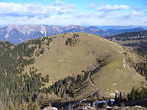
Schönwipfel (1913 m)
| Schönwipfel / Cima Bella | ||
|---|---|---|
| height |
1913 m above sea level A. 1912 m slm |
|
| location | near Vorderberg , Carinthia , and Ugovizza , Friuli-Venezia Giulia | |
| Mountains | Carnic main ridge | |
| Dominance | 0.74 km → Monte Cocco | |
| Notch height | 100 m | |
| Coordinates | 46 ° 33 '24 " N , 13 ° 26' 41" E | |
|
|
||
| rock | lime | |
The Schönwipfel , Italian Cima Bella , is 1913 m above sea level. A. or 1912 m slm high summit of the eastern Carnic main ridge near Vorderberg and Ugovizza .
Location and landscape
The beautifully formed triangular pyramid is located between Gailtal and Kanaltal on the Austrian-Italian border , about 16 kilometers west of the end of the mountain range near Thörl-Maglern . From the Gailtal it is hidden behind the west ridge of the Starhand ( 1965 m above sea level ).
The Grasberg rises just above the tree line . The main ridge runs westwards over the Kesselwaldsattel (Sella della Caldera, 1477 m above sea level ) and to the Schwarzwipfel (approx. 1740 m above sea level ) and northwards to the Poludnig ( 1999 m above sea level ), and eastwards across the Zollhütte (notch at Kalten Brunnen, Forcola di Fontana fredda, 1692 m above sea level ) to Sagran ( 1931 m above sea level ). To the north below is the Uggowitzer Alm (approx. 1730 m above sea level ) and the Kesselwald . To the south stands the Monte Cocco (Kok, 1941 m slm ), the ridge runs over the Stabet ( 1627 m above sea level ) into the Canal Valley.
Politically, the summit belongs to the Carinthian municipality of Sankt Stefan im Gailtal , and to Malborghetto Valbruna in Friuli . In order not to confuse them, the somewhat lower Schönwipfel / Monte Acomizza near Feistritz, 6 kilometers further east, is also known locally as Achomitzer Berg .
The Vorderberger Wildbach flows below the rather steep northern flank , first eastwards and then around Starhand and the Görtschacher Alm to the Gail , a tributary of the Drau to the Danube . In the southeast the Torrente Tamer goes to the Torrente Uqua (Uggwa), which flows into the Fella near Ugovizza . To the southwest the Rio Auernig goes into the Valle di Malborghetto and there to the Fella, which drains over the Tagliamento to the Adriatic Sea. The summit thus belongs to the Mediterranean – Black Sea watershed .
Ascent
The mountain can be easily climbed from all sides and valley locations. The Südalpenweg (03) goes below through the Kesselwald and over the Görtschacher Alm.
The summit is also an easy winter tour.
Individual evidence
- ^ ÖK / AMAP
- ^ Uggowitzer Alm - Monte Cocco. Bergfex.at, accessed October 3, 2015.
- ↑ Schönwipfel (1913 m) / ski tour. alpintouren.com, accessed October 3, 2015.

