Seckach (Lauchert)
| Seckach | ||
|
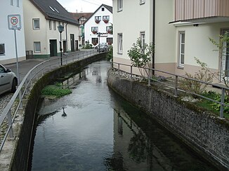
The Seckach in Trochtelfingen about 1 km after its origin |
||
| Data | ||
| Water code | EN : 1122 | |
| location |
Swabian Alb
|
|
| River system | Danube | |
| Drain over | Lauchert → Danube → Black Sea | |
| source | north of Trochtelfingen 48 ° 18 ′ 59 ″ N , 9 ° 14 ′ 57 ″ E |
|
| Source height | little over 700 m above sea level NN | |
| Spring discharge |
MQ |
246 l / s |
| muzzle | south of Mägerkingen from the left in the Lauchert coordinates: 48 ° 17 '2 " N , 9 ° 12' 58" E 48 ° 17 '2 " N , 9 ° 12' 58" E |
|
| Mouth height | 673.5 m above sea level NN | |
| Height difference | 26.5 m | |
| Bottom slope | 4 ‰ | |
| length | 6.6 km | |
| Catchment area | 51.522 km² | |
| Small towns | EZG only : Burladingen | |
| Communities | EZG only: Engstingen , Sonnenbühl , Hohenstein | |
The Seckach is a 6.6 km long river in the Swabian Alb in the area of the small town of Trochtelfingen in the Reutlingen district in Baden-Württemberg , which flows from the left into the upper Lauchert after a southwest run near the Mägerkingen district .
geography
Seckach sources
The Seckach springs are north of Trochtelfingen between the B 313 and the route of the Hohenzollerische Landesbahn in a spring swamp overgrown with reed beds at a little below 700 m above sea level. NN . This is designated as a Natura 2000 protection zone (Habitats Directive). The spring water from numerous karst springs collects in the river bed over a distance of around 200 m . Its catchment area covers 28 km². All of these springs together pour 246 l / s, and they pour pretty consistently over the season. The Seckach is a stately river from its origin.
course
The Seckach flows between its half-timbered houses through the historic town center of Trochtelfingen. After the Mägerkingen district , it flows into its course, about 70 m south of the Lauchtertsee , at 637.5 m above sea level. NN in the Lauchert . In the valley, the aforementioned federal road runs like the railway line to the mouth. Above the springs, the dry Obertal with the name Hasental can be traced northwards for over 4 km to close to the border of the Engstingen community .
Catchment area
The total of 51.5 sq km catchment area of Seckach is located on the plateau of the Swabian Alb in the lower natural area Mean Kuppenalb . The highest point is on the northern tip near the summit of the Hochfleck at 865 m above sea level. NN . At its maximum extent it extends from north to south about 11.5 km and is at most 6 km wide across it. The Seckach has no major tributaries and only flows through the southern half of the catchment area - above the Hasental dry valley continues northwards to almost the Engstingen-Haid business park, the Hohenzollerische Landesbahn runs in the hollow of the entire valley . To the left of this valley axis the forest predominates, to the right of it the open corridor, in which the fields clearly dominate. A few dry valleys run towards the main valley, the longest of which is the Grafental , which comes from the north and flows into the village of Mägerkingen.
By far the largest area of the catchment area belongs to the small town of Trochtelfingen , on the edge other municipalities also have shares - the municipalities of Engstingen in the far north, Sonnenbühl in the northwest and Hohenstein in the northeast and the small town of Burladingen in the west.
Flora and fauna
In the lowlands of Seckachauen one finds the brook thistle , some potamogetonaceae , the butt-edged Water Star , the marsh marigold or Bistort . Furthermore, grasslands and juniper heaths can be found in the Seckach Valley . The upper dry valley is almost free of wood. There are natterjack toad , the sand lizard , the slow worm and the edge ring Fritillary resident. Red-backed shrimp , willow tit , green woodpecker and quail can be seen on some sections of the Seckach.
Protected areas
With the significantly larger part in the dry upper catchment area, the Trochtelfinger Heide and Seckachtal landscape protection area is located . The lowest valley from a little before Mägerkingen, on the other hand, belongs to the Laucherttal landscape protection area with side valleys . The Bauenofen-Häulesrain Valley nature reserve is located near Meidelstetten a little north of the Dachenstein .
Individual evidence
LUBW
Official online waterway map with a suitable section and the layers used here: Course and lower catchment area of the Lauchert
General introduction without default settings and layers: State Institute for the Environment Baden-Württemberg (LUBW) ( notes )
- ↑ a b Height according to the contour line image on the topographic map background layer .
- ↑ Height according to the blue lettering on the background layer topographic map .
- ↑ Length according to the waterway network layer ( AWGN ) .
- ↑ Catchment area according to the basic catchment area layer (AWGN) .
Other evidence
- ↑ a b Filling measured at the Trochtelfingen gauge in the years 1980–1988.
- ↑ Friedrich Huttenlocher : Geographical Land Survey: The natural space units on sheet 178 Sigmaringen. Federal Institute for Regional Studies, Bad Godesberg 1959. → Online map (PDF; 4.3 MB)
literature
- Topographic map 1: 25,000 Baden-Württemberg, as single sheet No. 7621 Trochtelfingen and No. 7721 Gammertingen

