Sedlo (Bohemian Forest Foreland)
| Sedlo | ||
|---|---|---|
|
View from Kašperk Castle over Nový Dvůr to Sedlo |
||
| height | 902 m nm | |
| location | Pilsen , Czech Republic | |
| Mountains | Bohemian Forest Foreland | |
| Coordinates | 49 ° 11 '25 " N , 13 ° 34' 11" E | |
|
|
||
| rock | Gneiss | |
| particularities | Remains of an early castle site, lookout tower | |
The Sedlo (German Rittersattel , also Steinberg , 902 m ) is a wooded mountain in the Czech Republic . It is located five and a half kilometers north of Kašperské Hory or six kilometers southeast of Sušice in the Svatoborská vrchovina ( Swatobor Uplands ) belonging to the Bohemian Forest foothills . At Sedlo there is an early castle stables, which, along with Obří hrad, is one of the highest in Bohemia.
geography
The Sedlo is located in the Kašperská vrchovina Nature Park. The Podmokelský potok ( Albrechtsbach ) rises at its northern foot and the Divišovský potok at the western foot; to the east lies the valley of the Simanovský potok. While the northern flank of the mountain on Albrechtice slopes too gently, the southern slope is steep and rocky.
Surrounding places are Albrechtice in the north, Kadešice, Rozsedly, V Chalupách, Napajedla and Hájovna in the northeast, Strádal, Kakánov and Šimanov in the east, Nezdice na Šumavě , Ostružno and Klepačka in the southeast, U Durmíbeků, České Domky and Nov Žlýbekr in the south , Humpolec and Bohdašice in the southwest, Dlouhá Ves and Platoř in the west and Milčice, Vrabcov and Záluží in the northwest.
history
According to archaeological research, during the younger Hallstatt period (period Ha D2 – D3) and the older La Tène period (period LTA1-LTB1) between 470 and 385 BC A Celtic refugee castle on the Sedlo. In the Latène period LTC2 (180–125 BC) there was again evidence of the use of the castle on the Sedlo. The castle was used for the last time in the 9th and 10th centuries.
At the transition from the 19th to the 20th century, several hiking trails were laid out at Sedlo, the most important of which led from Albrechtsried to Karlsberg Castle . However, the densely forested mountain offered hardly any view and was of little touristic importance. During the Second World War, a military lookout point was built on the Sedlo, which was used until the 1950s. After the army released the Sedlo in the mid-1960s, the former watchtower was increasingly visited by tourists. Over time, the dilapidated buildings and the watchtower finally collapsed. After the Velvet Revolution , the construction of a lookout tower on the Sedlo was considered with the support of sponsors. The construction was completed in the second half of 2009.
Burgstall
The castle complex was protected by a 920 m long wall, which enclosed an area 400 m long and 32 to 114 m wide. The rocks on Sedlo were also drawn into the ramparts. The up to 13 m wide stone walls rose from the inside of the castle by one to one and a half meters; due to the slope of the slope, they reached a height of up to ten meters on the outside. On the dry stone walls of the rampart there was probably a wooden castle accessible from the south-east, the core of which is believed to be in the south-eastern part at the highest point of the protected terrain. Access was via a 17 m long and one and a half meter wide gate. There were no trenches.
Observation tower
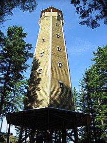
The 27.75 m high tower with a heptagonal floor plan was completed on November 30, 2009 and inaugurated on December 13, 2009. The covered viewing platform is at a height of 23.75 m. To preserve the natural shape of the Sedlo, the summit forest was left in the vicinity of the tower. From the tower, especially to the south, there is a broad view of the Zámecký vrch ( Castle Hill ) with the Kašperk Castle and the ridge of the Bohemian Forest with the Great Arber ( Velký Javor ), Great Rachel ( Velký Roklan ), Pancíř ( Panzer ), Špičák ( Spitzberg ), Poledník ( Mittagsberg ), Ždánidla ( Steindlberg ), Huťská hora ( Knappenberg ), Ždánov ( Zosumberg ) and Javorník ( Jawornik ). The view in other directions is restricted by tall trees, the Čerchov ( Schwarzkopf ), the Svatobor ( Swatobor ), the Rabí Castle and the St. Maurenzen Church are visible .


