
Kulkwitz
|
Kulkwitz
City of Markranstädt
Coordinates: 51 ° 16 ′ 46 ″ N , 12 ° 13 ′ 51 ″ E
|
||
|---|---|---|
| Height : | 130 m | |
| Incorporation : | January 1, 1999 | |
| Postal code : | 04420 | |
| Area code : | 034205 | |
Location of Kulkwitz in Saxony |
||

Kulkwitz is a village in the town of Markranstädt in the Leipzig district in Saxony . The districts Kulkwitz, Gärnitz and Seebenisch belong to the village.
geography
Kulkwitz is located in the Leipzig lowland bay south of Markranstädt and southwest of Leipzig . To the northeast of Kulkwitz lies the Kulkwitzer See , which was created by flooding two remaining open-cast mine holes.
history

The Kulkwitz Church in 1840
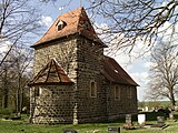
... and 2012


Kulkwitz was first mentioned in 1358 as Kolkwiz. The fortified church of Kulkwitz dates from the 12th century. It was built in the Romanesque style. In 2015, Romanesque wall paintings from the 13th century were discovered in it, "which belong to the highest quality and oldest inventory in today's Free State of Saxony".
Kulkwitz and its current districts of Gärnitz and Seebenisch belonged to the Hochstift-Merseburg office of Lützen until 1815 , which had been under Electoral Saxon sovereignty since 1561 and belonged to the Secondogenitur Principality of Saxony-Merseburg between 1656/57 and 1738 . Through the resolutions of the Congress of Vienna , the western part of the Lützen district was ceded to Prussia in 1815. Kulkwitz, Gärnitz and Seebenisch, however, remained with the eastern part of the office in the Kingdom of Saxony . They were affiliated to the Leipzig district office. From 1856 the places belonged to the Markranstädt court office and from 1875 to the Leipzig district administration .
After lignite was found in the 19th century, lignite mining began between Göhrenz and Kulkwitz, initially underground (Albert-Schacht, Carola-Schacht). In 1936 the underground mining was switched to open-cast mining and expanded in the direction of Lausen , which greatly changed the landscape in this area. After the last opencast mine on Kulkwitzer Flur had been charred, the flooding of the remaining holes began in 1962, from which the Kulkwitzer See arose.
On April 1, 1936 Gärnitz was incorporated into Kulkwitz, Seebenisch followed on July 1, 1948. During the district reform in the GDR , Kulkwitz and its two districts came to the newly formed Leipzig-Land district in the Leipzig district in 1952 .
During the district reform of the Free State of Saxony, the municipality of Kulkwitz was assigned to the district of Leipziger Land in 1994 . On March 1, 1994, Knautnaundorf was incorporated with its district Rehbach and the corridors of Bösdorf and Eythra that had been devastated by the Zwenkau opencast mine . On January 1, 1999, the Kulkwitz community was dissolved. Kulkwitz came to Markranstädt with Gärnitz and Seebenisch, while Knautnaundorf was incorporated into Leipzig with Rehbach and the corridors of Bösdorf and Eythra.
traffic
The federal highway 186 runs through Kulkwitz . The A38 is south of Seebenisch .
Web links
- Kulkwitz in the Historical Directory of Saxony
- History of the districts of Markranstädt on the city's website
Individual evidence
- ^ Romanesque paintings discovered in Kulkwitz Church , Leipziger Volkszeitung, December 4, 2015, p. 25
- ^ Karlheinz Blaschke , Uwe Ulrich Jäschke : Kursächsischer Ämteratlas , Leipzig 2009, ISBN 978-3-937386-14-0 , p. 84 f.
- ↑ The Amtshauptmannschaft Leipzig in the municipal register 1900
- ↑ Kulkwitz on gov.genealogy.net

Districts: Albersdorf | Altranstädt | Döhlen | Frankenheim | Gärnitz | Goehrenz | Großlehna | Kulkwitz | Lindennaundorf | Meyhen | Priestly | Quesitz | Räpitz | Schkeitbar | Schkölen | Seebenisch | Thronitz