Stöckheim (Rohrberg)
|
Stockheim
Municipality Rohrberg
Coordinates: 52 ° 42 ′ 33 ″ N , 10 ° 59 ′ 43 ″ E
|
|
|---|---|
| Height : | 52 m |
| Area : | 5.55 km² |
| Residents : | 151 (December 31, 2018) |
| Population density : | 27 inhabitants / km² |
| Incorporation : | April 1, 1974 |
| Incorporated into: | Ahlum |
| Postal code : | 38489 |
| Area code : | 039007 |
Location of Stöckheim in Saxony-Anhalt |
Stöckheim is a district of the Rohrberg municipality in the Altmarkkreis Salzwedel in Saxony-Anhalt .
geography
The Altmark village of Stöckheim, a street village with a church, is located three kilometers west of the Rohrberg community and 19 kilometers southwest of the district town of Salzwedel . To the east of the street village are the Hörsten forest area and the Königsberg mountains.
history
In 1254, Philippus de Stockem is mentioned as a witness in Gardelegen.
In 1357 Stöckheim was mentioned for the first time as Stockenn (in a copy of the Schulenburger Kopialbuch of the Provoste Salzwedel). Hanns HF Schmidt writes that the village is mentioned in the first documentary mention Vlemeschen Stockem . He is probably referring to Johann Friedrich Danneil , who gives a document in the files of the Katharinenkirche in Salzwedel as the source.
In 1945, 160 hectares were expropriated as part of the land reform and divided among 32 settlers. In 1948 there were reports of 31 buyers from the land reform, 15 of them new settlers.
In 1952 the first type III agricultural production cooperative was established, the LPG "Rotes Banner", which was connected to type III LPG in Ahlum after 1959. In 1959 the second LPG "United Force" of type III was set up.
Incorporations
The community of Stöckheim was reclassified from the district of Salzwedel to the new district of Klötze on July 25, 1952 . On April 1, 1974, the community of Stöckheim was incorporated into the community of Ahlum in the same district.
Population development
|
|
|
|
Swell:
religion
The Protestant parish of Stöckheim used to belong to the parish of Ahlum. In 2003, the parishes Rohrberg, large and small Bierstedt, Mellin, Stöckheim, Tangeln and Püggen were pooled Parish Rohrberg, which is now the parish area Rohrberg the church district Salzwedel in Propst Sprengel Stendal Magdeburg of the Evangelical Church in Central Germany belongs.
Culture and sights
- The Protestant village church of Stöckheim is a rectangular, in the core Romanesque field stone hall with a west transverse tower. The walled-up Romanesque openings with brick surrounds are still partially visible. It is a branch church of the church in Ahlum.
- The cemetery is next to the church.
- At the entrance to the cemetery there is a boulder in memory of those who fell in the First World War.
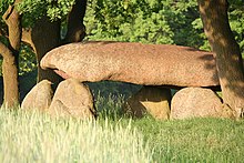
- South of the village is the Stöckheim large stone grave, a Neolithic megalithic grave complex around which a Goliath legend is entwined.
societies
- Hunting company Stöckheim, based in Lüdelsen
literature
- Peter P. Rohrlach: Historical local lexicon for the Altmark (Historical local lexicon for Brandenburg, Part XII) . Berliner Wissenschafts-Verlag, Berlin 2018, ISBN 978-3-8305-2235-5 , pp. 2169-2172 .
- Wilhelm Zahn : Local history of the Altmark . Edited by Martin Ehlies based on the bequests of the author. 2nd Edition. Verlag Salzwedeler Wochenblatt, Graphische Anstalt, GmbH, Salzwedel 1928, DNB 578458357 , p. 154 .
- JAF Hermes, MJ Weigelt: Historical-geographical-statistical-topographical handbook from the administrative districts of Magdeburg . Topographical part. Ed .: Verlag Heinrichshofen. tape 2 , 1842, p. 347 , 158. Stöckheim ( digitized version ).
Web links
- Stöckheim in the historical directory of the association for computer genealogy
Individual evidence
- ↑ a b c d e f g Peter P. Rohrlach: Historical local lexicon for the Altmark (Historical local lexicon for Brandenburg, Part XII) . Berliner Wissenschafts-Verlag, Berlin 2018, ISBN 978-3-8305-2235-5 , pp. 2169-2172 .
- ↑ a b Verbandsgemeinde Beetzendorf-Diesdorf: residents of the districts on December 31 for 2015 and 2018 . June 6, 2019.
- ↑ Saxony-Anhalt viewer of the State Office for Surveying and Geoinformation ( notes )
- ^ Hermann Krabbo: Regesta of the Margraves of Brandenburg from Ascanic house . Ed .: Association for the history of the Mark Brandenburg. 1. Delivery. Duncker & Humblot, Leipzig 1910, p. 179 , No. 774 ( uni-potsdam.de ).
- ^ Adolph Friedrich Riedel : Codex diplomaticus Brandenburgensis : Collection of documents, chronicles and other source documents . Main part 1st volume 5 . Berlin 1845, p. 333 ( digitized version ).
- ^ Hanns HF Schmidt , Gerald Grosse: Sketches from the Altmark . Greifenverlag, Rudolstadt 1990, p. 21 .
- ^ Johann Friedrich Danneil : The gender of the Schulenburg . tape 1 . Salzwedel 1847, p. 317 ( digitized version ).
- ↑ Federal Statistical Office (Ed.): Municipalities 1994 and their changes since 01.01.1948 in the new federal states . Metzler-Poeschel, Stuttgart 1995, ISBN 3-8246-0321-7 , pp. 357, 362 .
- ^ Wilhelm Zahn : Heimatkunde der Altmark . Edited by Martin Ehlies based on the bequests of the author. 2nd Edition. Verlag Salzwedeler Wochenblatt, Graphische Anstalt, GmbH, Salzwedel 1928, DNB 578458357 , p. 154 .
- ↑ Parish Almanac or the Protestant clergy and churches of the Province of Saxony in the counties of Wernigerode, Rossla and Stolberg . 19th year, 1903, ZDB -ID 551010-7 , p. 23 ( wiki-de.genealogy.net [accessed April 6, 2018]).
- ↑ Rohrberg parish area. Retrieved April 6, 2018 .
- ^ Association for pastors in the Evangelical Church of the Church Province of Saxony e. V. (Ed.): Pastor's Book of the Church Province of Saxony (= Series Pastorum . Volume 10 ). Evangelische Verlagsanstalt, Leipzig 2009, ISBN 978-3-374-02142-0 , p. 65 .
- ↑ Online project monuments to the likes. In: Stöckheim at www.denkmalprojekt.org. April 1, 2018, accessed June 14, 2019 .

