Ste. Genevieve (Missouri)
| Ste. Genevieve | |
|---|---|
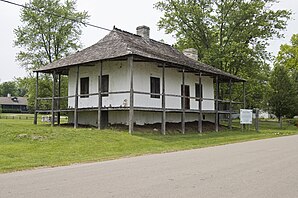
 Maison Bequette-Ribault in Ste. Genevieve |
|
| Location in Missouri | |
| Basic data | |
| Foundation : | around 1750 |
| State : | United States |
| State : | Missouri |
| County : | Ste. Genevieve County |
| Coordinates : | 37 ° 59 ′ N , 90 ° 3 ′ W |
| Time zone : | Central ( UTC − 6 / −5 ) |
| Residents : | 4,476 (as of: 2000) |
| Population density : | 414.4 inhabitants per km 2 |
| Area : | 10.8 km 2 (approx. 4 mi 2 ) of which 10.8 km 2 (approx. 4 mi 2 ) is land |
| Height : | 117 m |
| Postcodes : | 63670 |
| Area code : | +1 573 |
| FIPS : | 29-64180 |
| GNIS ID : | 0727043 |
| Website : | www.ste-genevieve.com |
Ste. Genevieve (French: Ste-Geneviève ) is the administrative seat of the Ste. Genevieve County in the southeast of the US -amerikanischen State of Missouri with 4476 inhabitants. Ste. Genevieve is on the west bank of the Mississippi River .
geography
Ste. Genevieve is located at 37 ° 58'37 "north latitude and 90 ° 02'55" west longitude. The city extends over 10.8 km², which consists exclusively of land. Ste. Genevieve is located on the western bank of the Mississippi River, which forms the border between the states of Missouri and Illinois . US Highway 61 runs through the city . This flows into Ste. Genevieve the Missouri State Route 32 and thus reaches its eastern end point. 10 km west of the city runs of Chicago through St. Louis and Memphis to New Orleans leading Interstate 55 . A ferry connects St. Genevieve with Modoc, Illinois on the opposite bank of the Mississippi. Ste. Genevieve is 108 kilometers south of St. Louis and 364 kilometers north of Memphis.
history
The place was founded around 1750 by French settlers and refugees from the area east of the Mississippi. Ste. Genevieve, named after the patron saint of Paris , is the oldest permanent settlement of European immigrants west of the Mississippi. Most of the residents at the time were of French-Canadian descent, while the founding families had lived in the Mississippi area for several generations. In the time before the Louisiana Purchase , the region was called Illinois Country (French Pays des Illinois ) or Upper Louisiana (French Haute-Louisiane ). Old sources suggest that Ste. Genevieve around the year 1735, but the majority of surviving documents assume a time around 1750. The population east of the Mississippi needed more land, the soils of the old villages were depleted and the decreasing pressure from hostile Indians made settlement possible.
The Mississippi culture , which existed from about AD 700 to about AD 1500, and much earlier cultures were the first civilizations in the region. Nevertheless, no Indians lived near the western Mississippi bank during the time of European settlement. A map by Jacques-Nicolas Bellin from 1755, on the Ste. Genevieve was shown for the first time, showed settlements of the Kaskaskia Indians on the east bank, but not on the west bank over a section of about 160 km.
At the time of its inception, Ste. Genevieve the youngest of a group of three French settlements in the central Mississippi Valley. Fort de Chartres , which was the official capital of the Pay de Illinois at that time, was 8 km northeast on the east bank . Kaskaskia (later the first capital of the state of Illinois) was about 8 km southeast. Cahokia and Prairie du Rocher in Illinois on the east bank were also early French settlements.
After the Peace of Paris (1763) , which was concluded after the French and Indian War (called the Seven Years War in Europe ), France ceded the entire area east of the Mississippi to Great Britain . After the royal proclamation of 1763 , which designated the entire area between the Appalachians and the Mississippi as Indian land, French-speaking Canadians and settlers from the area east of the Mississippi increasingly came to the area west of the Mississippi, including Ste. Genevieve.
In the previously concluded Secret Agreement of Fontainebleau between France and Spain , the entire area west of the Mississippi was ceded to Spain, which called this area New Spain . Spain moved the capital of upper Louisiana from Fort des Chartres to St. Louis, 80 km south . Although Ste. Genevieve now came under Spanish control, the city retained its French character, linguistically and culturally, for the next 40 years.
During the 1770s, Ste. Genevieve was repeatedly ambushed by Osage and Missouri Indians to steal horses from the settlers. But there was also increased contact between the Indians and the French, especially through marriage and trade. In the 1780s, as a result of their suppressed uprising against the newly formed United States, Shawnee and Delawaren crossed the Mississippi and settled south of Ste. Genevieve on. The Peoria also settled in the area around Ste. Genevieve and there was a peaceful coexistence with the settlement until the 1790s. After 1790, however, attacks by Osage increased and fatal clashes increased. The Osage also attacked the Shawnee and Peoria.
The Spanish authorities wanted to pacify the Indian tribes by force, but could not find enough French settlers to set up a militia. Rather, the extensive trade contacts with the Indians made it much easier to find a negotiated solution.
After the flooding in 1785, the city was moved from its original location in the middle of the floodplain around 3 km to the north and rebuilt a little further from the bank. The city developed into a center for the surrounding agriculture, especially the wheat, corn and tobacco cultivation, which was carried out by mostly independent family farms. More and more agricultural products were produced, which, in addition to self-sufficiency, also allowed an increasing supply of flour and grain to the lower Mississippi area and export via the port of New Orleans. In 1807, then Secretary of State for the Louisiana Territory , Frederick Bates , said that Ste. Genevieve is the wealthiest place in Louisiana. For decades, Ste. Genevieve predominantly agricultural. Mainly wheat, corn and tobacco were grown. The products were shipped to St. Louis and beyond to New Orleans. The traditional practice was that most of the residents lived in the city and worked their fields outside the city. These lay together and fenced off on the common outside.
After the Louisiana Purchase in 1803, many Anglo-American and German settlers came to the place. Gradually trade and industry began to gain importance, but culturally the place retained much of its French character. The Institut des sœurs de saint Joseph ( Sisters of St. Joseph ), a French teaching order, founded a convent in the city and ran a school. The city's Catholic church was built in 1876 and is based on French church buildings.
architecture
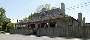
The oldest buildings in Ste. Genevieve, whose architecture is known as the French Creole Colonial style , all date from the time of Spanish rule. The characteristic buildings from this period were built around wooden posts anchored vertically in the ground ( poteaux en terre ) or on a stone foundation ( poteaux sur solle ). This style is fundamentally different from the classic American log houses , which are made of horizontally arranged beams. Three of the five buildings of this type still preserved in the United States are in Ste. Genevieve.
There are also a number of buildings erected around vertical wooden posts that stand on a horizontal beam. The oldest building in the city is the Louis Bolduc House .
Culture
The French heritage of Ste. Genevieve is kept alive by annual festivals such as La Guiannée , French Fest , Jour de Fête , King's Ball and others. The ferry from Ste. Genevieve to Modoc in Illinois is popularly known as the French Connection because it connects various sights from the French colonial era.
Demographic data
In the 2010 census, the population was 4,410. These were distributed over 1,824 households in 1,187 families. The population density was 415.4 / km². There were 1,965 buildings, which corresponds to a building density of 182.4 / km².
The population in 2000 was 96.07% White , 2.14% African American , 0.58% Native American , 0.31% Asian, and 0.25% other. 0.65% said they came from at least two of these groups. 1.12% of the population was Hispanic from any of the above groups.
21.9% were under 18 years of age, 7.7% between 18 and 24, 25.0% between 25 and 44, 21.8% between 45 and 64 and 23.6% 65 and older. The average age was 42 years. For every 100 women there were statistically 92.7 men, 89.8 among the over 18-year-olds.
The median income per household was $ 33,929 and the median family income was $ 43,125. The average income for men was $ 31,546 and that for women was $ 19,804. The per capita income was $ 17,361. Around 7.8% of families and 9.6% of the total population had their income below the poverty line .
Individual evidence
- ↑ US Postal Service - ZIP Codes
- ↑ Carl J. Ekberg, Colonial Ste. Genevieve: An Adventure on the Mississippi Frontier , Gerald, MO: The Patrice Press, 1985, pp. 15-20
- ↑ Carl J. Ekberg, Colonial Ste. Genevieve: An Adventure on the Mississippi Frontier , Gerald, MO: The Patrice Press, 1985, p. 25
- ↑ Carl J. Ekberg, Colonial Ste. Genevieve: An Adventure on the Mississippi Frontier , Gerald, MO: The Patrice Press, 1985, p. 87
- ^ A b Carl J. Ekberg, Colonial Ste. Genevieve: An Adventure on the Mississippi Frontier , Gerald, MO: The Patrice Press, 1985, pp. 87-104
- ^ Carl J. Ekberg: Colonial Ste. Genevieve: An Adventure on the Mississippi Frontier. The Patrice Press, Gerald, MO 1985, p. 177.
- ^ Carl J. Ekberg: Colonial Ste. Genevieve: An Adventure on the Mississippi Frontier. The Patrice Press, Gerald, MO 1985, pp. 130-132.
- ↑ Visitors Guide to Ste. Genevieve
- ↑ Genevieve city, Missouri / POPULATION / DECENNIAL_CNT US Census Bureau - Ste. Genevieve, Missouri

