
Ditch
| Ditch | ||
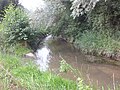
 Stechgraben at the sheep bridge west of Rödersheim-Gronau with field cross at the eastern outlet of the retention and renaturation area from 2013 |
||
| Data | ||
| Water code | DE : 239148826 | |
| location | Rhineland-Palatinate | |
| River system | Rhine | |
| Drain over | Floßbach → Isenach → Rhine → North Sea | |
| source | Source collector east of Forst on Weinstrasse 49 ° 25 ′ 35 ″ N , 8 ° 11 ′ 24 ″ E |
|
| Source height | 112 m above sea level NN | |
| muzzle | In Dannstadt-Schauernheim in the Floßbach coordinates: 49 ° 26 '22 " N , 8 ° 18' 49" O 49 ° 26 '22 " N , 8 ° 18' 49" O |
|
| Mouth height | 96 m above sea level NN | |
| Height difference | 16 m | |
| Bottom slope | approx. 1.7 ‰ | |
| length | approx. 9.5 km | |
| Catchment area | 34.9 km² | |
| Left tributaries | Wachenheimer Bach | |
| Communities | Forest on the Weinstrasse , Rödersheim-Gronau , Dannstadt-Schauernheim | |
The Stechgraben is a third order body of water almost 9.5 km long in the Palatinate . It carries water all year round, an average of 120 l / s, in extreme floods up to 6.5 m³ / s. The average gradient is 12.6 ‰. It drains indirectly into the Rhine via the Floßbach . On the municipal side, the Isenach- Eckbach water authority is responsible for looking after the digging ditch .
course
The ditch itself is about 9 km long. Its main tributaries are the Goldbach and the Burgtalbach, which arise in the Wachenheim district. The Burgtalbach flows north below the Wachtenburg from the valley through Wachenheim an der Weinstrasse into the Upper Rhine Valley. The water from the Wachenheim sewage treatment plant is also fed into the Stechgraben via the Burgtalbach. There are also 17 further drainage ditches in the further course of the ditch.
According to the topographical map from 2014, the Stechgraben begins with the piped outlet of part of the spring horizon in the Wassergasse in Forst an der Weinstrasse . The further source horizon in the Forster local area on the western edge of the Haardland of the Palatinate Forest drains via a collector into a rain retention pond east of Forst on the embankment between Wachenheim and Deidesheim .
The Goldbächl, which rises in the district of Wachenheim at the foot of the Wachtenburg castle ruins, also flows into this . The drainage of the pond flows into the further stream bed of the Stechgraben to the east.
After the railway embankment, the Burgtalbach (formerly also known as Wachenheimer Bach) flows from Wachenheim into the Stechgraben bed. This rises on the Rotsteiger Kopf and flows through the Wachenheim valley below the Wachtenburg past the Wachenheim sewage treatment plant, which feeds the treated wastewater there, north to the Stechgraben.
From there, the Stechgraben flows through the Deidesheim, Niederkirchen and Rödersheim-Gronau districts towards Schauernheim. A series of drainage ditches lead the water out of the corridors, which is brought in as rainwater runoff and also comes from the spring horizons, especially east and north of Rödersheim-Gronau. There it joins briefly with the Marlach, whose bed runs parallel south of the Stechgraben from Meckenheim via Hochdorf-Assenheim to Dannstadt-Schauernheim . After the introduction of further drainage ditches, the Stechgraben flows east of Schauernheim into the Floßbach . This flows east of Lambsheim into the Isenach , which ultimately drains into the Rhine via the Roxheimer Altrhein .
Historically, the course has been defined slightly differently. The source was defined as an outlet in the cellar of the former Buhlschen winery on the Weinstrasse in Forst. However, since this source is only one of several outlets in cellars after inspections by employees of the Rödersheim-Gronau Museum, the westernmost piped outlet was probably defined as the beginning of the stream. There is no written greening. In earlier descriptions, the stream ended with the union with the Marlach. However, since this now carries less water than the Stechgraben and is completely piped for the last 100 meters or so, the further course up to the confluence with the Floßbach is now called Stechgraben. The competent authority could not give any other reason than this, but it was not confirmed in the interview.

Stechgraben, source and drainage ditch collectors at the source horizon in Forst an der Weinstrasse

Stechgraben, retention and collection pond in front of the railway embankment near Forst on the Weinstrasse

Stechgraben in Rödersheim-Gronau with a bridge in the "Gässl" at the back of a barn
Stechgraben / Marlach confluence with the Floßbach


Surname
The name Stechgraben is consistently listed on the maps of the Rödersheim-Gronau museum archive . The name probably comes from the fact that the stream bed as an essential drainage element of the adjacent districts has been repeatedly changed and re-cut over the centuries. The changes in the course are clearly visible in these maps.
Local historical significance
According to the settlement tactics in the time of the so-called Franconian land grabbing from the sixth century, the Stechgraben can be seen as settlement ground for the founding groups of Alasheim and Ratherisheim, the two current districts of Rödersheim-Gronau. The area was swampy and moist due to the ditch and the spring horizons on both sides. Settlement troops dug drainage ditches that drained over the ditch and thus made the areas arable.
_Roe_Ausschnitt.jpg)
Old maps, including the renovation map from 1776, show a partly filled village pond. According to the information in the local chronicle from 1978, the pond was initially partially filled in 1738 with rubble from the demolition of the Catholic Church and a ramp was built in the bed of the stream, with which carts and draft animals could be brought into the bed and cleaned. The ramp can be seen in photos from before 1909. The village pond was then completely backfilled and built on during the expansion of the church, the ramp was abandoned and the stream bed in this area was concreted and canalized. However, these measures did not help to cope with the floods.
In the local history, later floods in Rödersheim are reported several times. There are also pictures from around 1940.

At least in 1942, the stream bed was re-tapped to allow faster drainage through straightening. At the same time - according to the report of the co-author of the Ortschronik from 1978, Erwin Hettich - the creek bed was relocated into the remaining inner ring trench of the demolished Niederungsburg Burg Gronau . Until then, the creek bed was north of it, and the ditch supplied the moat with water. The trenches were filled with carp. The connection to the ditch above the trenches was closed for fishing and the fish were collected after the trenches were empty. The barrier was then reopened and the trenches flooded.
Rain retention basins and renaturation measures since 2005
In the last decades of the 20th century, however, not only were the rivers straightened, but also ditches and streams were redesigned almost exclusively for use in hydraulic engineering. They were degraded to receiving waters that had to drain the landscape, quickly remove sewage and refuse, and discharge floods without damage. The natural functions of the waters were lost. Stream straightening, piping and the removal of wood on the banks not only destroyed the landscape, but two thirds of all animal and plant species that live in and around the water are now extinct or endangered.
A special study of the chemistry and biological quality of the rivers in the Isenach catchment area 2001/2002 also showed that 69% of the study sections do not achieve the minimum water management goal of water quality class II. 38% of the bodies of water examined were critically polluted, 31% heavily. Only 13% of the waters achieved quality class II, and only 9% achieved quality classes I and I-II. The source areas of the brooks mostly had good to very good water quality, but this was greatly impaired by feed lines from trade and industry as well as primarily by substance inputs from agriculture due to the lack of buffer zones on the banks in the further course of the brooks - including the Stechgraben and its tributaries.
The last investigation of the water quality in 2007 determined a saprobial index of 2.4 for the Stechgraben . With further indices and measured values, a quality class III, at best II-III, resulted. The rather high pollution already at the collecting pond and shortly afterwards is mainly due to the inputs from the intensive agricultural-industrial use of the surrounding areas. In the opinion of Petra Jörns, this is essentially due to the drainage function of the ditch for the adjacent agricultural areas. With the draining water, the extensive residues of fertilizers and pesticides get into the ditch water. The renaturation should therefore lead to better values in future studies.
In 2003, the Structural and Approval Directorate South had an overall water management concept drawn up for the Isenach and Eckbach catchment area, which aims to improve local flood protection. After the retention basin east of Hochdorf-Assenheim was completed in May 2009, a second retention basin was built at the Stechgraben west of Rödersheim-Gronau by September 2011. Special emphasis was placed on a natural design of the trench so that the passage for Fish is guaranteed. The stream was given a meandering bed that lies in a spacious flood basin. Existing old trees were left wherever possible. The rest of the new stream was alternately planted with trees appropriate to the location in order to create a natural stream backdrop. The flood basin was partly left to natural succession and partly provided with seeds obtained from the Ruchheimer Wiese natural monument and the Haderwiese nature reserve. In the future, it will be kept open as part of the maintenance measures, so that a floodplain with the naturally occurring animal and plant species can develop.
In the town there are still piped areas and base fortifications that reduce the patency of the trenches and streams.
The first typical species of the stream meadows such as broad-leaved cattails, reeds, purple loosestrife and pond horsetail have already settled again. Rarities such as common marshmallow, asparagus bean and creeping hawk have already been spotted. Resettlements have also been found in the fauna, including azure damsel, flat bellies, banded dragonflies, darter and butterflies such as checkerboard butterflies, cabbage white butterflies, great ox-eye and thick-headed butterflies. Sticklebacks, back swimmers, water snails, dragonfly larvae and water striders can be found in the water - the small pond newt is suspected.
List of species of the identified plants, status 2014
| German name | Botanical | German name | Botanical |
|---|---|---|---|
| Couch grass | Agropyron repens | Flutter rush | Juncus effusus |
| Dog ostrich grass | Agrostis canina | Meadow pea | Lathyrus pratensis |
| Red ostrich grass | Agrostis capillaris | Horn clover | Lotus corniculatus |
| Real marshmallow | Althaea officinalis | Purple loosestrife | Lythrum salicaria |
| Stench grass | Anthoxanthum odoratum | Hop clover | Medicago lupulina |
| Winch | Calystegia sepium | Creeping Restharrow | Ononis spinosa |
| Rust sedge | Carex ferruginea | reed | Phragmites communis |
| Small-headed Pippau | Crepis capillaris | Creeping cinquefoil | Potentilla reptans |
| Creeping cinquefoil | Potentilla reptans | Wild carrot | Daucus carota |
| Creeping buttercup | Ranunculus repens | Lawn Schmiele | Deschampsia cespitosa |
| Curled dock | Rumex crispus | Shaggy fireweed | Epilobium hirsutum |
| Yellow asparagus bean | Tetragonolobus maritimus | Field horsetail | Equisetum arvense |
| Hybrid clover | Trifolium hybridum | Pond horsetail | Equisetum fluviatile |
| Red clover | Trifolium pratense | Woolly honeygrass | Holcus lanatus |
| Broad-leaved cattail | Typha latifolia |
literature
- Sebastian Arnold (Ed.): Wendezeiten - News from the history of Rödersheim-Gronau , Part 1, localization. Rödersheim 2009 (introduction).
- Isenach-Eckbach water body association: flood retention at the Stechgraben west of Rödersheim .
- Petra E. Jörns: lifeline, sewerage, biotope: a village stream like the Stechgraben , in the district yearbook of the Rehin-Pfalz-Kreis, vol. 30, Ludwigshafen 2014 (self-published by the district).
- Structure and Approval Directorate South: Overall water management concept for the catchment area of Isenach and Eckbach , Neustadt / Wstr. 2003.
Web links
Individual evidence
- ↑ a b Data taken from GoogleEarth
- ↑ Own measurement at GeoPortal.rlp
- ↑ GeoExplorer of the Rhineland-Palatinate Water Management Authority ( information )
- ↑ Measurements of the stream marked with Stechgraben in www.geoprtal.rlp.de using the measuring tool offered there
- ↑ Measurements of the stream marked with Stechgraben in www.geoprtal.rlp.de using the measuring tool offered there
- ↑ http://www.geoportal.rlp.de/portal/karten.html?WMC=2506 ; by entering "Forst an der Weinstrasse"
- ↑ According to Ortschronik Vol. 2 "Wendezeiten", Chapter 2
- ↑ Petra E. Jörns: lifeline, sewerage, biotope: a village stream like the Stechgraben , in the district yearbook of the Rehin-Pfalz-Kreis, vol. 30, Ludwigshafen 2014.
- ↑ The last measurements showed only medium to moderate water quality for the Stechgraben in spite of the sewage treatment plant (According to "Geoportal Wasser Rheinland-Pfalz": http://213.139.159.46/prj-wwvauskunft/projects/messstellen/biologie/register2.jsp?intern=false&msn = 2391899300 & measuring point designation = Stechgraben,% 20uh.% 20Gronau & measuring point type number = 228 )
- ↑ All of the following information according to Jörns